Whitehorse Mountain (Washington)
| Whitehorse Mountain | |
|---|---|
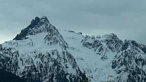
 NW face from the Mount Higgins Trail | |
| Elevation | 6,840+ ft (2085+ m) NGVD 29[1] |
| Prominence | 2,160 ft (660 m)[1] |
| Location | |
| Location | Boulder River Wilderness, Snohomish County, Washington, U.S. |
| Range | North Cascades |
| Coordinates | 48°12′41″N 121°40′41″W / 48.2114961°N 121.6781825°WCoordinates: 48°12′41″N 121°40′41″W / 48.2114961°N 121.6781825°W[2] |
| Topo map | USGS Whitehorse Mountain |
| Climbing | |
| First ascent | 1909 by Nels Bruseth[3] |
| Easiest route | Northwest Shoulder (hike/snow climb/scramble)[3] |
Whitehorse Mountain is a peak near the western edge of the North Cascades in Washington state. It is located just southwest of the Sauk River Valley town of Darrington, near the northern boundary of Boulder River Wilderness in Mount Baker-Snoqualmie National Forest. While not of particularly high absolute elevation, even for the North Cascades, it is notable for its large, steep local relief. For example, its north face rises 6,000 feet (1,830 m) in only 1.8 mi (2.9 km).
Whitehorse Mountain was first climbed in 1909 by Nels Bruseth. The standard route on the peak is via the Northwest Shoulder, which begins with a difficult trail hike, involves a good deal of snow climbing, and culminates with some exposed scrambling, class 3. The net elevation gain is about 6,000 feet (1,828.80 m), making this a strenuous outing. Other routes include the Whitehorse Glacier on the north side of the peak, the East Ridge, and the Southeast Ridge.[3]
References
- ↑ 1.0 1.1 "Whitehorse Mountain, Washington". Peakbagger.com.
- ↑ "Whitehorse Mountain". Geographic Names Information System. United States Geological Survey.
- ↑ 3.0 3.1 3.2 Beckey, Fred W. (2003). Cascade Alpine Guide, Vol. 2, Stevens Pass to Rainy Pass (3rd ed.). Seattle: Mountaineers Books. pp. 129ff. ISBN 0-89886-838-6.
External links
- "Whitehorse Mountain" (map). TopoQuest.
- "Whitehorse Mountain". SummitPost.org.
- "Whitehorse Mountain". Bivouac.com.
- "Jeff Howbert's Master List of Peaks in Washington". The Northwest Peakbaggers Asylum.
| Wikimedia Commons has media related to Whitehorse Mountain. |