Whitehall

Whitehall is a road in the City of Westminster, in central London, which forms the first part of the A3212 road from Trafalgar Square to Chelsea. It is the main thoroughfare running south from the site of the original Charing Cross at the southern end of Trafalgar Square towards Parliament Square. Recognised as the centre of Her Majesty's Government, the street is lined with government departments and ministries; the name "Whitehall" is thus also frequently used as a metonym for overall British governmental administration, as well as being a geographic name for the surrounding area.
Government Buildings
| Address | Alternative Name |
|---|---|
| 22 | Department for International Development |
| 26 | Admiralty Building |
| 36 | Office Of The Parliamentary Counsel |
| 55 | Department of Energy & Climate Change |
| Horse Guards (Whitehall) | Northern Ireland Office, Office of the Leader of the House of Commons, Office of the Leader of the House of Lords |
| Gwydyr House | Wales Office |
| Ministry of Defence Main Building | Ministry of Defence |
| 66, Dover House | Scotland Office |
| 70 | Cabinet Office |
| 10 Downing Street (Whitehall) | Prime Ministers Office |
| 79 | Department of Health |
| Foreign Office Main Building | Foreign & Commonwealth Office |
| (Government Offices Great George Street) 1 Horse Guards Road/100 Parliament Street (Whitehall) | HM Treasury/Department of Culture, Media & Sport |

Whitehall is a road in the City of Westminster, in central London, which forms the first part of the A3212 road from Trafalgar Square to Chelsea. It is the main thoroughfare running south from the site of the original Charing Cross at the southern end of Trafalgar Square towards Parliament Square. Recognised as the centre of Her Majesty's Government, the street is lined with government departments and ministries; the name "Whitehall" is thus also frequently used as a metonym for overall British governmental administration, as well as being a geographic name for the surrounding area.
The name is taken from the vast Palace of Whitehall that used to occupy the area but which was largely destroyed by fire in 1698. Whitehall was originally a wide road that led to the front of the palace. Trafalgar Square was built at its northern extremity in the early 19th century. The southernmost portion between Parliament Square and Downing Street is named Parliament Street. Combined, Parliament Street and Whitehall cover a distance of about 0.6 mile (1 km).
Whitehall is also widely known for a number of memorial statues and monuments, including Britain's primary war memorial, the Cenotaph.
History
Parliament Street was a small side-road alongside the Palace of Whitehall which led to the Palace of Westminster. When the Palace of Whitehall was demolished, Parliament Street was widened to match Whitehall's width. The present appearance of the street is largely the result of 19th-century redevelopment.
Banqueting House, built in 1622 by Inigo Jones, is the only surviving portion of the former palace. Charles I was executed on 30 January 1649 on a scaffold erected outside the building, stepping onto it from a first-floor window. Royalists commemorate the regicide annually on the anniversary of the execution.
The name "Whitehall" is often used as a metonym to refer that part of the civil service which is involved in the government of the United Kingdom.

The central portion of the street is dominated by military buildings, including the Ministry of Defence, with the former headquarters of the British Army and Royal Navy, the Royal United Services Institute, the Horse Guards building and the Admiralty, on the opposite side.
Scotland Yard, the headquarters of London's Metropolitan Police Service, was originally located in Great Scotland Yard off the north-eastern end of Whitehall, but was relocated to New Scotland Yard on the Victoria Embankment in 1890. From 2015, the Metropolitan Police will be headquartered in a building between Whitehall and the Embankment.
Downing Street leads off the south-west end of Whitehall, just above Parliament Street. It is closed to the public at both ends by security gates erected in 1989.[1] These have since been supplemented by a further gated barrier around 3 m outside the main gates.
Additional security measures have been put in place along Whitehall for the protection of the government buildings that line the street. This is partly due to a £25 million streetscape project undertaken by Westminster City Council and approved months before the 7 July 2005 London bombings.[2] The project has provided wider pavements, better lighting and hundreds of concrete and steel security barriers.
On 28 October 2013 during the St Jude storm, Whitehall was temporarily closed to traffic after a crane collapsed on top of the Cabinet Office.[3]
Memorials
The Cenotaph, Britain's primary war memorial, is situated in the centre of Whitehall and is the site of the annual ceremonies on Remembrance Sunday.
In 2005 a national Monument to the Women of World War II was erected a short distance north of the Cenotaph in the middle of the Whitehall carriageway.
The road is also home to six other monuments:
- Prince George, Duke of Cambridge (1819–1904): Commander-in-Chief of the British Army, 1856–1895
- Spencer Cavendish, 8th Duke of Devonshire (1833–1908): Leader of the Liberal Party, 1875–1880; of the Liberal Unionist Party, 1886–1903; and of the Unionists (1902–1903)
- Douglas Haig, 1st Earl Haig (1861–1928): Commander-in-Chief of the British Armies in France, 1915 to 1918 (known as the Earl Haig Memorial)
- William Slim, 1st Viscount Slim (1891–1970): Commander of the 14th Army, 1943–1945; and Governor-General of Australia, 1953–1959
- Alan Brooke, 1st Viscount Alanbrooke (1883–1963): Chief of the Imperial General Staff, 1941–1946
- Bernard Montgomery, 1st Viscount Montgomery of Alamein (1887–1976): Commander of the 8th Army, 1942–1943, and of the 21st Army Group, 1943–1945; Chief of the Imperial General Staff, 1946–1948


Government buildings
Government buildings on Whitehall, from north to south, include:
- The Admiralty Buildings (Foreign and Commonwealth Office, others)
- 22 Whitehall (Department for International Development)
- 55 Whitehall (Department for Energy and Climate Change)
- Old War Office
- 36 Whitehall (Office of the Parliamentary Counsel)
- Horse Guards
- Ministry of Defence main building
- Dover House (Scotland Office)
- Gwydyr House (Wales Office)
- 70 Whitehall (the Cabinet Office)
- Downing Street (Cabinet, Prime Minister (10 Downing Street) and Deputy Prime Minister)
- Richmond House (Department of Health)
- Foreign and Commonwealth Office
- Government Offices Great George Street (HM Treasury, HM Revenue and Customs and parts of the Cabinet Office)
Gallery
-

Busy street traffic on Whitehall, pictured from Trafalgar Square
-

Looking south down Whitehall towards Victoria Tower of the Palace of Westminster
-

A taxi passing between two of Whitehall's famous memorials
-

Old War Office
-

Government Offices Great George Street, Parliament Street
-

Trafalgar Studios, formerly the Whitehall Theatre
-

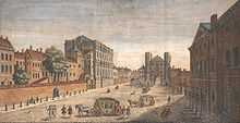
In 1799 many of the sites now occupied by large government buildings were covered with terraced houses
-

Horse Guards from Whitehall, 1836
-

The former Cox & Co Bank (1884–86), Whitehall, designed by Ewan Christian (1814–95) whose offices were nearby in Whitehall Place, the lower extension to the corner of Craig's Court is of 1900, designed by J. H. Christian, Ewan's cousin and a partner in his practice. Ewan Christian designed the National Portrait Gallery in St Martin's Place
See also
Notes
- ↑ John Michael Lee, George William Jones, June Burnham, At the Centre of Whitehall: Advising the Prime Minister and Cabinet, p. 42. St. Martin's Press, 1998. ISBN 0-312-17730-5
- ↑ http://www.thisislondon.co.uk/news/article-23404303-the-latest-terror-victims-whitehalls-trees.do
- ↑ http://www.bbc.co.uk/news/uk-england-london-24702806
Bibliography
- Whitehall Through the Centuries by George S Dugdale (Assistant at the London Museum) with black and white reproductions and plans. A foreword by Sir Edward Bridges. First published by Phoenix House (London) in 1950 with no ISBN.
- Brown, Colin (2009). Whitehall: The Street that Shaped a Nation. Simon & Schuster Ltd. ISBN 978-1-84737-077-8
- Stone to Build London: Portland's Legacy, Gill Hackman,Folly Books, Monkton Farleigh, 2014, ISBN978-0-9564405-9-4. Book includes details of many of the Portland stone buildings in Whitehall, including the Cenotaph, Banqueting House, Horse Guards, Foreign and Commonwealth Office and Ministry of Defence.
External links
| Wikimedia Commons has media related to Whitehall. |
- Aerial photo and map
- Whitehall in 1669, showing the Banqueting House and Holbein Gateway
- History of the Whitehall Theatre built on Whitehall in 1930
| ||||||||||||||||||||||||||||||||||||||||||||||||||||||||||||||||||||||||||||||||||||||||||||||||||||