White Mountain (Wyoming)
| White Mountain | |
|---|---|
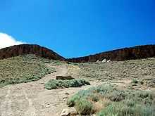
 White Mountain's highest point (minus Pilot Butte) located near Rock Springs, Wyoming | |
| Elevation | 7,623 ft (2,323 m) |
| Location | |
| Location | Sweetwater County, Wyoming, U.S. |
| Coordinates | 41°34′41″N 109°19′12″W / 41.57806°N 109.32000°W |
| Climbing | |
| Easiest route | Roads from Rock Springs and Green River |

White Mountain is a long mountain located in central Sweetwater County, Wyoming, near the cities of Rock Springs and Green River. The mountain is part of the Green River Formation, and contains communications towers that serve a number of purposes. Hundreds of carved figures also dot the sandstone cliffs at the White Mountain Petroglyph site and range from 200 to 1000 years old. Pilot Butte, located on top of White Mountain, is accessible from roads on the mountain.
Geology
Like its neighbor, Wilkins Peak, White Mountain is a member of the Green River Formation, a formation of the intermontane Lake Gosiute environment during the Eocene epoch. White Mountain is part of the Rock Springs Uplift,[1] and some of the largest oil shale and trona beds in the region are located west of the mountain. White Mountain contains sediment from a subcategory of the Green River Formation, known as the Wilkins Peak Formation.[2][3]
The peak itself is 7,623 feet (2,323 m) in elevation and is located 5.4 miles (9 km) from Rock Springs, Wyoming and 8.85 miles (14 km) from Green River, Wyoming.
Communication uses
White Mountain houses communication radio towers for a number of local and regional uses. A tower for the radio station K299AG broadcasts a religious radio format on 107.7 FM. Programming on the station comes from KCSP-FM.[4] The local cable company, Sweetwater Television, owns the tallest tower, on the center of the mountain. This tower can be seen in the picture above. K28JU-D, the local PBS affiliate of KCWC-DT broadcasts from space on the tower as well, and as of August 2009, is the only television station broadcasting from White Mountain.[5] Located next to that tower are transmitters used by the local BLM office, as well as a tower for cellular telephones, owned by Union Wireless.[6]
On the side of the mountain facing Green River, two more radio towers are present. One of the towers is used for airport communications from a nearby airport. The other, owned by Verizon Wireless is used for cellular telephone transmissions.[7]

Pilot Butte

Pilot Butte is located directly on top of White Mountain, and was named by early travelers in the region as a signal that they were close to the Green River.[8] Pilot Butte is also a part of the Wild Horse tour, and several herds of wild horses have been spotted in the area.[9] The butte is the second highest point in the immediate region, the first being Aspen Mountain to the south. It is 7,949 feet (2,423 m) in elevation at its highest point. The butte can be hiked, and contains a steel ladder to assist in reaching the summit.[10]
References
- ↑ Alan Caroll: Green River, Department of Geology & Geophysics, University of Wisconsin-Madison
- ↑ Eugster, H.P.; Hardie, L.A. (1975). "Sedimentation in an ancient playa-lake complex; the Wilkins Peak Member of the Green River Formation of Wyoming". Bulletin of the Geological Society of America 86 (3): 319–334. doi:10.1130/0016-7606(1975)86<319:SIAAPC>2.0.CO;2. Retrieved 2008-04-20.
- ↑ "Green River Formation". University of California Museum of Paleontology. Retrieved 2008-04-19.
- ↑ Radio-locator Query for K299AG
- ↑ http://www.fcc.gov/fcc-bin/tvq?list=0&facid=167610
- ↑ White Mountain, Rock Springs Side
- ↑ White Mountain, Green River Side
- ↑ Wyoming Places Wiki / Pilot Butte
- ↑ Wyoming Wild Horses - Pilot Butte Scenic Loop Tour
- ↑ A Little Grace: Hiking up Pilot Butte, Wyoming
External links
| ||||||||||||||||||||||||||