Wheatland Township, Ellis County, Kansas
| Wheatland Township | |
|---|---|
| Township | |
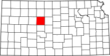
 Location in Ellis County | |
| Coordinates: 38°45′44″N 099°15′50″W / 38.76222°N 99.26389°WCoordinates: 38°45′44″N 099°15′50″W / 38.76222°N 99.26389°W | |
| Country | United States |
| State | Kansas |
| County | Ellis |
| Area | |
| • Total | 54.05 sq mi (139.98 km2) |
| • Land | 54.05 sq mi (139.98 km2) |
| • Water | 0 sq mi (0 km2) 0% |
| Elevation | 1,988 ft (606 m) |
| Population (2000) | |
| • Total | 401 |
| • Density | 7.4/sq mi (2.9/km2) |
| GNIS feature ID | 0475294 |
Wheatland Township is a township in Ellis County, Kansas, USA. As of the 2000 census, its population was 401.
Geography
Wheatland Township covers an area of 54.05 square miles (140.0 km2) and contains no incorporated settlements. According to the USGS, it contains one cemetery, Saint Francis.
The streams of Big Timber Creek and Shelter Creek run through this township.
Transportation
Wheatland Township contains two airports or landing strips: Philip Ranch Airport and Stecklein Field.
References
External links
| |||||||||||||||||||||||||||||