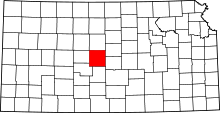
Wheatland Township, Barton County, Kansas
| Wheatland Township | |
|---|---|
| Township | |
 Location in Barton County | |
| Coordinates: 38°39′08″N 098°52′03″W / 38.65222°N 98.86750°WCoordinates: 38°39′08″N 098°52′03″W / 38.65222°N 98.86750°W | |
| Country | United States |
| State | Kansas |
| County | Barton |
| Area | |
| • Total | 36.21 sq mi (93.78 km2) |
| • Land | 36.16 sq mi (93.65 km2) |
| • Water | 0.05 sq mi (0.13 km2) 0.14% |
| Elevation | 1,952 ft (595 m) |
| Population (2010) | |
| • Total | 53 |
| • Density | 1.5/sq mi (0.57/km2) |
| GNIS feature ID | 0475403 |
Wheatland Township is a township in Barton County, Kansas, United States. As of the 2010 census, its population was 53.[1]
Wheatland Township was organized in 1878.[2]
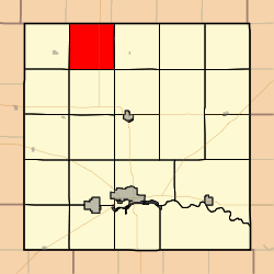
Geography
Wheatland Township covers an area of 36.21 square miles (93.8 km2) and contains no incorporated settlements. According to the USGS, it contains two cemeteries: Schneider and Schoenfeld.
References
- ↑ "Profile of General Population and Housing Characteristics: 2010 Demographic Profile Data (DP-1): Wheatland township, Barton County, Kansas". U.S. Census Bureau, American Factfinder. Retrieved July 13, 2012.
- ↑ History of the State of Kansas: Containing a Full Account of Its Growth from an Uninhabited Territory to a Wealthy and Important State. A. T. Andreas. 1883. p. 762.
External links
| |||||||||||||||||||||||||||||