Wharram Percy

Wharram Percy is a deserted medieval village (DMV) on the western edge of the chalk Wolds of North Yorkshire, England. It is about 1 mile (1.6 km) south of Wharram-le-Street and is signposted from the B1248 Beverley to Malton road. grid reference SE858646. Wharram Percy was part of the East Riding of Yorkshire until the 1974 boundary changes.
Wharram Percy may be the best-known DMV in the whole of England, although there are several others in a similarly good state of preservation. The reason for its notability is that it was researched each summer by combined teams of archaeologists, historians and even botanists, from about 1950 to 1990 after its identification in 1948 by Professor Maurice Beresford of the University of Leeds.
Although the site seems to have been settled since prehistory, the village seems to have been most active from the 10th to the 12th centuries. The Domesday Book of 1086 records it as Warran or Warron. The Black Death of 1348–49 does not seem to have played a significant part in the desertion of Wharram Percy although the large fall in population in the country as a whole at that time must have made relocation to a less remote spot more likely. The villagers of Wharram Percy seem to have suffered instead from changes in prices and wages in the 15th century, which gave pastoral farming (particularly of sheep) an advantage over traditional cereal farming. The village was finally abandoned in the early 16th century when the lord of the manor turned out the last few families and had their homes demolished to make room for more sheep pasture.
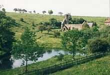
The site is now in the care of Historic England. Although only the ruined church is easily visible above ground, much more of the village layout can be seen in the surrounding fields. English Heritage installed new panels around the site, as well as an audio tour downloadable, in MP3 format, from the English Heritage website. A guidebook is available from surrounding, staffed, Historic England sites.
A scientific study published in 2004[1] of human skeletal remains from the deserted village reveals details of disease, diet and death in a rural medieval community.
A Tracker Pack for families that covers the site can be hired from Malton Tourist Information Centre.
The Yorkshire Wolds Way National Trail and the Centenary Way, long-distance footpaths pass to the east of the village.
References
Further reading
- Wrathmell, Susan (1996). Wharram Percy: Deserted Medieval Village. ISBN 978-1-85074-620-1.
External links
| Wikimedia Commons has media related to Wharram Percy. |
- Wharram Percy in the Domesday Book
- Wharram Percy by the former chief guide of the Beresford excavation
- English Heritage - History of Wharram Percy
- Investigation history
- English Heritage's investigation of the site in 2002
- Lost Village Sites of Yorkshire: Wharram Percy
- Abandoned communities ..... Wharram Percy
- BBC Radio 4 programme on Wharram Percy