Westwood, Los Angeles
| Westwood | |
|---|---|
| Neighborhood of Los Angeles | |
|
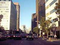
High-rise buildings line Wilshire Boulevard through the Westwood area | |
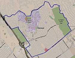 Westwood neighborhood as delineated by the Los Angeles Times. Mormon Temple in red. | |
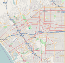 Westwood Location within Western Los Angeles | |
| Coordinates: 34°03′22″N 118°25′47″W / 34.05611°N 118.42972°W |
Westwood is a commercial and residential neighborhood in the northern central portion of the Westside region of Los Angeles, California. It is the home of the University of California, Los Angeles (UCLA).
The 2000 census found that the forty-seven thousand people living in the neighborhood were generally young and moderately diverse ethnically, with a generally high level of income and education.
The neighborhood was developed after 1919, with a new campus of the University of California being built and opened in 1926. Other attractions besides the UCLA campus include Westwood Village, with its historic motion picture theaters, restaurants and shopping, Westwood Village Memorial Park Cemetery and the Hammer Museum. Holmby Hills is considered one of the wealthiest residential areas in Los Angeles, and the Geffen Playhouse attracts theater-goers. A Mormon temple is also prominent.
There are several elementary schools and one middle school in the neighborhood.
Population
The 2010 U.S. census counted 56,735 residents in the 3.68-square-mile Westwood neighborhood—or 13,036 people per square mile, an average population density for the city. In 2008, the city estimated that the population had increased to 52,041. The median age for residents was 27, considered young for the city; the percentages of residents aged 19 to 34 was among the county's highest.[1]
The neighborhood was considered moderately diverse ethnically, with a high percentage of Asians and of whites. The breakdown was whites, 62.9%; Asians, 23.1%; Latinos, 7.0%; blacks, 2.0%; and others, 4.9%. Iran (23.5%) and Taiwan (7.3%) were the most common places of birth for the 31.3% of the residents who were born abroad—about the same percentage as in the city at large.[1]
The median yearly household income in 2008 dollars was $68,716, a high figure for Los Angeles. The percentages of households that earned $125,000 yearly and higher or that earned $20,000 or less were high for Los Angeles County. The average household size of two people was low for Los Angeles. Renters occupied 64.1% of the housing stock and house- or apartment owners held 35.9%. The percentages of never-married men and women were among the county's highest. In 2000 there were 309 families headed by single parents, a low percentage for the city. Five percent of the population had served in the military, a low figure for both the city and the county.[1]
Geography
According to the Westwood Neighborhood Council, the Westwood Homeowners Association, and the Los Angeles Times' Mapping L.A. project, Westwood's street and other boundaries are north, Sunset Boulevard; east, Beverly Hills city limits (to include the Los Angeles Country Club); south, Santa Monica Boulevard; and west, the San Diego Freeway (excluding the federal Veterans Administration grounds).[1][2]
Westwood is flanked on the north by Beverly Crest, on the east by Beverly Hills, on the southeast by Century City, on the south by West Los Angeles, on the west by Veterans Administration and Brentwood and on the northwest by Bel-Air.[3] The southern portion of Holmby Hills is also part of the Westwood district.[1]
History
Westwood was developed on the lands of the historic Wolfskill Ranch, a 3,000-acre (12 km2) parcel that was purchased by Arthur Letts, the successful founder of the Broadway, and Bullock's department stores, in 1919. Upon Arthur Lett's death, his son-in-law, Harold Janss, vice president of Janss Investment Company, inherited the land and developed the area and started advertising for new homes in 1922.
The Los Angeles Times reported the news: "Westwood, the subdivision of the Wolfskill Ranch, 3,300 acres (13 km2) of scenic territory between the city and Santa Monica, is to be opened to homeseekers and investors today by the Janss Investment Company. The tract comprises approximately 1000 residential and business lots, situated west of the Los Angeles Country Club on Santa Monica Boulevard and the Rancho Country Club on Pico Boulevard."[4]
Meanwhile, the Southern Branch of the University of California had been established on Vermont Avenue in Los Angeles, where enrollment expanded so rapidly that by 1925 the institution had outgrown the site. The selection of a new campus in the Westwood hills was announced on March 21, 1925. The owners of the estate, the Janss brothers, agreed to sell the property for approximately $1 million, less than one-third the land's value. Municipal bond measures passed by Los Angeles, Santa Monica, Beverly Hills and Venice provided for that amount. Proposition 10, a state bond measure passed that year, provided $3 million for new campus construction. Thus the predecessor of the University of California, Los Angeles, was established in Westwood and opened in 1926.
Attractions
A center of movie-going on the Westside and the site of many movie premieres, Westwood is home to several vintage movie theaters, including the Art Deco Crest, the Mann Village (once called the Fox Theater) featuring a landmark 170-foot (52 m) white tower and the Bruin Theatre. The Bruin Theatre provides a special discount to UCLA students. Playboy Mansion, home of Playboy founder Hugh Hefner, is located in Holmby Hills.
Westwood is also home to the Westwood Village Memorial Park Cemetery, the final resting place of many of Hollywood's biggest stars. A museum named for and endowed by activist and philanthropist Armand Hammer, longtime head of Occidental Petroleum (which maintains its headquarters on Wilshire Boulevard), has become one of Los Angeles' trendiest cultural attractions since UCLA assumed its management in the 1990s. The Hammer, as it is commonly known, is particularly notable for its collection of Impressionist art and cutting-edge modern art exhibitions. The museum also houses the Billy Wilder Theater, run by the UCLA Film and Television Archive.
Westwood Village
Built by the Janss Investment Company, the Westwood Village shopping district, which opened in 1929, retained its small-village atmosphere even after the San Diego Freeway came through the area in the 1950s and high-rise office towers went up around it in the following decades. However, much of this construction was planned around the never-built Beverly Hills Freeway; in combination with a perceived parking shortage at UCLA, high-density development in Westwood has created some of the worst traffic congestion in Los Angeles. Even with the opening of numerous municipal parking structures in the 1990s and 2000s (decade), finding a parking spot in Westwood Village is still a notoriously difficult task. With the proximity of Westwood's towering business area to its shops that line the streets around UCLA, parking and traffic issues dominate local planning debates.
Some landmark buildings still remain from the early years of Westwood Village including the first building erected in the village, the Janss Investment Company Building (Janss Dome) with its aqua and white zig-zag patterned dome and gold leafing. Other buildings listed as Historic-Cultural Monuments include the Fox and Bruin Theaters and the Ralphs Grocery Store building.
Westwood Village is within walking distance of the UCLA campus. There is a multitude of culturally-based restaurants condensed into this small area, so that students and Westwood visitors can choose from a variety of food options, including Indian, Chinese, Thai, American, Italian, Persian, Japanese, and Mexican.
Gangs
The shooting death of innocent bystander Karen Toshima, during a gun battle between rival gangs on January 30, 1988, gained nationwide notoriety[5] and led to the widespread impression that even affluent Westwood was not immune to the crime wave then ravaging Los Angeles. It would take more than a decade for this perception to fade.[6][7]
Geffen Playhouse
The Geffen Playhouse was built in 1929 at 10886 LeConte Avenue as the Masonic Affiliates Club, or the MAC, for students and alumni at UCLA. One of the first dozen structures built in Westwood Village, it was designed by architect Stiles O. Clements.[8][9]
Holmby Hills
Holmby Hills, Bel Air, and Beverly Hills form the "Platinum Triangle" of Los Angeles. It is bordered by the city of Beverly Hills on the east, Wilshire Boulevard on the south and Bel Air on the north.[10][11]
LDS (Mormon) Temple
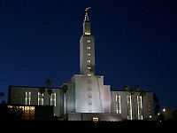
The Los Angeles California Temple, the second-largest temple operated by The Church of Jesus Christ of Latter-day Saints, is on Santa Monica Boulevard in Westwood. The temple grounds also includes a Visitors' Center open to the public and the headquarters for the Church's missionary efforts in Los Angeles. The church purchased the land for the temple from silent film star Harold Lloyd in 1937, but did not open the temple until 1956.
The temple grounds are also home to the Los Angeles Regional Family History Center (LARFHC), which is open to the public as well. It is the second-largest branch in the Family History Library system of the LDS Church, and contains more than 100,000 microfiche and 30,000 books.
-
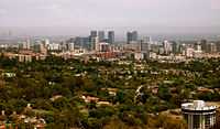
View of Westwood and surrounding areas
-
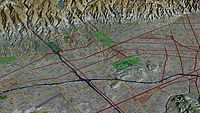
Aerial view of Westwood (center) and vicinity (3D computer generated image)
-
Hammer Museum of UCLA
-
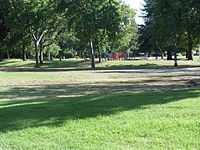
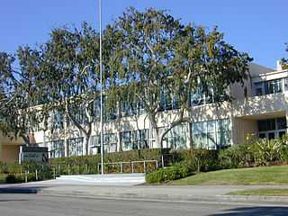
Westwood Park
Economy
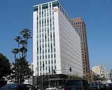
Occidental Petroleum had its headquarters in Westwood.[12][13]
Government and infrastructure
The Los Angeles County Department of Health Services SPA 5 West Area Health Office serves Westwood.[14]
Education
Sixty-six percent of Westwood residents aged 25 and older had earned a four-year degree by 2000, a high figure for both the city and the county. The percentages of residents of that age with a master's degree or higher was the third-highest in the county.[1][15]
Schools in Westwood are:
- Fairburn Avenue Elementary School, LAUSD, 1403 Fairburn Avenue
- Warner Avenue Elementary School, LAUSD, 615 Holmby Avenue
- Sinai Akiba Academy, private elementary, 10400 Wilshire Boulevard
- Saint Paul the Apostle, private elementary, 1536 Selby Avenue
- Ralph Waldo Emerson Middle School, LAUSD, 1660 Selby Avenue
UCLA Lab School Corinne A. Seeds Campus, formerly the Corinne A. Seeds University Elementary School and renamed in 2009, is the University of California, Los Angeles laboratory school.[16]
-
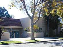
Fairburn Avenue School
-
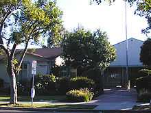
Warner Avenue School
-
Emerson Middle School
Parks and Recreation
The Westwood Recreation Center is in Westwood. The facility includes barbecue pits, a lighted baseball diamond, lighted outdoor basketball courts, racquetball courts, a children's play area, a community room, an indoor gymnasium with weights, and a picnic table. The center also has Aidan's Place, which opened on December 5, 2001. The place, named after wheelchair-bound Aidan James, is a playground developed for joint use by handicapped and non-handicapped children.[17][18]
Holmby Park is also in Westwood.
Emergency services
Police
The Los Angeles Police Department operates the West Los Angeles Community Police Station at 1663 Butler Avenue, which serves the community.[19] Law enforcement for the UCLA campus is the responsibility of the UCLA Police Department, a division of the independent, statewide University of California Police Department.[20] As a state police agency, the UCLA PD has full law enforcement powers on and off campus.[20]
Fire and EMS
Fire and emergency medical services are provided by the Los Angeles Fire Department. UCLA Emergency Medical Services, a division of the UCLA Police Department, operates a Basic Life Support ambulance for the UCLA campus and supports LAFD on medical aid calls in the surrounding community.[21] UCLA also maintains a small fire suppression apparatus staffed by campus fire marshals that responds to university-owned properties and assists the outside community when requested to by LAFD.
See also
References
- ↑ 1.0 1.1 1.2 1.3 1.4 1.5 "Westwood," Mapping L.A., Los Angeles Times
- ↑ The Thomas Guide: Los Angeles County, 2004, pages 631 and 632
- ↑ Colored map, Mapping L.A., Los Angeles Times
- ↑ "Westwood Is Placed on the Market." Los Angeles Times. October 29, 1922. p. V9
- ↑ Carlson, Margaret B. (February 22, 1988). "The price of life in Los Angeles; is one killing in Westwood worse than hundreds in the ghetto?". Time. p. 31.
- ↑ Glionna, John M. (January 30, 1998). "A murder that woke up L.A.". Los Angeles Times. pp. A1.
- ↑ Reinhold, Robert B. (February 8, 1988). "Gang Violence Shocks Los Angeles". New York Times.
- ↑ Geffen Playhouse - Westwood, retrieved 2007-02-22
- ↑ Mapquest
- ↑ H. May Spitz, A grander scale of life left intact, The Los Angeles Times, September 05, 2004
- ↑ King, Danny (September 1, 2003). "Projects move forward on Westwood's Golden Mile". Los Angeles Business Journal. p. 3.
- ↑ "Contact Us." Occidental Petroleum Corporation. Retrieved on December 8, 2011. "Corporate Headquarters 10889 Wilshire Boulevard Los Angeles, California 90024-4201 "
- ↑ Hsu, Tiffany. "Occidental's profit soars 53% to record high on surging oil prices." Los Angeles Times. April 25, 2008. C3. Retrieved on December 8, 2011. "Westwood-based Occidental Petroleum Corp."
- ↑ "About Us." Los Angeles County Department of Health Services. Retrieved on March 18, 2010.
- ↑ "Rankings," Mapping L.A.
- ↑ "Famed UCLA elementary school gets new name." Los Angeles Times. March 10, 2009. Retrieved on March 29, 2014.
- ↑ "Westwood Recreation Center." City of Los Angeles. Retrieved on March 19, 2010.
- ↑ "Universally Accessible Playgrounds." City of Los Angeles. Retrieved on March 19, 2010.
- ↑
- ↑ 20.0 20.1 UCLA Police Department Uniformed Patrol Division – Overview of Patrol Operations
- ↑ UCLA EMS official website
External links
| Wikimedia Commons has media related to Westwood, Los Angeles. |
- Comments about living in Westwood
- Westwood crime map and statistics
- History of Westwood Village – Old Postcards
- Birds of Westwood – A guide to birds found on and near the UCLA campus
- Los Angeles Times, Real Estate section, Neighborly Advice column: "[Wilshire Corridor:] "Mini-Manhattan, just west of Los Angeles" (November 14, 2004)
- Los Angeles Times, Real Estate section, Neighborly Advice column: "[Westwood:] That Westside college town" (September 7, 2003)
 |
Bel-Air | Beverly Crest | Los Angeles Country Club | |
| Veterans Administration & Brentwood | |
Beverly Hills | ||
| ||||
| | ||||
| Sawtelle | West Los Angeles | Century City |
| |||||||||||||||||
| |||||||||||||||||||||
Coordinates: 34°03′22″N 118°25′47″W / 34.05611°N 118.42972°W