Weston, Portland, Dorset

Coordinates: 50°32′23″N 2°26′50″W / 50.53971°N 2.44729°W
Weston is a village in Tophill on the Isle of Portland, Dorset, England. It abuts the main village Easton, and is north of the village of Southwell. As with the rest of Portland's villages and settlements, Weston has been designated as a conservation area, as it is a place of special architectural and historic interest, given protection to ensure that people can continue to enjoy their character for years to come. The village was designated in 1994.[1][2]
History
In similarity with other settlements on Portland, Weston first flourished around a natural source of water. It remains most probable that the Romans first transformed many of Portland's springs into ponds and wells, while natural ponds would be enclosed and maintained from this period. A small watercourse at Weston saw the first residences at the village centre around the stream. Some residences had a personal cistern. Weston's main pond was situated at Weston Corner, which remained in use until the early 20th century. Unlike most Portland villages, the rural landscape of Weston, like Southwell, remained strong and unchanged over many centuries, largely as the village was set away from the island's main industrial activity.[3]
Portland's infamous history of smuggling saw the selling and trading of contraband in various island pubs. One particular example was the Lugger Inn, which is no longer in existence, but was once at Gypsy Lane in Weston. It was also the first to have glass pane windows on the entire island.[4]
During the 19th-century Portland saw a massive expansion within its population, directly due to the labour-demanding projects of building Portland's harbour breakwaters and the defensive Verne Citadel. This soon meant the island's current water supply via the natural springs was no longer able to cope with the increasing demand. Before the island's piped water supply arrived at the beginning of the 20th century, no settlement on the island had a good supply of water except Weston and Southwell. The projects also led to a major increase in population on the island. Weston village escaped large development to cater for the increase.
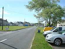
Weston's pond was filled in by 1906, following the piped water supply in 1901. The pond itself had become somewhat disregarded since the 1870s.[5] The site of the pond is now a wide grass verge, and until the 1970s The Prince Alfred Pub faced this section of the village. The pub was replaced by a row of modern houses, having last served in March 1973.[6][7] Weston's other pond was found on the other side of the village.
The year 1867 saw the establishment of the Easton and Church Hope Railway. The company's ambition was to create a line from Easton village to Church Ope Cove, though this proved unfeasible. Undeterred by the plan's failure the company obtained a second Act of Parliament in 1884, which allowed them to successfully extend the Weymouth to Portland Railway from Chiswell village at Underhill to Easton. The planned branch to the neighbouring Weston village never came to fruition, though the Easton branch began operating by the 20th century.[8] As a largely rural community many fields surrounding the village held cattle, but through the first half of the 20th century the fields were gradually being destroyed by inland quarrying.
The island did not gain mains electricity until 1930, as the local council continued to believe that the local gas works would finally become financially worthwhile. By 1930 an agreement had to be made, to bring across an electric supply generated from Weymouth. However the £25,000 scheme did not reach Weston or Southwell until 1932, following Underhill and Easton's supply.[9] From 1930 a demolition scheme by the local council threatened a considerable number of historical houses on the island. Despite strong local objection, much of the island's historic, Jacobean, Tudor and Georgian cottages would be demolished, rather than being restored. This included various dwellings at Weston. By the mid-20th century Weston was still a largely small village, but pressure on housing was reaching a new peak. From the 1960s onwards the original cottages of Weston were dominated by large housing estates. The main estate became known as Weston Estate, while other houses appeared between Weston and Easton. The Westcliff Housing Estate had been built for the Admiralty, and is now largely private. The housing estate of Haylands was built in the late 1960s, after the fields were last harvested in 1968. Through the 1970s, the Weston Estate continued to expand towards the western cliffs at Blacknor Point.[10] Despite this Weston is still set amongst expansive fields to the east and south.[11]
Features
The village features a small number of commercial business based along the main Weston Road. This includes a sweet store Just Sweets, previously known as Cards 'n' Candy,[12] a Co-Operative store,[13] the Codfathers takeaway,[14] The Royal Exchange pub[15] and L'n'O's Bistro.[16]
On the east side of Weston Road is the Royal Manor Arts College, which was Portland's only secondary school. It became a campus of the Isle of Portland Aldridge Community Academy in 2012. It closed in 2014 along with other schools on the island, all to be replaced by a new school situated at Southwell Business Park. On this side of the road an ancient stone-walled Sheep Pound still stands, which was used by the Court Leet to impound straying sheep and cattle. The pound was moved to its present roadside green position in 1950 when the nearby housing estate of 100 houses - Pound Piece - was built on the other side of the road.[17]
In the mid-19th century, two chapels were built within the village. This was due to the two Methodist communities unwilling to share the same premises. The Wesleyan chapel was first to open at Weston Road in 1858, and by 1860 the Primitives' chapel was situated at Weston Street. The Weston Road chapel is now the Weston Community Hall, and is also the headquarters of the Portland Scouts and Guides.[18]
Along the high West Cliff on the seaward side of Weston Estate, Blacknor Fort was built as a heavy gun emplacement. The fort was originally built around 1902 and the stronghold was equipped during both World Wars. During the second World War on the night of 27 April 1944, the gunners of the fort witnessed Nazi E-boats which attacked landing craft full of American soldiers on exercise in Lyme Bay. The fort was ordered not to fire for fear of hitting the men in the water. The Slapton Sands Massacre, as it became known, saw more than 600 American soldiers and seamen drowned by the end of the night.[19] The fort is now converted into a private clifftop residence.[20] Further south, on the edge of the estate once stood ROC Post Portland Bill, which was operational from 1960 to 1991, and was demolished circa 2008.[21] The high cliffs around this area are popular with rock climbers.[22]
To the north is Reforne, Easton, which holds St George's Church and St George's Centre - the former which can be seen from Weston. Close to the church, within Weston, is Portland's only public cemetery. To the east of the village, and near Easton, are the two Portland Windmills. The disused and historic stone towers date from as early as 1608 when they were first recorded in the Land Revenue Accounts. Both windmills have been separate Grade II Listed monuments since September 1978, and are the only historic windmill remains to survive in Dorset.[23][24]
To the far south of Weston village was a World War II pillbox, on a public footpath known as Barleycrates Lane. It was possibly hexagonal in plan, built of concrete and was constructed sometime between 1940-41. However no traces of the structure remain today.[25] As with many of Portland's pillboxes and heavy anti-aircraft batteries, this structure would probably have been built by local quarrymen.
Roman Villa
On the west side of Weston Road, opposite the Royal Manor School, is one of the few archaeological sites on the Isle of Portland. Remains of what is likely to be a Roman villa and high quality medieval building remains have been discovered. Around 2004 excavations for a new school sports pitch revealed the remains of the large multi-period complex. The sports area was relocated to enable a major archaeological dig to be undertaken.[17] The ruins dating from the Iron Age, Roman and Medieval periods were unearthed during the topsoil clearance. As a result, the council commissioned an in-depth examination of the area to discover more about the finds. Since then the site has been excavated and various discoveries have been reported.[26]
Within the same field there was once a Second World War pillbox. It was possibly hexagonal in plan, built of concrete and was constructed sometime between 1940-41. Today there are no traces of the structure.[27] In the same area was also a World War II air raid shelter.[28] Three others, all no longer in existence, were found where the school now stands.[29][30][31]
Grade listed features
Weston has a wide array of architecture and buildings, a number of which are Grade Listed.
High Croft Cottage (51 Providence Place) is a small detached house, dating from the 17th century but much altered in both the 19th and 20th centuries. It has been Grade II Listed since January 1951.[32] 53 Providence Place dates from 1850 and is one of the few dwellings in Weston not substantially modified externally. It has been Grade II Listed since May 1993.[33]
On Weston Road, Wanganui Cottage (71 Weston Road) has late 17th century or early 18th century origins, however was much modified in the 19th and 20th centuries. The dwelling probably formed part of a larger late 16th century house, now in several units, best represented by No. 72 adjoining. It became Grade II Listed in September 1978.[34] 82-84 Weston Road, along with its attached wall, became Grade II Listed at the same time. It has late 16th century/early 17th century origins, and was also much modified in the 19th and 20th centuries. The house was formerly two properties.[35] 64 Weston Road and its attached wall, date from the late 17th or early 18th centuries. The house is modest, but an important survival of a small house in a historic row which has undergone substantial changes in the 20th century. It became Grade II Listed in September 1978.[36] 72 Weston Road was designated Grade II in January 1953. The house, part of a row, was probably once the main wing of an original great house. It dates from the late 16th or early 17th century. When Nos. 68, 70, 80 and 82 were demolished, No. 72 formed a larger free-standing house when first built, but has now become a series of small units, probably in the 19th century. By the end of the 20th century it remained in poor condition, and in 1991 the property was fully restored with care, employing surviving historical features where possible.[37]
The row of houses consisting of 44, 44A, 46, and 48 Weston Street all make up what was once a farmhouse, dating from the early 19th century. The houses all became Grade II Listed in May 1993. The row remains a well retained ensemble, which until the late 20th century remained a farm, with row of arcaded farm outbuildings to its left end. These were also converted.[38]
References
- ↑ https://www.dorsetforyou.com/416983
- ↑ https://www.dorsetforyou.com/media/199172/Portland-conservation-area-appraisal/pdf/Appraisal_of_the_Conservation_Areas_of_Portland.pdf
- ↑ Morris, Stuart (1985). Portland: An Illustrated History. Dovecote Press. p. 88. ISBN 978-0946159345.
- ↑ Morris, Stuart (1985). Portland: An Illustrated History. Dovecote Press. p. 61. ISBN 978-0946159345.
- ↑ Morris, Stuart (1990). Portland Camera. Dovecote Press. pp. Photo 74. ISBN 978-0946159796.
- ↑ "Portland Archive Pictures". Isleofportlandpictures.org.uk. Retrieved 2012-09-16.
- ↑ Free Portland News. March 2013. Missing or empty
|title=(help); - ↑ Morris, Stuart (1985). Portland: An Illustrated History. Dovecote Press. p. 113. ISBN 978-0946159345.
- ↑ Morris, Stuart (1985). Portland: An Illustrated History. Dovecote Press. p. 129. ISBN 978-0946159345.
- ↑ Morris, Stuart (1985). Portland: An Illustrated History. Dovecote Press. p. 146. ISBN 978-0946159345.
- ↑ "Weston Estate, Portland". Geoffkirby.co.uk. Retrieved 2012-09-16.
- ↑ United Kingdom. "Cards 'N' Candy - Confectioners Portland Dorset". Mylocalservices.co.uk. Retrieved 2012-09-16.
- ↑ "Co-Operative Group Ltd - Convenience Stores in Isle Of Portland DT5 2BY". 192.com. Retrieved 2012-09-16.
- ↑ "Codfathers Portland". Harbourguides.com. Retrieved 2012-09-16.
- ↑ "The Royal Exchange, Portland, Dorset, DT5 2BZ - pub details #". Beerintheevening.com. 2008-12-08. Retrieved 2012-09-16.
- ↑ "L'n'O's Bistro, Weston Road, Isle of Portland". Lnosbistro.eclipse.co.uk. 2012-07-04. Retrieved 2012-09-16.
- ↑ 17.0 17.1 "Royal Manor School, Portland, Dorset". Geoffkirby.co.uk. Retrieved 2012-09-16.
- ↑ Morris, Stuart (1985). Portland: An Illustrated History. Dovecote Press. p. 82. ISBN 978-0946159345.
- ↑ "Quick facts about the Jurassic Coast". Jurassiccoastline.com. 1944-04-27. Retrieved 2012-09-16.
- ↑ "Blacknor, Portland, Dorset". Geoffkirby.co.uk. Retrieved 2012-09-16.
- ↑ "Portland Bill Dorset". Subbrit.org.uk. Retrieved 2014-06-26.
- ↑ "Databases | Portland". Rockfax. Retrieved 2012-09-16.
- ↑ "1203067 - The National Heritage List for England | English Heritage". List.english-heritage.org.uk. Retrieved 2014-06-26.
- ↑ "1281885 - The National Heritage List for England | English Heritage". List.english-heritage.org.uk. Retrieved 2014-06-26.
- ↑ http://www.pastscape.org.uk/hob.aspx?hob_id=1420381&sort=2&type=&rational=a&class1=None&period=None&county=93347&district=93625&parish=93626&place=&recordsperpage=10&source=text&rtype=&rnumber=&p=17&move=n&nor=294&recfc=0
- ↑ The Megalithic Portal and Megalith Map. "More prehistoric discoveries on Portland : The Megalithic Portal and Megalith Map:". Megalithic.co.uk. Retrieved 2012-09-16.
- ↑ http://www.pastscape.org.uk/hob.aspx?hob_id=1420379&sort=2&type=&rational=a&class1=None&period=None&county=93347&district=93625&parish=93626&place=&recordsperpage=10&source=text&rtype=&rnumber=&p=17&move=n&nor=294&recfc=0
- ↑ http://www.pastscape.org.uk/hob.aspx?hob_id=1413191&sort=2&type=&rational=a&class1=None&period=None&county=93347&district=93625&parish=93626&place=&recordsperpage=10&source=text&rtype=&rnumber=&p=2&move=n&nor=294&recfc=0
- ↑ http://www.pastscape.org.uk/hob.aspx?hob_id=1413192&sort=2&type=&rational=a&class1=None&period=None&county=93347&district=93625&parish=93626&place=&recordsperpage=10&source=text&rtype=&rnumber=&p=2&move=n&nor=294&recfc=0
- ↑ http://www.pastscape.org.uk/hob.aspx?hob_id=1413193&sort=2&type=&rational=a&class1=None&period=None&county=93347&district=93625&parish=93626&place=&recordsperpage=10&source=text&rtype=&rnumber=&p=2&move=n&nor=294&recfc=0
- ↑ http://www.pastscape.org.uk/hob.aspx?hob_id=1413194&sort=2&type=&rational=a&class1=None&period=None&county=93347&district=93625&parish=93626&place=&recordsperpage=10&source=text&rtype=&rnumber=&p=2&move=n&nor=294&recfc=0
- ↑ "1203107 - The National Heritage List for England | English Heritage". List.english-heritage.org.uk. Retrieved 2014-06-26.
- ↑ "1203108 - The National Heritage List for England | English Heritage". List.english-heritage.org.uk. 1993-05-17. Retrieved 2014-06-26.
- ↑ "1203133 - The National Heritage List for England | English Heritage". List.english-heritage.org.uk. 1978-09-21. Retrieved 2014-06-26.
- ↑ "1203134 - The National Heritage List for England | English Heritage". List.english-heritage.org.uk. Retrieved 2014-06-26.
- ↑ "1206477 - The National Heritage List for England | English Heritage". List.english-heritage.org.uk. 1978-09-21. Retrieved 2014-06-26.
- ↑ "1206490 - The National Heritage List for England | English Heritage". List.english-heritage.org.uk. 1953-01-16. Retrieved 2014-06-26.
- ↑ "1206525 - The National Heritage List for England | English Heritage". List.english-heritage.org.uk. Retrieved 2014-06-26.
| ||||||||||||||||||||||||||||||||||||||||||||||||||||||||||||||||||