Westford, Vermont
| Westford, Vermont | |
|---|---|
| Town | |
 Westford, Vermont | |
| Coordinates: 44°35′55″N 72°59′52″W / 44.59861°N 72.99778°WCoordinates: 44°35′55″N 72°59′52″W / 44.59861°N 72.99778°W | |
| Country | United States |
| State | Vermont |
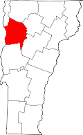
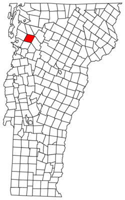
| County | Chittenden |
| Chartered | June 8, 1763 |
| Named for | Being the westernmost of four simultaneously granted New Hampshire Grants |
| Area | |
| • Total | 39.3 sq mi (101.8 km2) |
| • Land | 39.3 sq mi (101.7 km2) |
| • Water | 0.0 sq mi (0.1 km2) |
| Elevation | 472 ft (144 m) |
| Population (2010) | |
| • Total | 2,029 |
| • Density | 51.6/sq mi (19.9/km2) |
| Time zone | Eastern (EST) (UTC-5) |
| • Summer (DST) | EDT (UTC-4) |
| ZIP code | 05494 |
| Area code(s) | 802 |
| FIPS code | 50-80350[1] |
| GNIS feature ID | 1462251[2] |
Westford is a town in Chittenden County, Vermont, United States. The population was 2,087 at the 2000 census.
Geography
According to the United States Census Bureau, the town has a total area of 39.3 square miles (101.8 km2), of which 39.3 square miles (101.7 km2) is land and 0.04 square mile (0.1 km2) (0.08%) is water.
Demographics
As of the census[1] of 2010, there were 2029 people, 757 households, and 574 families residing in the town. The population density was 51.6 people per square mile (20.0/km2). There were 787 housing units at an average density of 20.0 per square mile (7.7/km2). The racial makeup of the town was 97.2% White, 0.3% African American, 0.4% Native American, 0.3% Asian, 0.2% from other races, and 1.5% from two or more races. Hispanic or Latino of any race were 0.8% of the population.
There were 757 households out of which 37.3% had children under the age of 18 living with them, 8.1% had a female householder with no husband present, and 24.2% were non-families. The average household size was 2.68 and the average family size was 3.00.
In the town the population was spread out with 26.6% under the age of 20, 3.9% from 20 to 24, 26.6% from 25 to 44, 33.9% from 45 to 64, and 8.8% who were 65 years of age or older. The median age was 41.5 years. For every 100 females there were 101.2 males. For every 100 females age 18 and over, there were 98 males.
The median income for a household in the town was $81,574, and the median income for a family was $84,423. Males had a median income of $55,417 versus $50,179 for females. The per capita income for the town was $34,502. About 1.0% of families and 1.7% of the population were below the poverty line, including 2.4% of those under age 18 and 3.7% of those age 65 or over.
Notable people
- Steven T. Byington (1869–1957), intellectual, translator, and American individualist anarchist born in Westford.[3]
- Philo Judson Farnsworth (1832–1909), physician born in Westford.[4]
- Paul Languedoc (b.1958), soundman for Vermont jam-band Phish. Languedoc lived in Westford on property that later became known as The Barn - the recording studio owned by Trey Anastasio[5]
- Jonathan Mann (b.1982), musician who grew up in Westford.[6]
- Luke P. Poland (1815–1887), United States Senator and Representative from Vermont born in Westford.[7]
- William Cleaver Wilkinson (1833–1920), Baptist preacher, professor of theology, professor of poetry, and literary figure born in Westford.[8]
References
- ↑ 1.0 1.1 "American FactFinder". United States Census Bureau. Retrieved 2008-01-31.
- ↑ "US Board on Geographic Names". United States Geological Survey. 2007-10-25. Retrieved 2008-01-31.
- ↑ Dalton, Bill (2008-07-17). "The Bard of Ballard Vale". Andover Townsman (North Andover, Massachusetts: Eagle-Tribune Publishing Company). Retrieved 2008-07-17.
- ↑ "Papers of Philo J. Farnsworth". University of Iowa Libraries: Special Collections and Archives. Retrieved 24 January 2012.
- ↑ Puterbaugh, Parke. "Phish: The Biography". Da Capo Press. P.96. 2010. ISBN 9780306819209
- ↑ https://www.facebook.com/songadaymann
- ↑ Luke P. Poland at the Biographical Directory of the United States Congress
- ↑ Burrage, Henry Sweetser. "Baptist Hymn Writers and Their Hymns". Brown Thurston. P.467. 1888.
External links
| |||||||||||||||||||||||||||||