Westfall, Oregon
| Westfall, Oregon | |
|---|---|
| Unincorporated community | |
 Westfall, Oregon | |
| Coordinates: 43°59′31″N 117°42′33″W / 43.99194°N 117.70917°WCoordinates: 43°59′31″N 117°42′33″W / 43.99194°N 117.70917°W | |
| Country | United States |
| State | Oregon |
| County | Malheur |
| Elevation | 2,995 ft (913 m) |
| Time zone | Pacific (PST) (UTC-8) |
| • Summer (DST) | PDT (UTC-7) |
| ZIP code | 97920 |
| Area code(s) | 541 |
| GNIS feature ID | 1136892[1] |
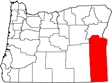
Westfall is an unincorporated community in Malheur County, Oregon, United States. Westfall is about 30 miles (48 km) west of Vale. Westfall has a post office with ZIP code 97920.[2]
Climate
According to the Köppen Climate Classification system, Westfall has a semi-arid climate, abbreviated "BSk" on climate maps.[3]
References
- ↑ "US Board on Geographic Names". United States Geological Survey. 2007-10-25. Retrieved 2008-01-31.
- ↑ ZIP Code Lookup
- ↑ Climate Summary for Westfall, Oregon
| |||||||||||||||||||||||||
