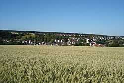
Westerstetten
| Westerstetten | ||
|---|---|---|
 | ||
| ||
 Westerstetten | ||
Location of Westerstetten within Alb-Donau-Kreis district 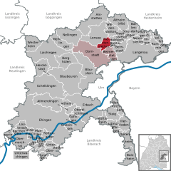
 | ||
| Coordinates: 48°31′13″N 9°57′19″E / 48.52028°N 9.95528°ECoordinates: 48°31′13″N 9°57′19″E / 48.52028°N 9.95528°E | ||
| Country | Germany | |
| State | Baden-Württemberg | |
| Admin. region | Tübingen | |
| District | Alb-Donau-Kreis | |
| Government | ||
| • Mayor | Hermann Krieger | |
| Area | ||
| • Total | 13.09 km2 (5.05 sq mi) | |
| Population (2012-12-31)[1] | ||
| • Total | 2,188 | |
| • Density | 170/km2 (430/sq mi) | |
| Time zone | CET/CEST (UTC+1/+2) | |
| Postal codes | 89198 | |
| Dialling codes | 0731, 07348 and 07336 | |
| Vehicle registration | UL | |
| Website | www.westerstetten.de | |

Westerstetten is a village in the district of Alb-Donau in Baden-Württemberg in Germany.
Geography
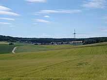
Westerstetten is situated in the Lone valley (Lonetal) in the Swabian Jura roughly 10 km (6 mi) north of Ulm.
Neighbouring Villages
The neighbouring villages are, to the east, Holzkirch and Breitingen; to the south, Beimerstetten; to the southwest, Dornstadt; and to the northwest, Lonsee.
Structure
Villages incorporated in Westerstetten are Birkhof, Hinterdenkental and Vorderdenkental.
History
Early history
The Lone valley with its caves was a popular settlement area in the Stone Age. Westerstetten itself however has no caves, and there have been no significant finds of this period.
Roman period
Since 75 AD a Roman road connected the Ad Lunam castle in Lonsee-Urspring with Aquilea at Heidenheim. As part of the Alblimes, this road marked for some time the external border for the Roman Empire.
1414 onwards
From 1414 to 1803, Westerstetten was part of the territory of Elchingen Abbey. When the abbey was dissolved in 1803 as part of the German Mediatisation, the village became part of Bavaria along with Elchingen. In 1810 the border between Bavaria and Württemberg was re-negotiated and Westerstetten became part of Württemberg.
At the end of the Second World War, Westerstetten was liberated by American troops in April 1945, after a few die-hards tried to stop the allies at the entrance to the village. According to local lore, the Jewish graves in the cemetery hold the bodies of eight Nazi concentration camp victims that were hastily buried in the Gurgelhaus forest, shortly before the end of the war.[2]
The local government reform of 1975 allowed Westerstetten to retain its independence. The designation of new building zones and its vicinity to Ulm helped it grow to over 2,000 inhabitants.
References
- ↑ "Gemeinden in Deutschland mit Bevölkerung am 31.12.2012 (Einwohnerzahlen auf Grundlage des Zensus 2011)". Statistisches Bundesamt (in German). 12 November 2013.
- ↑ Gedenkstätten für die Opfer des Nationalsozialismus. Eine Dokumentation, Band 1. Bundeszentrale für politische Bildung, Bonn 1995, ISBN 3-89331-208-0, pp. 104f.