Western Asia
| Western Asia | |
|---|---|
.svg.png) | |
| Area |
6,255,160 sq km (2,415,131 sq mi)a |
|
|
| Countries[1] | |
| Nominal GDP | $2.742 trillion (2010)b |
| GDP per capita | $8748 (2010)b |
| Time zones | UTC+2 to UTC+4:30 |
| Demonyn | West Asian |
| Languages | |
| Largest cities | |
| |
Western Asia, West Asia, Southwestern Asia or Southwest Asia is the westernmost subregion of Asia. Western Asia is a newer term for the area that encompasses the Middle East and the Near East. West Asia and Europe are collectively referred to as Western Eurasia.
History
Some of the world's earliest civilizations developed in Western Asia. For most of the last three millennia, the region has been united under one or two powerful states; each one succeeding the last, and at times, eastern and western based polities. The main states in this regard were the Assyrian Empire, the Babylonian Empire, the Achaemenid Empire, Ancient Israel, the Kingdom of Armenia, the Seleucid Empire, the Parthian Empire, the Roman Empire, the Sassanid Empire, the Byzantine Empire, the Umayyad Caliphate, the Abbasid Caliphate, the Safavid Empire, the Afsharid Empire, and the Ottoman Empire.
Geography
Western Asia is located directly south of Eastern Europe. The region is surrounded by seven major seas; the Aegean Sea, the Black Sea, the Caspian Sea,[2] the Persian Gulf,[3] the Arabian Sea, the Red Sea, and the Mediterranean Sea.
To the north, the region is delimited from Europe by the Caucasus Mountains, to the southwest, it is delimited from Africa by the Isthmus of Suez, while to the east, the region adjoins Central Asia and South Asia. The Dasht-e Kavir and Dasht-e Lut deserts in eastern Iran naturally delimit the region somewhat from Asia itself.
European geographers historically viewed the North Caucasus as part of Western Asia, as well as much of what is today European Russia.
Climate

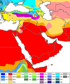
Western Asia is primarily arid and semi-arid, and can be subject to drought, but it also contains vast expanses of forest and fertile valleys. The region consists of grasslands, rangelands, deserts, and mountains. Water shortages are a problem in many parts of West Asia, with rapidly growing populations increasing demands for water, while salinization and pollution threaten water supplies.[4] Major rivers, including the Tigris and Euphrates, provide sources for irrigation water to support agriculture.
There are two wind phenomena in Western Asia: the sharqi and the shamal. The sharqi (or sharki) is a wind that comes from the south and southeast. It is seasonal, lasting from April to early June, and comes again between late September and November. The winds are dry and dusty, with occasional gusts up to 80 kilometers per hour (50 miles per hour) and often kick up violent sand and dust storms that can carry sand a few thousand meters high, and can close down airports for short periods of time. These winds can last for a full day at the beginning and end of the season, and for several days during the middle of the season. The shamal is a summer northwesterly wind blowing over Iraq and the Persian Gulf states (including Saudi Arabia and Kuwait), often strong during the day, but decreasing at night. This weather effect occurs anywhere from once to several times a year.[5]
Topography
Western Asia contains large areas of mountainous terrain. The Anatolian Plateau is sandwiched between the Pontus Mountains and Taurus Mountains in Turkey. Mount Ararat in Turkey rises to 5,137 meters. The Zagros Mountains are located in Iran, in areas along its border with Iraq. The Central Plateau of Iran is divided into two drainage basins. The northern basin is Dasht-e Kavir (Great Salt Desert), and Dasht-e-Lut is the southern basin.
In Yemen, elevations exceed 3,700 meters in many areas, and highland areas extend north along the Red Sea coast and north into Lebanon. A fault-zone also exists along the Red Sea, with continental rifting creating trough-like topography with areas located well-below sea level.[6] The Dead Sea, located on the border between the West Bank, Israel, and Jordan, is situated at 418 m (1371 ft) below sea level, making it the lowest point on the surface of the Earth.[7]
Rub' al Khali, one of the world's largest sand deserts, spans the southern third of the Arabian Peninsula in Saudi Arabia, parts of Oman, the United Arab Emirates and Yemen. Jebel al Akhdar is a small range of mountains located in northeastern Oman, bordering the Gulf of Oman.
Geology
Plate tectonics
Three major tectonic plates converge on Western Asia, including the African, Eurasian, and Arabian plates. The boundaries between the tectonic plates make up the Azores-Gibraltar Ridge, extending across North Africa, the Red Sea, and into Iran.[8] The Arabian Plate is moving northward into the Anatolian plate (Turkey) at the East Anatolian Fault,[9] and the boundary between the Aegean and Anatolian plate in eastern Turkey is also seismically active.[8]
Water resources
Several major aquifers provide water to large portions of Western Asia. In Saudi Arabia, two large aquifers of Palaeozoic and Triassic origins are located beneath the Jabal Tuwayq mountains and areas west to the Red Sea.[10] Cretaceous and Eocene-origin aquifers are located beneath large portions of central and eastern Saudi Arabia, including Wasia and Biyadh which contain amounts of both fresh water and saline water.[10] Flood or furrow irrigation, as well as sprinkler methods, are extensively used for irrigation, covering nearly 90,000 km² across Western Asia for agriculture.[11]
Demographics
The population of Western Asia is over 300 million. The most populous countries in the region are Iran and Turkey, each with around 75 million people, followed by Iraq with around 32 million people. The major languages are Arabic, which is an official language in 14 regional countries, followed by Turkish, and Persian. Islam is the major faith in Western Asia, followed by other Abrahamic religions, all of which originated in the region.
Economy
The economy of Western Asia is diverse and the region experiences high economic growth. Turkey has the largest economy in the region, followed by Saudi Arabia and Iran. Petroleum is the major industry in the regional economy, as more than half of the world's oil reserves and around 40 percent of the world's natural gas reserves are located in the region.
Definitions
United Nations Statistics Division

The UNSD department of the UN is the only organ that deviates from the commonly globally known definition of West Asia. However, the UNSD specifically notes that the "assignment of countries or areas to specific groupings is merely for statistical convenience and does not imply any assumption regarding political or other affiliation of countries or territories."[12] The countries and territories in the UNSD subregion of Western Asia,[13] listed below:
-
 Armenia
 -
 Azerbaijan
 -
 Bahrain
 -
 Cyprus
 -
 Egypt (Sinai Peninsula)
 -
 Georgia
 -
 Iran
Iran -
 Iraq
Iraq -
 Israel
 -
 Jordan
 -
 Kuwait
 -
 Lebanon
 -
 Oman
Oman -
 Palestine
 -
 Qatar
Qatar -
 Saudi Arabia
 -
 Syria
Syria -
 Turkey
 -
 United Arab Emirates
 -
 Yemen
Yemen
Though not included in the UNSD subregion of Western Asia, Iran is included within Western Asia by all other institutions, statistics and boards.[14][15]
The Sinai Peninsula of Egypt geographically belongs to Western Asia.
Government of Canada
The Government of Canada uses "West Asian" in its official statistics.[15]
General data
| Country, with flag | Area (km²) |
Population (2012) |
Density (per km²) |
Capital | Nominal GDP[16] (2012) |
Per capita[17] (2012) |
Currency | Government | Official languages | |
|---|---|---|---|---|---|---|---|---|---|---|
| Anatolia: | ||||||||||
| 783,562 | 73,722,988 | 94.1 | Ankara | $788.042 billion | $10,523 | Turkish lira | Parliamentary republic | Turkish | ||
| Arabian Peninsula: | ||||||||||
| |
665 | 1,234,596 | 1,646.1 | Manama | $30.355 billion | $26,368 | Bahraini dinar | Constitutional monarchy | Arabic | |
| |
17,820 | 3,566,437 | 167.5 | Kuwait City | $184.540 billion | $48,761 | Kuwaiti dinar | Constitutional monarchy | Arabic | |
| |
212,460 | 2,694,094 | 9.2 | Muscat | $78.290 billion | $25,356 | Omani rial | Absolute monarchy | Arabic | |
| |
11,437 | 1,696,563 | 123.2 | Doha | $192.402 billion | $104,756 | Qatari riyal | Absolute monarchy | Arabic | |
| |
2,149,690 | 27,136,977 | 12 | Riyadh | $733.956 billion | $25,139 | Saudi riyal | Absolute monarchy | Arabic | |
| |
82,880 | 8,264,070 | 97 | Abu Dhabi | $383.799 billion | $43,774 | UAE dirham | Federal Constitutional monarchy | Arabic | |
| |
527,970 | 23,580,000 | 44.7 | Sana'a | $35.05 billion | $1,354 | Yemeni rial | Presidential republic | Arabic | |
| South Caucasus: | ||||||||||
| 29,800 | 3,262,200 | 108.4 | Yerevan | $9.950 billion | $3,033 | Armenian dram | Presidential republic | Armenian | ||
| 86,600 | 9,165,000 | 105.8 | Baku | $68.700 billion | $7,439 | Azerbaijani manat | Presidential republic | Azerbaijani | ||
| |
69,700 | 4,636,400 | 68.1 | Tbilisi | $15.847 billion | $3,523 | Georgian lari | Semi-presidential republic | Georgian | |
| Fertile Crescent: | ||||||||||
| |
438,317 | 33,635,000 | 73.5 | Baghdad | $216.044 billion | $6,410 | Iraqi dinar | Parliamentary republic | Arabic, Kurdish | |
| |
20,770 | 7,653,600 | 365.3 | Jerusalem | $257.62 billion | $33,451 | Israeli new shekel | Parliamentary republic | Hebrew, Arabic | |
| |
92,300 | 6,318,677 | 68.4 | Amman | $30.98 billion | $4,843 | Jordanian dinar | Constitutional monarchy | Arabic | |
| |
10,452 | 4,228,000 | 404 | Beirut | $42.519 billion | $10,425 | Lebanese pound | Parliamentary republic | Arabic | |
| |
6,220 | 4,260,636 | 667 | Ramallah3 | $6.6 billion | $1,600 | Egyptian pound, Jordanian dinar, Israeli new shekel | Semi-presidential republic | Arabic | |
| |
185,180 | 23,695,000 | 118.3 | Damascus | n/a | n/a | Syrian pound | Presidential republic | Arabic | |
| Iranian Plateau: | ||||||||||
| |
1,648,195 | 78,868,711 | 45 | Tehran | $548.590 billion | $7,207 | Iranian rial | Islamic republic | Persian | |
| Mediterranean Sea: | ||||||||||
| |
9,250 | 1,088,503 | 117 | Nicosia | $22.995 billion | $26,377 | Euro | Presidential republic | Greek, Turkish | |
| Sinai Peninsula: | ||||||||||
| |
60,000 | 850,000 | 82 | Cairo | $262.26 billion | $3,179 | Egyptian pound | Presidential republic | Arabic | |
|
Notes: 1 The figures for Turkey includes East Thrace, which is not a part of Anatolia. | ||||||||||
Map of Western Asia

See also
- Cinema of West Asia
- List of World Heritage Sites in Western Asia
- West Asian Football Federation
- West Asian Games
References
- ↑ "CIA World Factbook: Middle East/West Asia". Retrieved 19 March 2015.
- ↑ Mughal, Muhammad Aurang Zeb.(201). "Caspian Sea." Robert Warren Howarth (ed.), Biomes & Ecosystems, Vol. 2. Ipswich, MA: Salem Press, pp. 431–433.
- ↑ Mughal, Muhammad Aurang Zeb. 2013. Persian Gulf Desert and Semi-desert. Robert Warren Howarth (ed.), Biomes & Ecosystems, Vol. 3. Ipswich, MA: Salem Press, pp. 1000–1002.
- ↑ "Chapter 7: Middle East and Arid Asia". IPCC Special Report on The Regional Impacts of Climate Change: An Assessment of Vulnerability. United Nations Environment Programme (UNEP), Intergovernmental Panel on Climate Change (IPCC). 2001.
- ↑ Taru Bahl; M H Syed, eds. (2003). Encyclopaedia of the Muslim World. New Delhi: Anmol Publications. p. 20. ISBN 978-81-261-1419-1. Retrieved 1 February 2009.
- ↑ Sweeney, Jerry J.; William R. Walter (December 1, 1998). "Region #4 — Red Sea Continental Rift Zone" (PDF). Preliminary Definition of Geophysical Regions for the Middle East and North Africa. Lawrence Livermore National Laboratory. p. 8.
- ↑ "ASTER Image Gallery: The Dead Sea". NASA.
- ↑ 8.0 8.1 Beaumont (1988), p. 22
- ↑ Muehlberger, Bill. "The Arabian Plate". NASA, Johnson Space Center.
- ↑ 10.0 10.1 Beaumont (1988), p. 86
- ↑ "Food and Agriculture Organization (FAO)".
- ↑ "Standard Country or Area Codes for Statistical Use". Millenniumindicators.un.org. Retrieved 2012-08-25.
- ↑ "United Nations Statistics Division- Standard Country and Area Codes Classifications (M49)". United Nations Statistics Division. 31 October 2013. Retrieved 2010-07-24.
- ↑ Style Committee (January 2011). "West Asia". National Geographic Style Manual. National Geographic Society.
- ↑ 15.0 15.1 "Ethnic Origin (247), Single and Multiple Ethnic Origin Responses (3) and Sex (3) for the Population of Canada, Provinces, Territories, Census Metropolitan Areas and Census Agglomerations, 2006 Census". Statistics Canada. 2006.
- ↑ "GDP". IMF. Retrieved 2014-04-16.
- ↑ "GDP per capita". IMF. Retrieved 2014-04-16.
External links
- Stanford's Map of Western Asia from 1885 by Edward Stanford
 |
Aegean Sea · Black Sea | |
Caspian Sea · |
|
| Mediterranean Sea | |
| ||
| ||||
| | ||||
| |
Red Sea · Gulf of Aden | Arabian Sea · |
| ||||||||||