Westend (Berlin)
| Westend | |
|---|---|
| Quarter of Berlin | |
|
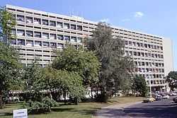
Unité d'Habitation | |
 Westend | |
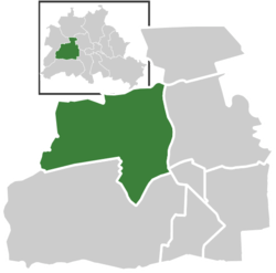
Location of Westend in Charlottenburg-Wilmersdorf and Berlin  | |
| Coordinates: 52°31′00″N 13°17′00″E / 52.51667°N 13.28333°ECoordinates: 52°31′00″N 13°17′00″E / 52.51667°N 13.28333°E | |
| Country | Germany |
| State | Berlin |
| City | Berlin |
| Borough | Charlottenburg-Wilmersdorf |
| Founded | 1866 |
| Area | |
| • Total | 13.5 km2 (5.2 sq mi) |
| Population (2008-06-30) | |
| • Total | 37,883 |
| • Density | 2,800/km2 (7,300/sq mi) |
| Time zone | CET/CEST (UTC+1/+2) |
| Postal codes | (nr. 0405) 14050, 14052, 14053, 14055, 14057, 14059 |
| Vehicle registration | B |
Westend is a locality of the Berlin borough Charlottenburg-Wilmersdorf. It emerged in the course of Berlin's 2001 administrative reform on the grounds of the former Charlottenburg borough.
Geography
Westend is situated west of Berlin's inner city on Spandauer Berg, the northern peak of the Teltow plateau between the river valleys of Spree and Havel. Originally a mansion colony, it is today a quite densely settled, still affluent territory adjacent to Charlottenburg in the east. It is centered around Theodor-Heuss-Platz, a large square, from where the Heerstraße arterial road runs westwards to the Berlin city limits. In the west and north, Westend borders on the Berlin Spandau borough.
The locality also includes the neighbourhoods of Neu-Westend and Ruhleben, a suburban housing area of the 1920s. The site of the former Ruhleben internment camp, a World War I detention camp for civilians, today is part of the adjacent Spandau district. Furthermore the areas of Pichelsberg, Heerstraße and Eichkamp at the northern rim of the Grunewald forest belong to Westend. It is home of the Berlin trade fair (where the Internationale Funkausstellung is held) and of the former Reichssportfeld area of the 1936 Summer Olympics.
History

When upon the 1806 Battle of Jena–Auerstedt victorious Napoleon moved into Berlin, he had a military camp set up on Spandauer Berg, though he himself chose nearby Charlottenburg Palace for accommodation. In May 1808 General Claude Victor-Perrin, French governor of Berlin, pitched the large Camp Napoleonbourg here, however, he folded up his tents already in November and wasteland was left behind. On the road from Charlottenburg to Spandau, the Spandauer Bock brewery was established in 1840, together with a popular pub catering though of doubtful reputation.
The surrounding area was developed from 1866 on as a residential area for the wealthy bourgeoisie of Berlin and named after the West End of London. Though a first land settlement company around the architect Martin Gropius collapsed in the Panic of 1873, the development was boosted by Berlin's population pressure. In 1889 a harness racing track opened, which was relocated to Ruhleben in 1908. Westend again became a garrison town, when in the 1890s the 3rd Brigade regiment No. 3 (Königin Elisabeth) barracks of the German 2nd Guards Infantry Division were erected on the eastern Spandauer Berg slope.
Sights
- Funkturm, erected in 1926
- Haus des Rundfunks by Hans Poelzig, 1931, today broadcasting centre of the Rundfunk Berlin-Brandenburg (RBB)
- Deutschlandhalle arena, 1935
- Messe Berlin arena, 1936/1937
- St. George's Anglican Church, 1950
- Epiphany Church, built in 1906 according to plans designed by Jürgen Kröger
- Olympic Stadium with Bell Tower (Glockenturm) and Waldbühne amphitheatre by Werner March, 1934–36
- Unité d'Habitation with Modulor scale by Le Corbusier, part of the Interbau exhibition 1957
- Studio of sculptor Georg Kolbe, 1929, with museum
- Internationales Congress Centrum (ICC), 1979
- Mommsen Stadium, 1930, home of the Tennis Borussia Berlin football club
- Westend hospital of the German Red Cross
- Spandauer Berg water tower, 1909
- Villas along the street Am Rupenhorn by Erich Mendelsohn, 1930 and Wassili and Hans Luckhardt, 1932
Transportation
Westend is served by the Berlin S-Bahn Ringbahn lines S41, S42 and S46 at the stations Westend, Messe Nord/ICC and Westkreuz as well as the Westbahn lines S75 and S5 at the stations Messe Süd, Heerstraße, Olympiastadion (Süd) and Pichelsberg.
U-Bahn connection to the inner city is provided by the U2 line with the stations Kaiserdamm, Theodor-Heuss-Platz, Neu-Westend, Olympia-Stadion (Ost) and Ruhleben.
The A100 (Berliner Stadtring) motorway marks Westend's eastern border. The federal highways Bundesstraße 2 and Bundesstraße 5 together run through the locality along the streets Kaiserdamm and Heerstraße. Near the S-Bahn station Messe Nord/ICC is Berlin's Central Bus station Zentraler Omnibusbahnhof (ZOB).
See also
External links
![]() Media related to Westend at Wikimedia Commons
Media related to Westend at Wikimedia Commons
| ||||||||||||||||||||||||||||||||||||||||||||||||||||||
