West Philadelphia Streetcar Suburb Historic District
|
West Philadelphia Streetcar Suburb Historic District | |
 | |
|
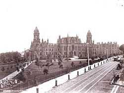
College Hall (and Logan Hall) viewed from Woodland Ave., ca. 1892. | |
 | |
| Location |
Roughly bounded by U. of Pennsylvania campus, Woodlands Cemetery, Poweltown Ave., 52nd St., & Woodland Ave. Philadelphia, Pennsylvania |
|---|---|
| Coordinates | 39°57′1″N 75°12′45″W / 39.95028°N 75.21250°WCoordinates: 39°57′1″N 75°12′45″W / 39.95028°N 75.21250°W |
| Area | 640 acres (260 ha) |
| Architect | multiple |
| Architectural style | Queen Anne, Colonial Revival, Classical Revival |
| Governing body | Local |
| NRHP Reference # | 97001669[1] |
| Added to NRHP | February 5, 1998 |
The West Philadelphia Streetcar Suburb Historic District is an area of West Philadelphia listed on the National Register of Historic Places because it represents the transformation of Philadelphia's rural farmland into urban residential development, made possible by the streetcar, which provided easy access to Center City.[2] This is an early example of the streetcar suburb.
Development had proceeded during the 19th century to about 43rd Street. The arrival of electrified streetcars in 1892 accelerated development to the west and southwest.[3][4]
Noted Philadelphia church architect Isaac Pursell (1853-1910) designed the contributing Christ Memorial Church (1887) at 4233-4257 Chestnut Street.[5]
See also
- Clark Park
- The Woodlands Cemetery
- Hamilton Village
- Woodland Terrace
References
- ↑ "National Register Information System". National Register of Historic Places. National Park Service. 2007-01-23.
- ↑ West Philadelphia Streetcar Suburb Historic District
- ↑ ""Studio 34's Eponymous Trolley, or, A Short History of Route 34"". Retrieved 2008-03-11.
- ↑ Rodin, Judith (2007). The University & Urban Revival. University of Pennsylvania. p. 26. ISBN 978-0-8122-4022-1.
- ↑ Seventh Annual Endangered Properties List, Preservation Matters: The Newsletter of The Preservation Alliance for Greater Philadelphia, Winter 2010
External links
- National Register
- Philadelphia Trolley Tracks: history and photos
- District Map
| |||||||||||||||||||||||||