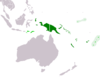
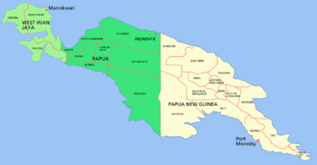
West Papua (region)
| West Papua | |
| Region | |
| Country | |
|---|---|
| Provinces | Papua, West Papua |
| Cities | Jayapura, Manokwari, Sorong, Wamena, Timika, Merauke |
| Highest point | Puncak Jaya |
| - location | Sudirman Range |
| - elevation | 4,884 m (16,024 ft) |
| - coordinates | 4°5′S 137°11′E / 4.083°S 137.183°E |
| Area | 420,540 km2 (162,371 sq mi) |
| Population | 4,363,869 (2014) |
| Density | 10 / km2 (26 / sq mi) |
| Timezone | WIT (Asia/Jayapura) (UTC+9) |
| ISO 3166-2 | ID-IJ |
| License plate | DS |
 | |
West Papua or Western New Guinea was annexed by Indonesia from the Netherlands in 1969 and is the western half of the island of New Guinea and smaller islands to its west. The region is administered as two provinces: Papua and West Papua. The eastern half of New Guinea is the country of Papua New Guinea. The population of approximately 3.6 million comprises ethnic Papuans, Melanesians, and Austronesians. The region is predominantly dense forest where numerous traditional tribes live such as the Dani of the Baliem Valley, although the majority of the population live in or near coastal areas. The largest city in the region is Jayapura. The official and most commonly spoken language is Indonesian. Estimates of the number of tribal languages in the region range from 200 to over 700, with the most widely spoken including Dani, Yali, Ekari and Biak. The predominant religion is Christianity (often combined with traditional beliefs) followed by Islam. The main industries include agriculture, fishing, oil production, and mining.
Human habitation is estimated to have begun between 42,000 and 48,000 years ago.[1] The Netherlands claimed the region and commenced missionary work in the nineteenth century. The region was forcibly annexed by Indonesia in the 1960s, and has faced a violent separatist movement since then. Following the 1998 commencement of reforms across Indonesia, Papua and other Indonesian provinces received greater regional autonomy. In 2001, "Special Autonomy" status was granted to Papua province, although to date, implementation has been partial.[2] The region was administered as a single province until 2003, when it was split into the provinces of Papua and West Papua.
Name
Speakers align themselves with a political orientation when choosing a name for the western half of the island of New Guinea.[3] "West Papua", which is not the official name for the western half of the island, is preferred by ethnic Papuans.[4][5] The region has had the official names of Netherlands New Guinea (1895–1962), West New Guinea (1962–63), West Irian (1963–73), Irian Jaya (1973–2001), and Papua (2002–2003). When the region was administratively one in Indonesia, Indonesian officials criticised activists' use of the term "West Papua", because they thought that the term implied that the province was not a part of Indonesia. Indonesian president Abdurrahman Wahid considered his short-lived use of the name "Papua" in 2002 as a concession to the West Papuans.[6] Since 2003, western New Guinea has had two provinces: the province of West Papua on the west, and the province of Papua on the east. Officials and administrators refer to the province when they say "West Papua"; independence activists mean the whole of western New Guinea.[7]
Geography
The region is 1,200 km from east to west and 736 km from north to south. It has an area of 420,540 km2 (162,371 sq mi), which equates to approximately 22% of Indonesia's land area. The border with Papua New Guinea mostly follows the 141st meridian east, with one section defined by the Fly River.[8]
The island of New Guinea was once part of the Australian landmass and lie on the Sahul. The collision between the Indo-Australian Plate and Pacific plate resulting in the Maoke Mountains run through the centre of the region and are 600 km (373 mi) long and 100 km (62 mi) across. The range includes about ten peaks over 4,000 metres (13,120 feet),[9] including Puncak Jaya (4,884 m), Puncak Mandala (4,760 m) and Puncak Trikora (4,750 m).[10] The range ensures a steady supply of rain from the tropical atmosphere. The tree line is around 4,000 m (13,100 ft) and the tallest peaks feature small glaciers and are snowbound year round. Both north and west of the central ranges the land remains mountainous — mostly 1,000 to 2,000 m (3,300–6,660 ft) high with a warm humid climate year round. The highland areas feature alpine grasslands, jagged bare peaks, montane forests, rainforests, fast flowing rivers, and gorges. Swamps and low-lying alluvial plains of fertile soil dominate the southeastern section around the town of Merauke. Swamps also extend 300 km around the Asmat region.
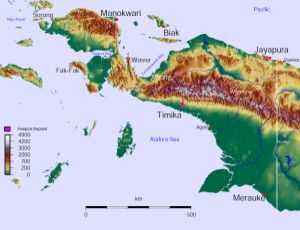
The province has 40 major rivers, 12 lakes, and 40 islands. The Mamberamo river is the province's largest and runs through the north of the province. The result is a large area of lakes and rivers known as the Lakes Plains region. The southern lowlands, habitats of which included mangrove, tidal and freshwater swamp forest and lowland rainforest, are home to populations of fishermen and gatherers such as the Asmat people. The Baliem Valley, home of the Dani people, is a tableland 1,600 m (5,250 ft) above sea level in the midst of the central mountain range.
The dry season across the region is generally between May and October; although drier in these months, rain persists throughout the year. Strong winds and rain are experienced along the north coast in November through to March. However, the south coast experiences an increase in wind and rain between April and October, which is the dry season in the Merauke area, the only part of West Papua to experience distinct seasons. Coastal areas are generally hot and humid, whereas the highland areas tend to be cooler.
Ecology
Lying in the Asia-Australian transition zone near Wallacea, the region's flora and fauna include Asiatic, Australian, and endemic species. The region is 75% forest and it has a high degree of biodiversity. The island has an estimated 16,000 species of plant, 124 genera of which are endemic. The mountainous areas and the north are covered with dense rainforest. Highland vegetation also includes alpine grasslands, heath, pine forests, bush and scrub. The vegetation of the south coast includes mangroves and sago palms, and in the drier southeastern section, eucalypts, paperbarks, and acacias.
Marsupial species dominate the region; there are an estimated 70 marsupial species (including possums, wallabies, tree-kangaroos, cuscus), and 180 other mammal species (including the endangered long-beaked echidna). The region is the only part of Indonesia to have kangaroos, marsupial mice, bandicoots, and ring-tailed possums. The approximately 700 bird species include cassowaries (along the southern coastal areas), bowerbirds, kingfishers, crowned pigeons, parrots, and cockatoos). Approximately 450 of these spieces are endemic. Birds of paradise can be found in Kepala Burung and Yapen. The region is also home to around 800 species of spiders, 200 frogs, 30,000 beetles, 70 bat species, the world's longest lizards (Papua monitor) and some of the world's largest butterflies. The waterways and wetlands of Papua are habitat for salt and freshwater crocodiles, tree monitors, flying foxes, ospreys, and other animals; while the equatorial glacier fields remain largely unexplored.
In February 2005, a team of scientists exploring the Foja Mountains discovered numerous new species of birds, butterflies, amphibians, and plants, including a species of rhododendron which may have the largest bloom of the genus.[11]
Environmental issues include deforestation, the spread of the introduced Crab-eating Macaque which now threatens the existence of native species, and discarded copper and gold tailings from the Grasberg mine.[12]
Flora and fauna on the Bird's Head Peninsula
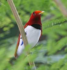
The Bird's Head Peninsula, also known as the Doberai Peninsula, is covered by the Vogelkop Montane Rain Forests Ecoregion. It includes more than 22,000 km² of montane forests at elevations of 1,000 m and higher.[13] Over 50% of these forests are located within protected areas. There are over 300 bird species on the peninsula, of which at least 20 are unique to the ecoregion, and some live only in very restricted areas. These include the grey-banded munia, Vogelkop bowerbird, and the king bird-of-paradise.[14]
Road construction, illegal logging, commercial agricultural expansion and ranching potentially threaten the integrity of the ecoregion.[14] The south-eastern coast of the Bird's Head Peninsula forms part of the Teluk Cenderawasih National Park.[15]
Demographics
| Historical population | ||
|---|---|---|
| Year | Pop. | ±% |
| 1971 | 923,440 | — |
| 1980 | 1,173,875 | +27.1% |
| 1990 | 1,648,708 | +40.5% |
| 1995 | 1,942,627 | +17.8% |
| 2000 | 2,220,934 | +14.3% |
| 2010 | 3,593,803 | +61.8% |
The population of the region was estimated to be 3,593,803 in 2010.[16] The interior is predominantly populated by ethnic Papuans and coastal towns are inhabited by descendants of intermarriages between Papuans, Melanesians and Austronesians, including the Indonesian ethnic groups. Migrants from the rest of Indonesia also tend to inhabit the coastal regions. The two largest cities in the territory are Manokwari in the northeast of the Bird's Head Peninsula and Jayapura in the northeast. Both cities have a population of approximately 200,000.

The region is home to around 312 different tribes, including some uncontacted peoples.[17] The Dani, from the Baliem Valley, are one of the most populous tribes of the region. The Manikom and Hatam inhabit the Anggi Lakes area, and the Kanum and Marind are from near Merauke. The semi-nomadic Asmat inhabit the mangrove and tidal river areas near Agats and are renowned for their woodcarving. Other tribes include the Amungme, Bauzi, Biak (Byak), Korowai, Lani, Mee, Mek, Sawi, and Yali. Estimates of the number of distinct languages spoken in the region range from 200 to 700. A number of these languages are permanently disappearing.
As in Papua New Guinea and some surrounding east Indonesian provinces, a large majority of the population is Christian. In the 2000 census 54% identified themselves as Protestant, 24% as Catholic, 21% as Muslim, and less than 1% as either Hindu or Buddhist. There is also substantial practice of animism among the major religions, but this is not recorded by the census.
Haplogroups
There are 6 main Y-chromosome haplogroups in West Papua; Y-chromosome haplogroup M is the most common, with Y-chromosome haplogroup O2a as a small minority in second place and Y-chromosome haplogroup S back in third position across the mountain highlands; while D, C2 and C4 are of negligible numbers.
- Haplogroup M is the most frequently occurring Y-chromosome haplogroup in West Papua.[18]
- In a 2005 study of Papua New Guinea's ASPM gene variants, Mekel-Bobrov et al. found that the Papuan people have among the highest rate of the newly evolved ASPM haplogroup D, at 59.4% occurrence of the approximately 6,000-year-old allele.[19]
- Haplogroup O2a (M95) is typical of Austroasiatic peoples, Tai–Kadai peoples, Malays, Indonesians, and Malagasy, with a moderate distribution throughout South, Southeast, East, and Central Asia.
- Haplogroup S occurs in eastern Indonesia (10–20%) and Island Melanesia (~10%), but reaches greatest frequency in the highlands of Papua New Guinea (52%).[20]
Extinction
In 2012, the Tampoto tribe in Skow Mabo village, Jayapura, was on the brink of extinction, with only a single person (a man in his twenties) still living; the Dasem tribe in Waena area, Jayapura, also is near extinction, with only one family consisting of several people still alive. A decade ago, the Sebo tribe in the Kayu Pulau region, Jayapura Bay, died out. Hundreds of Papuan tribes have their own individual languages; they are unable to compete in the acculturation process with other groups, and some tribes have resisted acculturation.
Culture
West Papuans have significant cultural affinities with the inhabitants of Papua New Guinea. As in Papua New Guinea the peoples of the highlands have distinct traditions and languages from peoples of the coast, though Papuan scholars and activists have recently detailed cultural links between coast and highlands as evidenced by close similarity of family names. In some parts of the highlands, the koteka (penis gourd) is worn by males in ceremonies. The use of the koteka as everyday dress by Dani males in Western New Guinea is still common.
History
Papuan habitation of the region is estimated to have begun between 42,000 and 48,000 years ago.[1] Research indicates that the highlands were an early and independent center of agriculture, and show that agriculture developed gradually over several thousands of years and that banana has been cultivated in this region since at least 7,000 years ago.[21]
Austronesian peoples migrating through Maritime Southeast Asia settled in the area at least 3,000 years ago, and populated especially in Cenderawasih Bay. Diverse cultures and languages have developed in situ; there are over 300 languages and two hundred additional dialects in the region (See Papuan languages, Austronesian languages, Central–Eastern Malayo-Polynesian languages).
European discovery
In 1526–27, the Portuguese explorer Jorge de Menezes accidentally came upon the principal island in the Biak archipelago and is credited with naming it Papua, from a Malay word pepuah, for the frizzled quality of Melanesian hair.[22] Heading east, he eventually reported the northern coast of the Bird's Head Peninsula and the Waigeo Island, and named the region Ilhas dos Papuas (Islands of Papuans).[23]
In 1545 the Spaniard Yñigo Ortiz de Retez sailed along the north coast as far as the Mamberamo River near which he landed, naming the island Nueva Guinea. In 1606 Spanish navigator Luís Vaz de Torres[24] sailed along the southwestern part of the island in present-day Papua, and also claimed the territory for the King of Spain.
Near the end of the sixteenth century, Sultanate of Ternate under Sultan Baabullah (1570–1583), had influence over parts of Papua.[25]
Netherlands New Guinea


In 1660, the Dutch recognised the Sultan of Tidore's sovereignty over New Guinea. New Guinea thus became notionally Dutch as the Dutch held power over Tidore. In 1793, Britain established a settlement near Manokwari. However, it failed. By 1824 Britain and the Netherlands agreed that the western half of the island would become part of the Dutch East Indies. In 1828 the Dutch established a settlement in Lobo (near Kaimana) which also failed. Great Britain and Germany had recognised the Dutch claims on western New Guinea in treaties of 1885 and 1895. Dutch activity in the region remained minimal in the first half of the twentieth century. Dutch, US, and Japanese mining companies explored the area's rich oil reserves in the 1930s. In 1942, the northern coast of West New Guinea and the nearby islands were occupied by Japan.[26] In 1944, Allied forces gained control of the region through four-phase campaign from neighbouring Papua New Guinea. The United States constructed a headquarters for MacArthur at Hollandia (Jayapura) intended as a staging point for operations taking of the Philippines. Papuan men and resources were used to support the Allied war effort in the Pacific. After the war's end the Dutch regained possession of the region.
Since the early twentieth century, Indonesian nationalists had sought an independent Indonesia based on all Dutch colonial possessions in the Indies, including western New Guinea. In December 1949, the Netherlands recognised Indonesian sovereignty over the Dutch East Indies with the exception of Dutch New Guinea, the issue of which was to be discussed within a year. In attempt to prevent Indonesia taking control of the region and to prepare the region for self-rule, the Dutch significantly raised development spending off its low base,[27] began investing in Papuan education, and encouraged Papuan nationalism. A small western elite developed with a growing political awareness attuned to the idea of independence, with close links to neighbouring eastern New Guinea which was administered by Australia.[28] A national parliament was elected in 1961.
Integration into Indonesia
Sukarno made the takeover of western New Guinea a focus of his continuing struggle against Dutch imperialism and part of a broader Third World conflict with the West.[29] Although Indonesian seaborne and paratroop incursions into the territory met with little success,[30] the Dutch knew that a military campaign to retain the region would require protracted jungle warfare, and, unwilling to see a repeat of their futile efforts in the armed struggle for Indonesian independence in the 1940s, agreed to American mediation. The negotiations resulted in the UN-ratified New York Agreement of September 1962,[31] which required authority to be transferred to a United Nations Temporary Executive Authority (UNTEA) and then to Indonesia, from 1 May 1963, until such time as a plebiscite could be organized to allow Papuans to determine whether they wanted independence or union with Indonesia. Accordingly, in 1969, the United Nations supervised the "Act of Free Choice", in which the Indonesian government used a musyawarah (a traditional consensus of elders) to decide the region's status. The 1,054 elders voted for union with Indonesia.[32] The 1969 Act of Free Choice is considered contentious, with even United Nations observers recognizing the elders were placed under duress and forced to vote yes.[33] Soon after, the region became the 26th province of Indonesia, with full international and United Nations recognition.
The separatist Free Papua Movement (OPM) has engaged in a small-scale yet bloody conflict with the Indonesian military since the 1960s. Rebellions occurred in remote mountainous areas in 1969, 1977, and the mid-1980s, occasionally spilling over into Papua New Guinea. In 1996, 5,000 Papuans rioted and burned the Abepura market in Jayapura, resulting in several deaths. The same year, OPM members kidnapped European and Indonesian researchers in a remote part of the Baliem Valley. The Europeans were released four months later; however, two Indonesian hostages were killed.[34] In the Post-Suharto era, the national government began a process of decentralisation of the provinces, including, in December 2001, "Special Autonomy" status for Papua province and a reinvestment into the region of 80% of the taxation receipts generated by the region. In 2003, the province of "West Papua" was created in the Bird's Head Peninsula and surrounding islands to its west.
Administration
The West Papua region is currently administered as two Indonesian provinces:
- The province of Papua contains 28 regencies (kabupaten) and one city (kota) at the 2010 Census, which were subdivided into 385 districts (kecamatan), and thence into "villages" (kelurahan and desa). The 28 existing regencies are: Asmat; Biak-Numfor; Boven Digoel; Central Mamberamo; Deiyai; Dogiyai; Intan Jaya; Jayapura; Jayawijaya; Keerom; Lanny Jaya; Mamberamo Raya; Mappi; Merauke; Mimika; Nabire; Nduga; Paniai; Pegunungan Bintang; Puncak; Puncak Jaya; Sarmi; Supiori; Tolikara; Waropen; Yahukimo; Yalimo; and Yapen Islands. The city of Jayapura, which also has the status equivalent to a regency, is the largest city in the West Papua region.
- The province of West Papua contains twelve regencies (kabupaten) and one city (kota) at the 2010 Census, which were subdivided into 154 districts (kecamatan). The existing regencies in West Papua are: Arfak Mountains; Fakfak; Kaimana; Manokwari; Maybrat; Raja Ampat; Sorong; South Manokwari; South Sorong; Tambrauw; Teluk Bintuni; and Teluk Wondama. The city of Sorong, which also has the status equivalent to a regency, is the largest city in the West Papua province, but the current capital city is Manokwari.
- Reports suggest that the formation of three new provinces have recently been approved by Indonesia's House of Representatives: South Papua, Central Papua and Southwest Papua.[35] 25 new regencies and 3 new municipalities are also to be created.
From Papua province, the 17 new regencies to be created are those of Gili Menawa, Moyo, Balin Senter, Bogogha, Puncak Trikora, Muara Digul, Admi Korbay, Katengban, Okika, Northwest Yapen, East Yapen, Numfor Island, Yalimek, Mambera Hulu, Southwest Yahukimo, East Yahukimo and Gondumisisare, while the 2 new municipalities are Merauke City and Baliem Valley.
In West Papua, the 8 new regencies to be created are those of Malamoy, Maibratsau, North Raja Ampat, South Raja Ampat, Raja Maskona, Okas, West Manokwari and Imeo, while the new municipality is Manokwari City.
References
- ↑ 1.0 1.1 Gillespie, Richard (2002). "Dating the First Australians" (PDF). Radiocarbon 44 (2): 455–72. Retrieved 24 May 2010. Archived 19 August 2014
- ↑ U.S. Dept. of Defence; International Crisis Group; and International Crisis Group. Archived 19 August 2014.
- ↑ Leith, Denise (2003). The Politics of Power: Freeport in Suharto's Indonesia. University of Hawaii Press. p. xxv.
- ↑ "Cursed by plenty: Paying a covert visit to Papua's fighters in the forest". The Economist. 8 July 2010. Retrieved 1 April 2011.
- ↑ Cribb, R.B.; Kahin, Audrey (2004). Historical Dictionary of Indonesia. Scarecrow Press. p. 313.
- ↑ Rees, Stuart (2003). Passion for Peace: Exercising Power Creatively. UNSW Press. p. 150.
- ↑ Ver Berkmoes, Ryan (2010). Indonesia. Lonely Planet. p. 775.
- ↑ Frank Jacobs (March 13, 2012). "Who Bit My Border?". The New York Times.
- ↑ (Whitten (1992), p. 182
- ↑ List at GunungBagging.com Retrieved 26 January 2012.
- ↑ Robin McDowell: 'Lost world' yields exotic new species – The Vancouver Sun – 8 February 2006
- ↑ Grasberg MineSite | InfoMine
- ↑ Flip van Helden: A bird's eye view of the Bird's Head Peninsula, in Irian Jaya Studies Programme for Interdisciplinary Research (IIAS) Newsletter nr.37, June 2005, retrieved 11 May 2010
- ↑ 14.0 14.1 WWF: Bird wonders of New Guinea's western-most province, retrieved 11 May 2010
- ↑ Ministry of Forestry: Teluk Cenderawasih NP, retrieved 11 May 2010
- ↑ "Hasil Final Jumlah Penduduk Indonesia 2010". Indonesiadata.co.id. 2011-06-09. Retrieved 2012-11-07.
- ↑ Survival International – Papua
- ↑ Kayser M, Brauer S, Weiss G, Schiefenho¨vel W, Underhill P, Shen P, Oefner P, Tommaseo-Ponzetta M, Stoneking (2003) Reduced Y-Chromosome, but Not Mitochondrial DNA, Diversity in Human Populations from West New Guinea Am J Hum Genet 72:281–302
- ↑ "Ongoing Adaptive Evolution of ASPM, a Brain Size Determinant in Homo sapiens", Science, 9 September 2005: Vol. 309. no. 5741, pp. 1720–1722.
- ↑ Murray P. Cox and Marta Mirazón Lahr, "Y-Chromosome Diversity Is Inversely Associated With Language Affiliation in Paired Austronesian- and Papuan-Speaking Communities from Solomon Islands," American Journal of Human Biology 18:35–50 (2006)
- ↑ T. P. Denham et al 2003, Origins of Agriculture at Kuk Swamp in the Highlands of New Guinea. Science 11 July 2003: Vol. 301 no. 5630 pp. 189–193 doi:10.1126/science.1085255
- ↑ The World Almanac and Book of Facts 1985
- ↑ J.H.F. SOLLEWUN GELPKE, On the Origin of the Name Papua
- ↑ Translation of Torres's report to the king in Collingridge, G. (1895) Discovery of Australia pp. 229–237. Golden Press Edition, 1983, Gradesville, NSW. ISBN 0-85558-956-6
- ↑ Witton, Patrick (2003). Indonesia (7th edition). Melbourne: Lonely Planet. p. 821. ISBN 1-74059-154-2.
- ↑ Klemen, L. "The Fall of Dutch New Guinea, April 1942". Forgotten Campaign: The Dutch East Indies Campaign 1941–1942.
- ↑ McDonald (1980), p. 65
- ↑ McDonald (1980), p. 64.
- ↑ Vickers (2005), p. 139
- ↑ McDonald, Hamish (28 January 2008). "No End to Ambition". Sydney Morning Herald.
- ↑ McDonald, Hamish (1980). Suharto's Indonesia. Blackburn, Victoria: Fontana Books. p. 36. ISBN 0-00-635721-0.
- ↑ Friend (2003), p. 72 (expand reference)
- ↑ Singh, Bilveer Papua: Geopolitics and the Quest for Nationhood, Transaction Publishing, 2008 p. 86
- ↑ Friend (2003), pp. 272–273 (expand reference above)
- ↑ http://www.thejakartaglobe.com/news/new-provinces-receive-the-nod/
- Bibliography
- Leith, Denise. 2002. The Politics of Power: Freeport in Suharto's Indonesia. Honolulu: University of Hawaii Press. ISBN 0-8248-2566-7
- Conboy, Ken. 2003. Kopassus. Equinox Publishing, Jakarta Indonesia. ISBN 979-95898-8-6
- Penders, C.L.M., The West New Guinea debacle. Dutch decolonisation and Indonesia 1945–1962, Leiden 2002, KITLV
- "Arrow Against the Wind." Narrative of documentary on people of Asmat and Dani, their culture, and their relationship with the nature http://www.dgmoen.net/video_trans/004.html
- Throwim Way Leg by Tim Flannery
- Neles Tebay : West Papua. The struggle for peace with justice. Catholic Institute for International Relations: London 2005, ISBN 1 85287 316 7.
- Marshall, A.J. and B. Beehler (eds.), "The Ecology of Papua". 2007. Parts 1 & 2 as Vol. 6 in "The Ecology of Indonesia" series. Singapore: Periplus Press.
External links
Coordinates: 4°00′S 136°00′E / 4.000°S 136.000°E
| ||||||||||||||||||||||||||||||
| ||||||||||||||||||||||||||||||||||||||||||