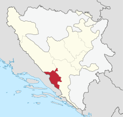
West Herzegovina Canton
| West Herzegovina Canton Županija Zapadnohercegovačka
|
||||||
|---|---|---|---|---|---|---|
|
||||||
 |
||||||
| Status | Canton of the Federation of Bosnia and Herzegovina | |||||
| Capital and largest city | Široki Brijeg | |||||
| Official languages | Croatian and Bosnian | |||||
| Ethnic groups (1991) | Croats 96.82% Muslims 1.81% others 1.37% |
|||||
| Demonym | West Herzegovinian | |||||
| Government | Parliamentary system | |||||
| - | Prime Minister | Zdenko Ćosić | ||||
| Legislature | Assembly of West Herzegovina Canton | |||||
| Canton of the Federation of Bosnia and Herzegovina | ||||||
| - | Establishment | 12 June 1996 | ||||
| Area | ||||||
| - | Total | 1,362 km2 525.8 sq mi |
||||
| Population | ||||||
| - | 2013 census | 97,893 | ||||
| - | Density | 71.87/km2 186.18/sq mi |
||||
| GDP (nominal) | 2013 estimate | |||||
| - | Total | BAM 487.211 million | ||||
| - | Per capita | BAM 4976.97 | ||||
| Currency | BAM | |||||
| Time zone | CET (UTC+1) | |||||

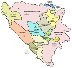
The West Herzegovina Canton, officially the County of West Herzegovina[1] (Croatian: Županija Zapadnohercegovačka)[1] is one of the cantons of the Federation of Bosnia and Herzegovina. The West Herzegovina Canton is in the Herzegovina region in the southwest of Bosnia and Herzegovina. Its seat of government is in Široki Brijeg, while other municipalities within the Canton are Grude, Ljubuški and Posušje. The West Herzegovina Canton is one of the most developed and richest cantons. It has 81,414 inhabitants, of whom an absolute majority are Croats.
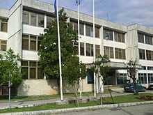
Administration
The Government of the West Herzegovina Canton is located in Široki Brijeg and has seven ministries:[2]
- Ministry of Internal Affairs
- Ministry of Justice and Administration
- Ministry of Finance
- Ministry of Planning, Construction and Environment
- Ministry of Education, Science, Culture and Sports
- Ministry of Healthcare, Work and Welfare
- Ministry of Veterans
Economy
This region, as well as the entire West Herzegovina, was before the war one of the poorest regions in BiH. Today it is one of the richest.[3] The entrepreneurial spirit is also present in the West Herzegovina Canton, which has enabled high employment. The majority of entrepreneurs are in the catering industry, but a significant number of entrepreneurs are involved in a successful production.[4]
Despite the canton's small area, its agricultural sector is important. In the canton, 30,000 ha (120 sq miles) is used for agriculture; 84,000 ha (320 sq miles) is forest. Around 6,000 ha of arable land is below 100 metres in altitude. The Canton has a strong potential for the production of vegetables, fruit and wine. The Canton has meat and milk processing plants.[4]
Geography and population
Geography
West Herzegovina Canton is located in the Herzegovina region of south west Bosnia and Herzegovina. It has Čvrsnica mountain to the north, Croatia to the west and south, and the Herzegovina-Neretva Canton to the east. The area of the Canton is 1,363 km²[5] (526 sq miles).
The canton has three rivers: Lištica, Trebižat and Ričina, and the Blidinje Lake. Its highest peak is Pločno on the Čvrsnica mountain, 2,228 metres.[5]
Population
The West Herzegovina Canton has 81,414 inhabitants, according to 2011 data. The vast majority of the population (98%) are Croats.[5] The largest municipality is Široki Brijeg with 26,304 inhabitants, followed by Ljubuški with 23,634, Posušje with 15,994 and Grude with 15,428.
According to the 1999 estimate, Široki Brijeg had 29,530 inhabitants, of whom[6] there were:
- Croats, 29,439 (99.69%)
- Serbs, 80 (0.27%)
- Bosniaks, 11 (0.04%)
On the 1991 census, the municipality of Ljubuški had 28,340 inhabitants:
- Croats, 26,127 (92.19%)
- Bosniaks, 1,592 (5.61%)
- Yugoslavs, 227 (0.80%)
- Serbs, 65 (0.22)
- others, 92 (0.35%)
According to the 1991 census, the municipality of Posušje had 17,134 inhabitants:
- Croats 16,963 (99.00%)
- Yugoslavs, 26 (0.15%)
- Serbs, 9 (0.05%)
- Bosniaks, 6 (0.03%)
- others, 130 (0.76%)
According to the 1991 census, the municipality of Grude had 16,358 inhabitants:
- Croats, 16,210 (99.09%)
- Serbs, 9 (0.05%)
- Yugoslavs, 5 (0.03%)
- Bosniaks, 4 (0.02%)
- others, 130 (0.79%)
Official holidays
According to local laws[7] the official holidays (non-working days) in the county are :
- January 1-New Year
- January 6- Epiphany
- May 1 - Labour Day
- May 30- Pan-Croatian statehood day
- August 15 - Assumption of Mary
- November 1- All Saints' Day
- November 2- All Souls' Day
- November 18- the foundation of Herzeg Bosnia
- December 25 and 26 - Christmas Day and St. Stephen's Day
See also
External links
References
- ↑ 1.0 1.1 Ministry of Economy of the County of West Herzegovina From the Constitution of county: The official name of the county is County of West Herzegovina
- ↑ "Ministarstva" (in Croatian). Government of the West Herzegovina Canton. Retrieved 18 August 2012.
- ↑ Bakula: Nemamo izbora - smanjit ćemo plaće
- ↑ 4.0 4.1 "Poljoprivreda". Government of the West Herzegovina Canton. Retrieved 28 August 2012.
- ↑ 5.0 5.1 5.2 "Općenito o Županiji" (in Croatian). Government of the West Herzegovina Canton. Retrieved 16 August 2012.
- ↑ "Demografska slika" (in Croatian). Official site of Široki Brijeg. 31 May 2007. Retrieved 16 August 2012.
- ↑ http://uip-zzh.com/uip-zzh.com/files/zakoni/rad/9-04.pdf
| ||||||||||||