Weißeritz
| (United) Weißeritz (Vereinigte) Weißeritz | |
|---|---|
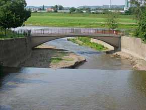 The Weißeritz estuary in Dresden. | |
| Origin | confluence of the Wild Weißeritz and Red Weißeritz |
| Mouth |
Elbe 51°3′48″N 13°41′12″E / 51.06333°N 13.68667°ECoordinates: 51°3′48″N 13°41′12″E / 51.06333°N 13.68667°E |
| Basin countries | Germany |
| Length | 12 km (61 km incl. Wild Weißeritz) |
| Source elevation | 188 m |
The Weißeritz is a river in Saxony. The 12 km short left tributary of the Elbe runs through Freital and Dresden. Its name is derived from west Slavic bystrica (wild water). The official name of the river used in documents and hydrographic maps is Vereinigte Weißeritz (United Weißeritz). The highest points of the Weißeritz watershed are at about 800 metres elevation.
The river is formed by the confluence of the Wild Weißeritz and Red Weißeritz in Freital. Nevertheless the Wild Weißeritz is the longest tributary, the watersheds of both Weißeritz rivers are almost equal in area (162.7 km² and 161.2 km²).
The Weißeritz crosses the deep valley Plauenscher Grund between Freital and Dresden and enters the Dresden Basin. The railway line from Dresden to Nuremberg runs next to the river in his close valley. The river is displaced in an old sidearm in Dresden for flood protection reasons and therefore canalised.
The Weißeritz caused heavy damages during the 2002 European floods in Dresden and Freital. The river reached Dresden Central Station as well as the Zwinger and flooded some districts of the inner city. Due to the river's high fall from 188 m to 106 m in Dresden some houses were completely destroyed in the torrential flood. The river left its canalised bed near the inner city and went through its old run directly towards the Elbe river.