Wayville, South Australia
| Wayville Adelaide, South Australia | |||||||||||||
|---|---|---|---|---|---|---|---|---|---|---|---|---|---|
|
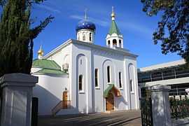
St. Nicholas Russian Orthodox Church on Greenhill Road | |||||||||||||
| Population |
1,734 (2006 Census)[1] 1,642 (2001 Census)[2] | ||||||||||||
| Established | 1899 | ||||||||||||
| Postcode(s) | 5034 | ||||||||||||
| Time zone | ACST (UTC+9:30) | ||||||||||||
| • Summer (DST) | ACDT (UTC+10:30) | ||||||||||||
| LGA(s) | City of Unley[3] | ||||||||||||
| State electorate(s) | South Australia | ||||||||||||
| Federal Division(s) | Australia | ||||||||||||
| |||||||||||||
| |||||||||||||
Wayville is an inner-southern suburb of Adelaide in the City of Unley. It is most notable for its hosting of the Royal Adelaide Show at the Royal Adelaide Showgrounds. The suburb is bordered to the north with the South Park Lands of Adelaide, and mostly to the south with the tramline. The particular bordering locations of the South Park Lands are as follows:KURRANGGA, WALYO YERTA, MINNO WIRRA, and WIKAPARNDO WIRRA. The southern border consists of a number of landmarks. Starting at the Leader St. train crossing, the boundary follows Leader Sr. until Goodwood Rd. The bounday then follows Parsons St. and crosses the tram line. Finally the southern boundary follows Simpson Pde. The east boundary is King William Road and the western boundary is the train tracks. Keswick creek flows through the southern side of the suburb.
History
In the 1860s where Wayville is now, this region was originally a milk run rented from the South Australian Company. The extension of King William Road to Greenhill Road was done in the 1870s, and this is the north-east boundary. Wayville was first subdivided in 1881, but it was named Goodwood at that time. In 1899 the area was named Wayville after James Way.
Wayville Post Office opened around 1909. Wayville Military Post Office was open from 16 July 1940 until 19 October 1946 while the Showgrounds were used as an army camp.[4]
Points of interest
The Latvian Hall or TALAVA, meaning the old mountain castle, was established in 1966. The hall is located 4 Clark Street, Wayville, Adelaide SA 5034. The hall is rented out to community, and supported by the Latvian Chamber of Commerce and Industry in Australia Inc. (LCCIA).
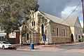
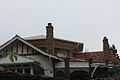
The Church of Emmanuel is part of the Anglican Church of Australia. The Church of Emmanuel is located on the corner of Young St and Clark St, Wayville and forms part of the Anglican Parish of Parkside, along with the St. Oswald's Church in Parkside. The corner stone was laid by His Excellency the Governor Sir C. T. M. Bridges, K.C.M.G, C.B., D.S.O. on the 28th of April, 1923. This church is due to be closed in 2014.
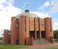
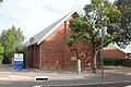
The St. Michael the Archangel Church is part of the Roman Catholic (Latin Rite) Society of St. Pius X.[5] The church was first built in 1894, the cornerstone laid on September 15, 1894. The church and hall was rebuilt in 1948. The new cornerstone was laid by Mrs. T. Playford (wife of the Premier [Thomas Playford IV]) on November 20, 1948.
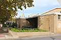
There is a Ukrainian Catholic Church,[6] Protection of Mother of God Parish, on Davenport Tce. On the church grounds is a memorial, "In memory of soldiers who died for liberation of Ukraine". Next this memorial is a smaller one, "In memory of Michael Sukmanowsky Ukrainian boy scout killed in Vietnam". The St. Peters Latvian EV-Lutheran Memorial Church was erected in the memory of those who served in World One (1914–1918) and World War Two (1939–1945). The church is part of the Evangelical Lutheran Church of Latvia of Adelaide. The church was built in 1971.
-
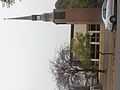
St. Peter's Church
-
The Ukrainian Catholic Church
-
The St. Michael Church
-
The Emmanuel Church
-
The Latvian Hall of South Australia
The Adelaide Showground Farmers Market is open every Sunday: 9am - 1pm. The purpose of the market is to sell food and food related products by farmers and producers of South Australia. Entrance to the market is from the Leader St. (South) side of the Adelaide Showground.
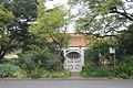
The house Amphi Cosma [7][8] was built in 1914 by the noted Adelaide master builder Walter C. Torode for his own use. The architecture is of particular interest because of its octagonal unique design and its reinforced concrete structure, a noteworthy feature being a central reinforced concrete pillar and a series of radiating beams.
-
Amphi Cosma front
-
Amphi Cosma roof
-

Amphi Cosma side
Education
Annesley Junior School is an independent day school for girls and boys aged from two years old to year 6, located on Greenhill Rd. This is on the northern edge of the suburb. The school was established in 1902 originally as Methodist Ladies' College (MLC).
The Alliance Française d’Adelaide[9] on 319 Young St. is an Australian not-for-profit association set up to promotion French language and culture. The Alliance Française d’Adelaide offers a range of French language courses. They sponsor a number of French culture events for music and the Alliance Française French Film Festival.
Fusion Business College [10] is a provider of training and development solutions to retail businesses. Fusion Business College is accredited by the Australian Government as a Registered Training Organisation. Fusion Business Solutions was founded by Marc Brien and his wife Karen in July 1999.
Central Queensland University Appleton Institute is a multidisciplinary research hub located in Adelaide. The institute was founded in 2012. It is located at 44 Greenhill Road, Wayville. It has a teaching program in Safety Science.
The SACE Board of South Australia [11] an independent statutory authority established under the SACE Board of South Australia Act 1983, with responsibility for the accreditation, assessment, recognition and certification of learning in the South Australian Certificate of Education (the SACE). SACE Board of South Australia is located at 60 Greenhill Rd, Wayville, SA 5034 (Phone: 08 8372 7400).
Transportation
There are two Glenelg Tram stops[12] in Wayville. These are Greenhill Rd - Tram Stop 1 and Wayville - Tram Stop 2. Just outside of Wayville in Goodwood there is a third tram stop, Goodwood Rd - Tram Stop 3. There are three bus stops on Goodwood Road, stops 1, 2, and 3. On Greenhill Road there are five stops, 1B, 1C, 2, 2A, and 2B. Finally on King William Road there are two stops, 1 and 2. On the northern side of the suburb is Greenhill Road is part of A21 the City Ring Route, Adelaide.
Popular bike trails for Wayville may be found at BikeMap.
Mike Turtur Bikeway[13] [14] is from the City of Adelaide to Glenelg. Part of the bikeway runs along the edge of Wayville. The Mike Turtur Bikeway is the busiest cycling commuter route connected to the city.
Accommodation
Rosemary's Place is designed to be country friendly accommodation. The accommodation consists of two fully furnished comfortable and inexpensive 1 bedroom maisonettes in the heart of Wayville. It provides easy access to medical, government, and education services. It is located at 7 Rose Terrace.
Rectory Cottage is a B&B located at 15 Rose Terrace, Wayville, SA. The cottage was built in 1900 as a pastor’s residence. The cottage is two bedrooms and is self-contained.
Rose Terrace Lodge is located at 102 Rose Terrace. This is a Supported Residential Facilities.
Notable people
- Vickie Chapman, Australian politician lived in Wayville
- Sara Douglass, Australian fantasy writer went to school in Wayville
- Oswald Bertram Lower, Australian chemist and pharmacist known for his contributions to entomology lived in Wayville
- Sally Newmarch, Australian triple Olympic rower went to school in Wayville
- Scott McPhee, Australian cyclist lives in Wayville
- Joseph Albert Riley, prominent South Australian businessman lived in Wayville
- Arthur Baker-Clack, Australian-born painter went to school in Wayville
- Alison Mary Dolling, (pen-name Mary Broughton) Australian writer went to school in Wayville
- Walter C. Torode noted Adelaide master builder lived in Wayville
References
- ↑ Australian Bureau of Statistics (25 October 2007). "Wayville (State Suburb)". 2006 Census QuickStats. Retrieved 19 July 2008.
- ↑ Australian Bureau of Statistics (9 March 2006). "Wayville (State Suburb)". 2001 Census QuickStats. Retrieved 17 July 2010.
- ↑ When and Where In Unley: A Chronology 1906 - 2006. Retrieved May 11, 2013.
- ↑ Premier Postal History. "Post Office List". Premier Postal Auctions. Retrieved 26 May 2011.
- ↑ Society of St. Pius X. Retrieved May 25, 2013
- ↑ Ukrainian Catholic Church Retrieved June 1, 2013
- ↑ Dwelling (former 'Amphi Cosma') built and designed by WC Torode Retrieved June 30, 2013
- ↑ Architectural works in South Australia Torode Retrieved June 30, 2013
- ↑ Alliance Française d’Adelaide Retrieved June 10, 2013
- ↑ Fusion Business College Retrieved June 10, 2013
- ↑ The SACE Board of South Australia Jan 19, 2014
- ↑ Adelaide Metro Tram Timetables. Retrieved May 25, 2013
- ↑ Mike Turtur Bikeway. Retrieved Jan. 19, 2014
- ↑ Mike Turtur route map Retrieved Jan. 19, 2014
| ||||||