Wayne Township, Warren County, Ohio
| Wayne Township, Warren County, Ohio | |
|---|---|
| Township | |
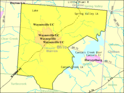 Detailed map of Wayne Township | |
| Coordinates: 39°31′46″N 84°4′55″W / 39.52944°N 84.08194°WCoordinates: 39°31′46″N 84°4′55″W / 39.52944°N 84.08194°W | |
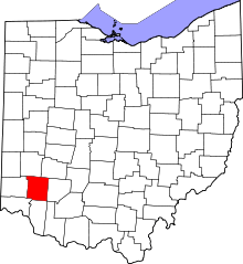
| Country | United States |
| State | Ohio |
| County | Warren |
| Area | |
| • Total | 46.3 sq mi (120.0 km2) |
| • Land | 44.8 sq mi (116.1 km2) |
| • Water | 1.5 sq mi (3.9 km2) |
| Elevation[1] | 722 ft (220 m) |
| Population (2000) | |
| • Total | 7,250 |
| • Density | 161.7/sq mi (62.4/km2) |
| Time zone | Eastern (EST) (UTC-5) |
| • Summer (DST) | EDT (UTC-4) |
| FIPS code | 39-82306[2] |
| GNIS feature ID | 1087123[1] |
Wayne Township is one of the eleven townships of Warren County, Ohio, United States. It is located in the northeast part of the county and includes the village of Waynesville, Ohio. Its population in 2000 was 7,250, up from 5,744 in 1990; 4,436 of this total lived in the unincorporated portions of the township.[3] Waynesville is noted for its antique stores and is the home of a sauerkraut festival. Caesar Creek State Park is located here.
Geography
Located in the northeastern corner of the county, it borders the following townships:
- Sugarcreek Township, Greene County - north
- Spring Valley Township, Greene County - northeast
- Chester Township, Clinton County - east
- Massie Township - southeast
- Washington Township - south
- Turtlecreek Township - southwest
- Clearcreek Township - west
- Washington Township, Montgomery County - northwest
The village of Corwin is in the township, as are the communities of Mount Holly and Crosswick. The Little Miami River, which forms a portion of the township's boundary, flows through the middle of the township. The Little Miami Bike Trail, along the route of the former Little Miami Railroad, also passes through the township.
The portion of Wayne Township east of the Little Miami is in the Virginia Military District and was surveyed with the metes and bounds system, while the area west of the Little Miami was surveyed on the same plan as used in the Symmes Purchase.
Named for General "Mad" Anthony Wayne, it is one of twenty Wayne Townships in Ohio.
History
One of the original townships of Warren County, it was created on May 10, 1803, nine days after the county was erected. The original boundaries were: "Beginning at the northeast corner of Section 33 in the third township; thence east to the northeast corner of the county; thence south to a point drawn due east from the north boundard of the third military range; thence due west to the southwest corner of Section 25, in the fourth range; thence due north to the place of beginning." When created, Warren County extended much farther to the east than today and Wayne Township encompassed a large area now in Clinton County. On June 26, 1806, Eaton Township was created from that part of Wayne lying east of Caesars Creek. On August 4, 1804, a strip two miles wide was taken from the south side and made part of the new Turtlecreek Township and on September 11, 1815, a two-mile wide strip was cut of the west side and added to the new Clearcreek Township. On October 10, 1850, Massie Township was created from parts of Wayne and Washington Townships.
Government
The township is governed by a three-member board of trustees, who are elected in November of odd-numbered years to a four-year term beginning on the following January 1. Two are elected in the year after the presidential election and one is elected in the year before it. There is also an elected township fiscal officer,[4] who serves a four-year term beginning on April 1 of the year after the election, which is held in November of the year before the presidential election. Vacancies in the fiscal officership or on the board of trustees are filled by the remaining trustees.
Public services
Most of the township is in the Wayne Local School District, but parts are in the Lebanon, Spring Valley, Clinton Massie and Xenia districts.
The township is mainly in the Waynesville telephone exchange, but parts are in the Spring Valley, Bellbrook, Lebanon, and Centerville exchanges.
References
- Elva R. Adams. Warren County Revisited. [Lebanon, Ohio]: Warren County Historical Society, 1989.
- Robert L. Black. The Little Miami Railroad. Cincinnati: n.p., 1940.
- The Centennial Atlas of Warren County, Ohio. Lebanon, Ohio: The Centennial Atlas Association, 1903.
- Josiah Morrow. The History of Warren County, Ohio. Chicago: W.H. Beers, 1883. (Reprinted several times)
- Ohio Atlas & Gazetteer. 6th ed. Yarmouth, Maine: DeLorme, 2001. ISBN 0-89933-281-1
- William E. Smith. History of Southwestern Ohio: The Miami Valleys. New York: Lewis Historical Publishing, 1964. 3 vols.
- Warren County Engineer's Office. Official Highway Map 2003. Lebanon, Ohio: The Office, 2003.
- ↑ 1.0 1.1 "US Board on Geographic Names". United States Geological Survey. 2007-10-25. Retrieved 2008-01-31.
- ↑ "American FactFinder". United States Census Bureau. Retrieved 2008-01-31.
- ↑ Warren County, Ohio — Population by Places Estimates Ohio State University, 2007. Accessed 15 May 2007.
- ↑ §503.24, §505.01, and §507.01 of the Ohio Revised Code. Accessed 4/30/2009.
External links
| |||||||||||||||||||||||||||||||||