Waterways, Oxford
| Waterways | |
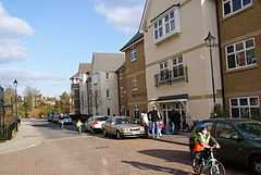 Community litter-picking at Waterways. |
|
 Waterways |
|
| OS grid reference | SP502084 |
|---|---|
| Civil parish | unparished |
| District | Oxford |
| Shire county | Oxfordshire |
| Region | South East |
| Country | England |
| Sovereign state | United Kingdom |
| Post town | Oxford |
| Postcode district | OX2 |
| Dialling code | 01865 |
| Police | Thames Valley |
| Fire | Oxfordshire |
| Ambulance | South Central |
| EU Parliament | South East England |
| UK Parliament | Oxford West and Abingdon |
| Website | Waterways World |
|
|
Coordinates: 51°46′19″N 1°16′23″W / 51.772°N 1.273°W
The Waterways is housing estate in North Oxford, England. It is west of the Oxford Canal and east of the Cherwell Valley railway line.[1][2] To the west beyond the railway line are Port Meadow and the River Thames. The estate begins in the south as a continuation of Frenchay Road, part of Victorian North Oxford, and as Elizabeth Jennings Way connects with the Woodstock Road (A4144) at the northern end of the estate.
The estate was built between 2000 and 2006, on the site of the British Motor Corporation's former Osberton Radiator Factory. There is a Waterways Residents Association (WRA).[3]
References
- ↑ "About the Waterways". Oxford, UK: The Waterways. Retrieved 6 September 2012.
- ↑ The Waterways estate, Oxford, Wikimapia.
- ↑ "Waterways Residents Association (WRA)". Oxford, UK: The Waterways. Retrieved 6 September 2012.
| ||||||||||||||||||||||||||||||