Waterford Parish, New Brunswick
| Waterford | |
|---|---|
| Parish | |
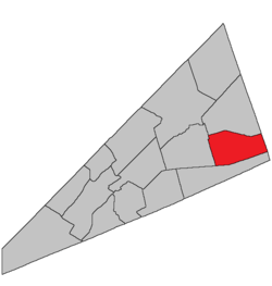 Location within Kings County, New Brunswick. | |
| Coordinates: 45°50′N 64°35′W / 45.84°N 64.59°W | |
| Country |
|
| Province |
|
| County | Kings County |
| Established | 1786 |
| Area[1] | |
| • Land | 221.12 km2 (85.37 sq mi) |
| Population (2011)[1] | |
| • Total | 458 |
| • Density | 2.1/km2 (5/sq mi) |
| • Pop 2006-2011 |
|
| • Dwellings | 235 |
| Time zone | AST (UTC-4) |
| • Summer (DST) | ADT (UTC-3) |
Waterford is a Canadian parish in Kings Parish, New Brunswick.[2] Poley Mountain is located here.
History
Waterford Parish created from Sussex Parish in 1874: named for County Waterford, Ireland.
Delineation
Waterford Parish is defined in the Territorial Division Act as:
Communities
Parish population total does not include incorporated municipalities (in bold):
|
|
Bodies of water & Islands
This is a list of rivers, lakes, streams, creeks, marshes and Islands that are at least partially in this parish
Demographics
PopulationPopulation trend[3]
|
LanguageMother tongue language (2006)[4]
|
Access Routes
Highways and numbered routes that run through the parish, including external routes that start or finish at the parish limits:[5]
|
|
|
See also
References
- ↑ 1.0 1.1 2011 Statistics Canada Census Profile: Waterford Parish, New Brunswick
- ↑ New Brunswick Provincial Archives - Waterford Parish
- ↑ Statistics Canada: 2001, 2006 census
- ↑ Profile: Waterford Parish, New Brunswick
- ↑ Atlantic Canada Back Road Atlas ISBN 978-1-55368-618-7
 |
Cardwell Parish | | ||
| Sussex Parish | |
Elgin Parish | ||
| ||||
| | ||||
| Hammond Parish | Alma Parish |
| ||||||||||||||||||
Coordinates: 45°41′20″N 65°22′21″W / 45.688854°N 65.372515°W