Washington Street Elevated
The Washington Street Elevated was an elevated segment of Boston's Massachusetts Bay Transportation Authority subway system, comprising the southern stretch of the Orange Line (named after the original name for a section of Washington St, Orange St.). It ran from Chinatown through the South End and Roxbury, ending in Forest Hills in Jamaica Plain.
History
Construction
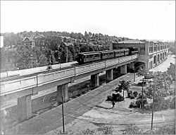
The initial section of the Main Line Elevated opened on June 10, 1901, running from Sullivan Square in Charlestown over the Charlestown Elevated, through the Canal Street Incline into the Tremont Street Subway, and out the Pleasant Street Portal onto the Washington Street Elevated. The initial section of the elevated ran only to Dudley Square, with intermediate stations at Dover and Northampton.[1] The Atlantic Avenue Elevated opened on August 22 of that year, joining the Washington Street El at Tower D Junction.[1]
The El, Boston's first heavy rail metro line, proved extremely popular. The Washington Street Tunnel was opened on November 30, 1908, providing a separate route for the Main Line and allowing use of the Tremont Street Subway for through streetcars. The southern portal of the tunnel connected with the Elevated at Tower D.[1] The Elevated was extended south to Forest Hills on November 22, 1909, with an intermediate station at Egleston to transfer passengers from streetcars serving Roxbury and Dorchester.[1] Although the Elevated was built primarily to replace radial streetcar lines running to downtown, ridership from the areas surrounding the stations proved high, and an infill station at Green Street with fewer streetcar connections was opened on September 22, 1912.[1]
Replacement
The Washington Street Elevated was the last elevated section of the Orange Line to remain standing. The Atlantic Avenue Elevated ended service in 1938, while the Charlestown Elevated was replaced with the largely surface-level Haymarket North Extension in 1975.[1]
By the 1980s, however, the Elevated was showing its age. The steel uprights had lost a substantial portion of their mass to rusting, though it was not structurally unsound since it was heavily overbuilt. However, the stations were less solidly constructed, and with their narrow steel stairways and wooden platforms they would have required substantial renovations for continued usage and handicapped accessibility. Additionally, the Elevated was unpopular with many residents since it was noisy and deprived much of Washington Street of sunlight.
From 1979 to 1987, the four-track railroad embankment between Back Bay and Forest Hills, originally acquired for a cancelled highway project, was converted to a trench with three mainline tracks and two rapid transit tracks as the Southwest Corridor project. Addition of rapid transit to the corridor had been proposed as a branch of the Green Line in 1926, and as a relocation of the Orange Line since 1966.[2] The last service over the Washington Street Elevated ran on April 30, 1987; service began over the Southwest Corridor route on May 4.[1]
Silver Line
Since the Southwest Corridor was located somewhat to the west away from neighborhood centers like Dudley and Egleston Squares, the MBTA promised that a light rail branch of the Green Line would be built to provide continued rapid transit service to those areas. However, such service was not forthcoming; instead the #49 Northampton - Washington & Kneeland feeder bus route was extended to Dudley and given a more direct routing.[1]
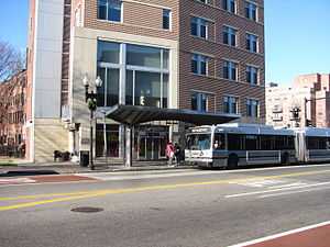
In 2002, the MBTA deployed bus rapid transit along much of the route from Dudley Square to Downtown Crossing in the form of Phase I of the controversial Silver Line, replacing the local 49 bus.[1] Although branded as bus rapid transit, the Washington Street section of the Silver Line is considered BRT creep as it lacks bus rapid transit elements like dedicated bus lanes and pre-pay stations.[3] The Silver Line has been subject to neighborhood criticism for reducing the number of available bus stops along the route while not sufficiently reducing travel time compared to the previous conventional bus service.
The 2003 Program for Mass Transportation included the possibility of converting the Washington Street section of the Silver Line to light rail (as had originally been promised) using the abandoned southern section of the subway to connect to the Central Subway at Boylston. However, the Phase III tunnel and continued bus service was recommended instead.[4] In 2012, the Roxbury-Dorcester-Mattapan Transit Needs Study recommended the conversion to light rail and reuse of the tunnel as a long-term project, with the additional possibility of extending the line down Blue Hill Avenue to Mattapan along the #28 route.[5]
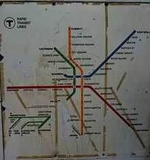
Stations

The Washington Street Elevated consisted of six stations, the most complex and major of which were at Dudley Square and Forest Hills. Most of the original stations were designed by architect Alexander Wadsworth Longfellow, Jr. and originally featured much in the way of ornamentation and architectural prowess. By the time the "El" closed, however, much of this detail had been lost to decades of decay, neglect and cost-cutting.
Forest Hills Station was designed by Edmund March Wheelwright and was quite different from the other stations along the line, featuring a square stone exterior rather than sloping rooflines. The majority of stations were scrapped; however, Northampton Station was sold to the Seashore Trolley Museum (Kennebunkport, Maine) and still exists there. Parts of Dudley Station were saved and incorporated into the current bus station.[6]
The stations themselves were:
| Station | Location | Opened[1] | Transfers and notes | |
|---|---|---|---|---|
| Forest Hills | Arborway and Washington St, Jamaica Plain | November 22, 1909 | Green Line "E" Branch (suspended from 1985), Forest Hills Cemetery | |
| Green | Green and Washington Sts, Jamaica Plain | September 11, 1912 | ||
| Egleston | Egleston Square, Roxbury/Jamaica Plain | November 22, 1909 | ||
| Dudley | Dudley Square, Roxbury | June 10, 1901 | ||
| Northampton | Northampton St, South End | June 10, 1901 | ||
| Dover | Dover St (now East Berkeley St), South End | June 10, 1901 | ||
| Tower D junction, to Atlantic Avenue Elevated (1901-1938), Washington Street Tunnel (1908-1987), and Tremont Street Subway (1901-1908) | ||||
References
- ↑ 1.0 1.1 1.2 1.3 1.4 1.5 1.6 1.7 1.8 1.9 Belcher, Jonathan (23 March 2013). "Changes to Transit Service in the MBTA district" (PDF). NETransit. Retrieved 12 August 2013.
- ↑ Central Transportation Planning Staff (15 November 1993). "The Transportation Plan for the Boston Region - Volume 2". National Transportation Library. Retrieved 12 August 2013.
- ↑ Weinstock, Annie et al. (May 2011). "Recapturing Global Leadership in Bus Rapid Transit: A Survey of Select U.S. Cities" (PDF). Institute for Transportation & Development Policy. Retrieved 12 August 2013.
The majority of the system lacks basic BRT features.
- ↑ "Chapter 5C: System Expansion" (PDF). Program of Mass Transportation. Boston Regional Metropolitan Planning Organization. May 2003 [revised January 2004]. p. 5C-76. Archived from the original (PDF) on 6 February 2012. Retrieved 6 May 2013. Check date values in:
|date=(help) - ↑ "Roxbury-Dorchester-Mattapan Transit Needs Study" (PDF). Massachusetts Department of Transportation. September 2012. Retrieved 7 May 2013.
- ↑ Hopkinson, Peter; Parkinson, Kenneth (August 1995). "Intermodalism brings new life to old rail stations". The American City & Country 110 (9): 20. Retrieved 23 October 2014 – via Proquest Historical Newspapers. (subscription required (help)).
External links
| Wikimedia Commons has media related to Washington Street Elevated. |
- Photos of the old Main Line Elevated
- Text on and illustrations of old Main Line Elevated
- Historic American Engineering Record entry
- YouTube link of Outbound Orange Line train on the Washington Street Elevated
- theelevated.org
- Conservation of Matter: The Fall and Rise of Boston’s Elevated Subway - documentary showing demolition of Washington Street Elevated and recycling into a bridge in Arizona
| ||||||||||||||||||||||||||||||||||||||||||||||||||||||||||