Wasenhorn
| Wasenhorn | |
|---|---|
| Punta Terrarossa | |
|
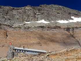
The south side of the Wasenhorn from the Monte Leone Hut | |
| Elevation | 3,246 m (10,650 ft) |
| Prominence | 476 m (1,562 ft)[1] |
| Parent peak | Monte Leone |
| Location | |
 Wasenhorn Location in the Alps | |
| Location |
Piedmont, Italy Valais, Switzerland |
| Range | Lepontine Alps |
| Coordinates | 46°16′00″N 8°05′09″E / 46.26667°N 8.08583°ECoordinates: 46°16′00″N 8°05′09″E / 46.26667°N 8.08583°E |
The Wasenhorn (in German, in Italian: Punta Terrarossa; 3,246 m) is a mountain of the Lepontine Alps, located on the border between Switzerland and Italy. It lies halfway between Brig (Swiss canton of Valais) and Varzo (Italian region of Piedmont), just north of Monte Leone, in the Simplon Pass area. Politically the Wasenhorn is split between the municipalities of Ried-Brig and Varzo.
The normal route to the summit of the Wasenhorn starts from the Monte Leone Hut of the Swiss Alpine Club (2,848 m), located on the south side of the mountain, above the Chaltwasser Pass, which connects the Simplon Pass with the Alpe Veglia.
The Simplon Tunnel runs into the massif of the Wasenhorn, below the subsidiary summit named Tunnelspitz (2,903 m).
References
External links
![]() Media related to Wasenhorn at Wikimedia Commons
Media related to Wasenhorn at Wikimedia Commons