Warwick, Queensland
| Warwick Queensland | |||||||
|---|---|---|---|---|---|---|---|
|
Town Hall | |||||||
 Warwick | |||||||
| Coordinates | 28°13′0″S 152°01′0″E / 28.21667°S 152.01667°ECoordinates: 28°13′0″S 152°01′0″E / 28.21667°S 152.01667°E | ||||||
| Population | 13,376 (2011)[1] | ||||||
| Established | 1850 | ||||||
| Postcode(s) | 4370 | ||||||
| Elevation | 477 m (1,565 ft) | ||||||
| Location |
| ||||||
| LGA(s) | Southern Downs Region | ||||||
| State electorate(s) | Southern Downs | ||||||
| Federal Division(s) | Maranoa | ||||||
| |||||||
.jpg)
Warwick /ˈwɒrɪk/[2] is a town in southeast Queensland, Australia, lying 130 kilometres (81 mi) south-west of Brisbane. It is the administrative centre of the Southern Downs local government area. At the 2011 Australian Census the town recorded a population of 13,376.[1]
The surrounding Darling Downs have fostered a strong agricultural industry for which Warwick, together with the larger city of Toowoomba, serve as convenient service centres. Warwick is situated on the Condamine River. The Cunningham Highway and the New England Highway pass through the town.
History
The Warwick Green Belt, on the banks of the Condamine River features a sculpture of Tiddalik the mythical frog that drank all of the fresh water in a renowned Aboriginal Dreamtime story.[3]
Patrick Leslie and his two brothers originally settled in the area as squatters, naming their run Canning Downs. In 1847 the NSW government asked Leslie to select a site on his station for a township, which was to be called 'Cannington,' although the name 'Warwick' was eventually settled on. Land sales were held in 1850, and the first allotment was bought by Leslie.[4] The telegraph to Brisbane was operating by 1861. The 1870s were boom years for this new town. In 1871 the railway reached Warwick,[5] a brewery was built in 1873, then a cooperative flour mill and brickworks were completed during 1874.
Warwick was the seat of a series of local government areas, the Borough of Warwick from 1861, Town of Warwick from 1903, City of Warwick from 1936, Shire of Warwick from 1994, and Southern Downs Region from 2008.
An event officially known as the Warwick Incident[6] occurred on 29 November 1917, which would lead to the formation of the Australian Commonwealth Police with the first commissioner for Commonwealth Police appointed eight days later. As Prime Minister William Morris Hughes was addressing a crowd at the Warwick railway station, a man in the crowd threw an egg dislodging the Prime Minister's hat. Hughes ordered his arrest but the Queensland State Police allegedly refused to carry out the order.
Monuments
A statue of the 12th Queensland Premier Thomas Joseph Byrnes is located on the corner of Palmerin and Grafton Streets.[7]
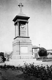

The war memorial in Warwick was built in 1923 and the memorial gates were built in 1924.[8]
Climate
| Climate data for Warwick, Queensland | |||||||||||||
|---|---|---|---|---|---|---|---|---|---|---|---|---|---|
| Month | Jan | Feb | Mar | Apr | May | Jun | Jul | Aug | Sep | Oct | Nov | Dec | Year |
| Record high °C (°F) | 40.9 (105.6) |
38.5 (101.3) |
37.2 (99) |
33.3 (91.9) |
29.7 (85.5) |
26.3 (79.3) |
26.0 (78.8) |
33.0 (91.4) |
35.1 (95.2) |
37.1 (98.8) |
38.0 (100.4) |
40.4 (104.7) |
40.9 (105.6) |
| Average high °C (°F) | 30.1 (86.2) |
29.3 (84.7) |
27.5 (81.5) |
24.9 (76.8) |
21.0 (69.8) |
18.3 (64.9) |
17.9 (64.2) |
20.0 (68) |
23.6 (74.5) |
25.8 (78.4) |
27.6 (81.7) |
29.1 (84.4) |
24.6 (76.3) |
| Average low °C (°F) | 17.0 (62.6) |
17.0 (62.6) |
14.9 (58.8) |
11.3 (52.3) |
6.7 (44.1) |
4.8 (40.6) |
3.1 (37.6) |
3.1 (37.6) |
7.1 (44.8) |
10.4 (50.7) |
13.7 (56.7) |
15.8 (60.4) |
10.4 (50.7) |
| Record low °C (°F) | 9.6 (49.3) |
7.9 (46.2) |
2.9 (37.2) |
−1.8 (28.8) |
−4.7 (23.5) |
−7.0 (19.4) |
−7.7 (18.1) |
−6.3 (20.7) |
−3.8 (25.2) |
0.9 (33.6) |
1.9 (35.4) |
6.5 (43.7) |
−7.7 (18.1) |
| Average precipitation mm (inches) | 82.7 (3.256) |
64.7 (2.547) |
62.6 (2.465) |
31.5 (1.24) |
40.5 (1.594) |
36.8 (1.449) |
27.2 (1.071) |
23.2 (0.913) |
36.0 (1.417) |
73.9 (2.909) |
90.2 (3.551) |
101.9 (4.012) |
670.4 (26.394) |
| Avg. precipitation days | 8.8 | 8.8 | 8.6 | 7.3 | 7.9 | 9.2 | 7.7 | 5.7 | 6.6 | 8.3 | 10.0 | 10.5 | 99.5 |
| Average relative humidity (%) | 47 | 50 | 47 | 46 | 47 | 50 | 44 | 38 | 36 | 38 | 44 | 43 | 44.2 |
| Mean monthly sunshine hours | 241.8 | 193.2 | 220.1 | 234 | 217 | 183 | 223.2 | 241.8 | 252 | 235.6 | 225 | 241.8 | 2,708.5 |
| Source: Bureau of Meteorology[9] | |||||||||||||
Newspapers
Newspapers in Warwick include the Warwick Daily News, the Warwick and Southern Downs Weekly and the Southern Free Times.
Former newspapers include:
- Warwick Argus published from 1879 to 1919
- Warwick Argus and Tenterfield Chronicle
- Warwick Examiner and Times
Notable people
Notable people with a connection to Warwick include:
- Francis Andersen, Australian scholar in the fields of biblical studies and Hebrew, born in Warwick
- Wayne Bennett, rugby league player and coach, raised in and played football in Warwick
- Anna Bligh, former Premier of Queensland, born in Warwick
- Lee Bodimeade, hockey player, born in Warwick
- Dean Butler, hockey player, born in Warwick
- Thomas Joseph Byrnes, former Premier of Queensland, Member of the Legislative Assembly for Warwick
- Charles Chauvel, filmmaker, born in Warwick
- Patrick Leslie, pioneer settler in Warwick
- Alan Marshall, cricket player, born in Warwick
- Mervyn Meggitt, anthropologist, born in Warwick
- Matthew Norman, attended school in Warwick
- Arthur Morgan, former Premier of Queensland, born in Warwick and Member of the Legislative Assembly for Warwick
- Paul Neville, politician, born in Warwick
- Adrienne Pickering, actress, born in Warwick
- Chris Pickering, musician, born and raised in Warwick
- Russell Skerman, Supreme Court Judge, attended Warwick High School
- Duncan Thompson, Australian rugby league footballer, coach and administrator, born in Warwick
- William Webb, judge, attended school in Warwick
Events
- FEI Eventing World Cup (May)
- Jumpers and Jazz in July Festival (July)
- The "Rose Bowl" Polocrosse Carnival (August)
- Warwick Rodeo (October)
- Rose Festival (October)
- Warwick Cricket Association Australia Day Cricket Carnival (January)
See also
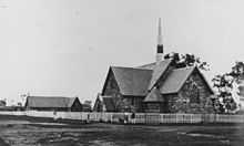
- First St. Mary's Roman Catholic Church, Warwick
References
- ↑ 1.0 1.1 Australian Bureau of Statistics (31 October 2012). "Warwick (Urban Centre)". 2011 Census QuickStats. Retrieved 8 August 2013.
- ↑ Macquarie Dictionary, Fourth Edition (2005). Melbourne, The Macquarie Library Pty Ltd. ISBN 1-876429-14-3
- ↑ "Other Attractions". Southern Downs Regional Council.
- ↑ "Warwick Historical Information". www.smh.com.au. 15 August 2007. Retrieved 2006-12-14.
- ↑ The Centenary of the Southern Line Kerr, J.D. Australian Railway Historical Society Bulletin, December, 1970 pp261-291
- ↑ Warwick Incident, published 7 January 2007 (accessed 7 January 2007)
- ↑ Gibson, Lisanne; Joanna Besley (2004). Monumental Queensland: Signposts on a Cultural Landscape. University of Queensland Press. p. 26. ISBN 0702234656. Retrieved 8 August 2013.
- ↑ "Warwick War Memorial". Queensland War Memorial Register. Retrieved 3 April 2014.
- ↑ "Climate Statistics for Warwick, Queensland". Retrieved April 14, 2014.
Further reading
- Heritage Trails of Great South East by the Queensland Environmental Protection Agency
- Local Government Reform Commission, http://www.dlgp.qld.gov.au/resources/map/reform/southern-downs-rationale.pdf (8/3/2010)
External links
| Wikimedia Commons has media related to Warwick, Queensland. |
| ||||||||||||||||||||||