Warstein
| Warstein | ||
|---|---|---|
|
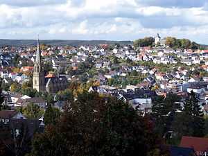
View of Warstein with St. Pancratius and the Old Church | ||
| ||
 Warstein | ||
Location of Warstein within Soest district 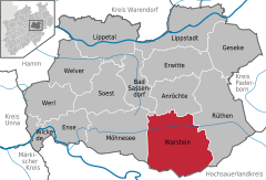
 | ||
| Coordinates: 51°27′N 8°21′E / 51.450°N 8.350°ECoordinates: 51°27′N 8°21′E / 51.450°N 8.350°E | ||
| Country | Germany | |
| State | North Rhine-Westphalia | |
| Admin. region | Arnsberg | |
| District | Soest | |
| Government | ||
| • Mayor | Manfred Gödde (BG) | |
| Area | ||
| • Total | 157.91 km2 (60.97 sq mi) | |
| Population (2013-12-31)[1] | ||
| • Total | 25,247 | |
| • Density | 160/km2 (410/sq mi) | |
| Time zone | CET/CEST (UTC+1/+2) | |
| Postal codes | 59581 | |
| Dialling codes |
02902 (Warstein), 02925 (Allagen) | |
| Vehicle registration | SO | |
| Website | www.warstein.de | |

Warstein ([ˈvaːɐ̯ˌʃtaɪn]) is a town in the district of Soest, in North Rhine-Westphalia, Germany. It is located at the north end of the Sauerland.
Geography
Warstein is located north of the Arnsberger Wald (forest) at a brook called Wäster. The area south of the city is mostly forested; the lightly forested Haarstrang mountain is to the north. The river Möhne flows between these two areas. The highest elevation is 581 m (1,906 ft) in the south of the city near a hill called Stimm Stamm; the lowest elevation is 216 m (709 ft) in the village Waldhausen in the north.
Neighbouring municipalities
The following towns border Warstein (clockwise, beginning in the north): Anröchte, Rüthen, Bestwig, Meschede, Arnsberg, Möhnesee, Bad Sassendorf.
Division of the town
Warstein consists of the following 9 districts:
|
|
History
Evidence of human life was found in the Bilsteinhöhle cave between Warstein and Hirschberg. Warstein was first mentioned officially in 1072. Historians once thought Warstein was organized as an official town in 1276, but that is wrong. Probably it became a town in the same year as Belecke in 1296. In the Middle Ages Warstein was part of the Hanseatic League, that is a trade association for guilds, a very important international business association at that time. A fire in 1802 destroyed big parts of the town. After that the town centre was moved to the Wester brook. In 1844 the Amt Warstein was founded. It was part of the Archbishopric Cologne till 1902. In 1975 Warstein and the other eight independent villages became the new town of Warstein.
The decrease of population in Warstein since 1998:
- 1998: 29.102
- 1999: 29.084
- 2000: 29.028
- 2001: 29.007
- 2002: 29.012
- 2003: 28.762
- 2004: 28.629
List of mayors
- Manfred Gödde (BG) - since 2004
- Georg Juraschka (SPD) - 1999 to 2004
- Manfred Gödde - before 1999
International relations
Warstein is twinned with:
-
 Saint-Pol-sur-Ternoise (France) -- since 1964
 -
 Wurzen (Saxony, Germany) -- since 3 October 1990
 -
 Hebden Royd (United Kingdom) -- since November 1995
 -
 Pietrapaola (Italy) -- an official friendship since 2001
Economy
The largest employer in Warstein is the Warsteiner Brauerei founded in 1753. It is one of the largest breweries in Germany and is famous all over the world.
Literature
- Heppekausen, Wolfgang; Clewing, Christian: Warstein: Bilder einer sauerländischen Stadt. Selbstverlag, Warstein 2001. ISBN 3-00-008520-3
- Gerte, Franz im Auftrag der Volkshochschule Möhne-Lippe: Wie war das?: Belecke 1923-1948. Selbstverlag, Belecke 2001.
- Bamberg, Fritz: Die neue Stadt Warstein in alten Ansichten. Europäische Bibliothek, Zaltbommel 1986. ISBN 90-288-3363-3
- Bender, Josef: Geschichte der Stadt Warstein. Stein, Werl 1973. ISBN 3-920980-03-4
- Sandgathe, Günther: Die Stadt Warstein im Dreissigjährigen Krieg. Selbstverlag, Warstein 1971.
References
- ↑ "Amtliche Bevölkerungszahlen". Landesbetrieb Information und Technik NRW (in German). 4 September 2014.
External links
- Official site (German)
- Warsteiner brewery homepage (German)
| Wikimedia Commons has media related to Warstein. |
| ||||||||