Warren, Oregon
| Warren, Oregon | |
|---|---|
| Census-designated place | |
|
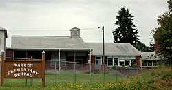
Warren Elementary School | |
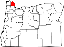
 Warren Location within the state of Oregon | |
| Coordinates: 45°49′9″N 122°50′52″W / 45.81917°N 122.84778°WCoordinates: 45°49′9″N 122°50′52″W / 45.81917°N 122.84778°W | |
| Country | United States |
| State | Oregon |
| County | Columbia |
| Area | |
| • Total | 6.3 sq mi (16.4 km2) |
| • Land | 6.3 sq mi (16.3 km2) |
| • Water | 0.04 sq mi (0.1 km2) |
| Population (2010) | |
| • Total | 1,787 |
| • Density | 284/sq mi (109.6/km2) |
| Time zone | Pacific (PST) (UTC-8) |
| • Summer (DST) | PDT (UTC-7) |
| ZIP codes | 97053 |
| FIPS code | 41-78800 |
Warren is an unincorporated community and census-designated place in Columbia County, Oregon, United States, located on U.S. Route 30 north of Scappoose and south of St. Helens on Scappoose Bay of the Columbia River. As of the 2010 census it had a population of 1,787.[1]
The Warren post office was established in 1885; it was named by local resident James Gill for his hometown of Warren, Massachusetts.[2] The post office was discontinued in 1888, but reestablished in 1890 as "Gilltown" because there was another post office named Warren in Umatilla County.[2] The Columbia County office became Warren again in 1895, and the Umatilla County office was closed in 1902; the locality in Umatilla County is now known as Myrick.[2]
Climate
This region experiences warm (but not hot) and dry summers, with no average monthly temperatures above 71.6 °F. According to the Köppen Climate Classification system, Warren has a warm-summer Mediterranean climate, abbreviated "Csb" on climate maps.[3]
References
- ↑ "Geographic Identifiers: 2010 Demographic Profile Data (G001): Warren CDP, Oregon". U.S. Census Bureau, American Factfinder. Retrieved April 16, 2013.
- ↑ 2.0 2.1 2.2 McArthur, Lewis A.; Lewis L. McArthur (2003) [1928]. Oregon Geographic Names (Seventh Edition ed.). Portland, Oregon: Oregon Historical Society Press. pp. 1011–1012. ISBN 0-87595-277-1.
- ↑ Climate Summary for Warren, Oregon
| |||||||||||||||||||||