Ware Lock
| Ware Lock | |
|---|---|
|
Ware Lock | |
| Waterway | River Lee Navigation |
| County | Hertfordshire |
| Maintained by | Environment Agency |
| Operation | Manual |
| First built | 1855 |
| Length | 85 feet (25.9 m) |
| Width | 16 feet (4.9 m) |
| Fall | 7 feet 6 inches (2.3 m) |
| Distance to Bow Creek | 25 miles (40 km) |
| Distance to Hertford Castle Weir | 1.3 miles (2.1 km) |
| Geographic data | |
| Coordinates | 51°48′39″N 0°02′28″W / 51.810842°N 0.041049°WCoordinates: 51°48′39″N 0°02′28″W / 51.810842°N 0.041049°W |
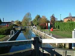
Ware Lock (No2) is a lock on the River Lee Navigation at Ware. The lock stands adjacent to Ware Weir and is the only lock on the Navigation to be operated and maintained by the Environment Agency. [1]
Public access
The lock stands on the River Lee Navigation towpath which forms part of the Lea Valley Walk.
Public transport
External links
References
| Next lock upstream | River Lee Navigation | Next lock downstream |
| Hertford Lock 0.5 mile |
Ware Lock Grid reference: TL3502914331 |
Hardmead Lock 2.5 miles |
| ||||||||||||||||||||||||||