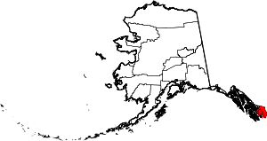
Ward Cove, Alaska
| Ward Cove | |
|---|---|
| Unincorporated community | |
 Ward Cove Location within the state of Alaska | |
| Coordinates: 55°24′43″N 131°43′22″W / 55.41194°N 131.72278°WCoordinates: 55°24′43″N 131°43′22″W / 55.41194°N 131.72278°W | |
| Country | United States |
| State | Alaska |
| Borough | Ketchikan Gateway |
| Government | |
| • Borough mayor | Dave Kiffer[1] |
| Elevation | 164 ft (50 m) |
| Time zone | Alaska (AKST) (UTC-9) |
| • Summer (DST) | AKDT (UTC-8) |
| ZIP codes | 99928 |
| GNIS feature ID | 1415612[2] |
Ward Cove (also Wacker, Wacker City, or Wards Cove) is an unincorporated community in Ketchikan Gateway Borough, Alaska, United States. Its elevation is 164 feet (50 m).[2] Although it is unincorporated, it has a post office, with the ZIP code of 99928.[3]
This village is an extension of the settlement area of Ketchikan northwest along the highway. A saltery was established in Ward Cove in 1883-84 by W. W. Waud. Eugene Wacker was first postmaster of the Wacker post office, which was established 1920. The post office name was changed to Wards Cove in 1951 and then to Ward Cove in 1954. The village population was 57 at the 1930 census. The name "Ward Cove" was declared official in 1966 by the Board on Geographic Names.[2]
The settlement lies on the northern shore of Ward Cove, at the southwestern end of Revillagigedo Island, 4½ mi (7¼ km) northwest of Ketchikan, Alex. Arch.[2]
References
- ↑ "2013 ACoM Members". Online Resource Center, Alaska Conference of Mayors. Juneau: Alaska Municipal League. 2013. Retrieved May 29, 2013.
- ↑ 2.0 2.1 2.2 2.3 "Ward Cove, Alaska". Geographic Names Information System. United States Geological Survey. Retrieved 2008-02-27.
- ↑ Zip Code Lookup
| |||||||||||||||||||||||||||||
