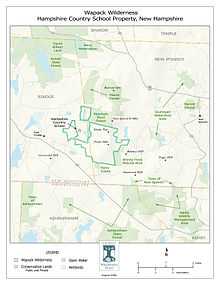
Wapack Wilderness


The Wapack Wilderness is a 1,400-acre (6 km2) tract of forest in the towns of Rindge and New Ipswich, New Hampshire. The land is owned by the Hampshire Country School, a small, private school for students who do not thrive in traditional settings. It abuts Binney Pond Natural Area and land conserved by the New England Forestry Foundation.[1] Watatic Mountain Wildlife Area[2] is two miles (3 km) to the southeast, and Annett State Forest[3] is two miles (3 km) to the northeast. The headwaters of the Millers River flow from the area, feeding into Converse Meadows and Lake Monomonac before entering Massachusetts.[4]
The wilderness contains more than a mile of the historic Wapack Trail and features wetlands, rare natural communities, rocky ridges, and old-growth forest. The area is rich with wildlife, including moose, bobcat, fisher, mink, weasel, beaver, otter, white-tailed deer, coyote, red fox, ducks, warblers, and salamanders.
Notes
- ↑ New England Forestry Foundation. Retrieved on 2009-01-20.
- ↑ "Resource Management Plan: Mount Watatic Reservation". Massachusetts Department of Conservation and Recreation (DCR). Retrieved 2009-01-20.
- ↑ "Annett Wayside Park". New Hampshire Division of Parks and Recreation. Retrieved 2009-01-20.
- ↑ Poor, Eric. "Easement would protect 1,400 acres: Rindge, New Ipswich conservation commissions each plan $50K donation to $1.4 million effort." Monadnock Ledger-Transcript, 30 January 2007: 3.
External links
- Hampshire Country School
- Friends of the Wapack
- New Ipswich Conservation Commission
- Northeast Wilderness Trust
Coordinates: 42°44′N 71°56′W / 42.733°N 71.933°W