Wanhatti
| Wanhatti | |
|---|---|
| Resort | |
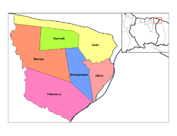 Map showing the resorts of Marowijne District. | |
 Wanhatti Map showing the resorts of Marowijne District. | |
| Coordinates: 5°48′N 54°27′W / 5.800°N 54.450°W | |
| Country |
|
| District | Marowijne District |
| Area | |
| • Total | 461 km2 (178 sq mi) |
| Elevation | 0 m (0 ft) |
| Population (2012) | |
| • Total | 466 |
| • Density | 1.0/km2 (2.6/sq mi) |
| Time zone | AST (UTC-3) |
Wanhatti is a town and resort in Suriname, located in the Marowijne district on the Cottica River.
Coordinates: 5°48′N 54°27′W / 5.800°N 54.450°W
| ||||||||||||||||||||||||||||||||||||||||||||