Wanfang Community Station
Wanfang Community Station 萬芳社區站 | |
 | |
|---|---|
| Wanfang Community Station | |
| Location | |
| Municipality | Taipei |
| District(s) | Wenshan |
| Address | No. 60, Wanfang Rd. |
| Info | |
| Type | Elevated |
| History | |
| Opened | March 28, 1996 |
| Rail services | |
| Line(s) | Wenshan Line (BR11) |
| Daily Ridership | 3,791 (2011)[1] (Ranked 87th of 89) |
| Operator(s) | Taipei Rapid Transit System |
| Wanfang Community Station | |||||||||
| Traditional Chinese | 萬芳社區站 | ||||||||
|---|---|---|---|---|---|---|---|---|---|
| Simplified Chinese | 万芳社区站 | ||||||||
| |||||||||
Wanfang Community Station is a station on the Wenshan Line of the Taipei Metro, located in Wenshan District, Taipei, Taiwan.[2]
Station overview
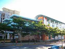
The station is elevated, has two side platforms, and has a single exit. It is located on the south side of Wanfang Rd., close to its intersection with Wanhe Rd.
Station layout
| 2F | |
| Platform 1 | ← Wenshan Line toward Taipei Nangang Exhibition Center (Wanfang Hospital) |
| Platform 2 | → Wenshan Line toward Taipei Zoo (Muzha) → |
| 1F | |
| Concourse | Exit/Entrance, lobby, information desk, automatic ticket dispensing machines, one-way faregates, restrooms |
Exits
- Single Exit: Wanfang Rd.

Around the station
- Wanfang Community
- Wanfang Elementary School
- Yuanye Sports Park
| Preceding station | Taipei Metro | Following station | ||
|---|---|---|---|---|
toward Taipei Nangang Exhibition Center | Brown Line Wenshan Line | toward Taipei Zoo |
References
| Wikimedia Commons has media related to Wanfang Community Station. |
- ↑ "Passenger Volume at Taipei Rapid Transit Stations" (PDF). Taipei City Department of Transportation. 2012-01-20. Retrieved 2012-02-05.
- ↑ "Route Map: Wanfang Community". Taipei Rapid Transit Corporation. Retrieved 2010-06-10.
Coordinates: 24°59′55″N 121°34′05″E / 24.998639°N 121.56801°E