Wanakuni (Peru)
This article is about the mountain in the Cusco Region, Peru. For the mountain in the Cordillera Apolobamba in Bolivia, see Wanakuni. For the mountain in the Cordillera Real in Bolivia, see Wanakuni (Sud Yungas).
| Wanakuni | |
|---|---|
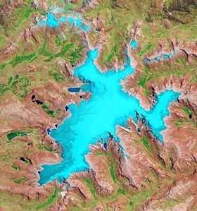 The glaciated Rit'ipampa area (center) and Wanakuni shown in the upper left part of this image (NASA, 2010) | |
| Elevation | 5,200 m (17,100 ft)[1] |
| Location | |
 Wanakuni Peru | |
| Location | Peru, Cusco Region |
| Range | Andes, Willkanuta |
| Coordinates | 13°52′31″S 70°53′24″W / 13.87528°S 70.89000°WCoordinates: 13°52′31″S 70°53′24″W / 13.87528°S 70.89000°W |
Wanakuni (Aymara wanaku, wanaqu guanaco,[2] -ni Aymara suffix to indicate ownership, "the one with the guanaco", hispanicized spelling Huanacune) is a mountain in the Willkanuta mountain range in the Andes of Peru, about 5,200 metres (17,060 ft) high. It is situated in the Cusco Region, Canchis Province, Checacupe District. Wanakuni lies northwest of the glaciated area of Rit'ipampa (Quechua for "snow plain"), southwest of Unu Lluqsina and Millu. T'alla Kunka (Tallacunca) is to the southwest.[1][3]
References
- ↑ 1.0 1.1 escale.minedu.gob.pe - UGEL map of the Carabaya Province (Puno Region)
- ↑ Radio San Gabriel, "Instituto Radiofonico de Promoción Aymara" (IRPA) 1993, Republicado por Instituto de las Lenguas y Literaturas Andinas-Amazónicas (ILLLA-A) 2011, Transcripción del Vocabulario de la Lengua Aymara, P. Ludovico Bertonio 1612 (Spanish-Aymara-Aymara-Spanish dictionary)
- ↑ "Tallacunca Huanacune". IGN, Peru. Retrieved January 31, 2015. see C. Tallacunca and C. Huanacune (two different mountains)