Wanakuni
This article is about the mountain in the Cordillera Apolobamba in Bolivia. For the mountain in the Cordillera Real in Bolivia, see Wanakuni (Sud Yungas). For the mountain in the Cusco Region, Peru, see Wanakuni (Peru).
| Wanakuni | |
|---|---|
 Wanakuni Location in Bolivia | |
| Elevation | 5,796 m (19,016 ft)[1] |
| Location | |
| Location |
Bolivia, La Paz Department, Franz Tamayo Province |
| Range | Andes, Apolobamba mountain range |
| Coordinates | 14°51′S 69°10′W / 14.850°S 69.167°WCoordinates: 14°51′S 69°10′W / 14.850°S 69.167°W[2] |
Wanakuni (Aymara wanaku, wanaqu guanaco,[3] -ni Aymara suffix to indicate ownership, "the one with the guanaco", hispanicized spelling Huanacuni) is a mountain in the Apolobamba mountain range in the Bolivian Andes, about 5,796 metres (19,016 ft) high. It is situated in the La Paz Department, Franz Tamayo Province, Pelechuco Municipality, east of Cololo Lake and northwest of the mountain Qala Phusa (Cololo).[4]
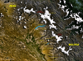
Map of the Apolobamba mountain range showing Cololo Lake. Wanakuni lies east of it and northwest of the mountain Qala Phusa (Cololo).
See also
References
- ↑ "Huanacuni". andes.org.uk. Retrieved 2012-11-30.
- ↑ "Nevado Huanacuni". mapcarta.com. Retrieved 2012-11-30.
- ↑ Radio San Gabriel, "Instituto Radiofonico de Promoción Aymara" (IRPA) 1993, Republicado por Instituto de las Lenguas y Literaturas Andinas-Amazónicas (ILLLA-A) 2011, Transcripción del Vocabulario de la Lengua Aymara, P. Ludovico Bertonio 1612 (Spanish-Aymara-Aymara-Spanish dictionary)
- ↑ John Biggar, Los Andes - Una Guía para Escaladores, p. 130: Map