Wall of Trujillo

The Wall of Trujillo was a Peruvian defensive edification built in the 17th century to protect Trujillo city against attacks from pirates and privateers. It was constructed by viceroy of Melchor de Navarra y Rocafull between 1687 and 1690,[1] it surrounded the current Historic centre of the city. This wall included 15 bastions and 5 gates; The wall was torn down in ends of 19th century allowing the growth of the city, this urban expansion allowed the establishment of new neighborhoods as part of the expansion process of the city.
Some sections of the wall of Trujillo can still be seen today. Parts of the wall has been restored in El Recreo Square at the end of Pizarro Street, in the historic centre, this area now constitutes the public place. Also still are conserved in Spain avenue some fragments of the wall of Trujillo. In America during the colonial era three cities were walled Trujillo, Lima and Cartagena.
History
Due to the proximity of the city with the sea (4 km) and the danger of attack by pirates and privateers, the city wall was built during the viceroy of Melchor de Navarra and Rocafull under the mayor Bartolome Martinez and Fernando Ramirez Jarabeitia Orellana. This was built by the Italian architect Joseph Formento, who began construction on February 19, 1687. Formento was based on design by Leonardo da Vinci to the Italian city of Florence.[2] The wall was designed of elliptical shape to save costs in its construction, which was completed approximately in 1690. The wall reached a perimeter of 5.5 km and involved the use of more than 100,000 bricks. The defensive structure was composed of 15 bastions, 15 shades and 5 gates. This wall lacked moats and Embankments.
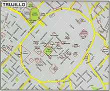
The gate of Huaman was oriented westward to the road to the village of the same name. The gate of Mansiche located to the north, giving way to the highway. The gate of Miraflores faced east. The gate of the Sierra, named after the road leading to this region. Finally the gate of Moche gave access for people coming from the south. In 1942, following the footsteps of the ancient wall, through a master plan, was built Spain Avenue around the area now called Historic Centre of Trujillo.[3]
Current conservation
Some fragments of the wall still remain today as part of the history of the city.
- Bastion Herrera
- Fragment of the wall, located in Spain avenue near the blocks formed by the streets Junín and Estete.
See also
References
- ↑ MINCETUR (ed.). "(spanish)Muralla Militar De Trujillo Colonial - Ministerio de Turismo del Gobierno Peruano". Retrieved October 9, 2012.
- ↑ "(spanish) Trujillo: CENTRO HISTÓRICO". Retrieved October 9, 2012.
- ↑ "(spanish) Ordenanza Reglamentaria de zonificación del Centro Histórico de Trujillo". Retrieved October 9, 2012.
External links
Multimedia
| Wikimedia Commons has media related to Trujillo. |
- Historic Centre of Trujillo by Panoramio, includes information by several authors.
- Colonial Imaages Coloniales of the Historic Centre of Trujillo