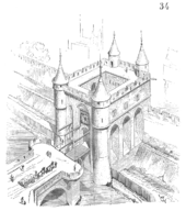
Wall of Charles V

The wall of Charles V, built from 1356 to 1383 is one of the city walls of Paris. It was built on the right bank of the river Seine, outside the wall of Philippe Auguste and replaced it. In the 1640s, the western part of the wall of Charles V was demolished and replaced by the larger Louis XIII wall, with the demolished material reused in the new wall. This new enclosure (enceinte) was totally destroyed in the 1670s and replaced by the Grands Boulevards.
History
The wall of Philippe Auguste
The wall of Philippe Auguste, created at the beginning of the 13th century enclosed 253 hectares with houses, but also fields planted with vegetables and vines allowing people to resist a possible military siege. But after some decades, these fields had been replaced by homes and crops had been pushed outside the city walls. Several suburbs were growing rapidly, particularly in the west. The growing population could no longer be contained in the city. Furthermore, with the Hundred Years War, it became necessary to build a new enclosure to protect the capital of France.
A rampart of fortified earth
.jpeg)
Étienne Marcel, provost of the merchants, began to build an earth rampart from 1356 to 1358, a few hundred yards beyond the wall of Philippe Auguste. Only the right side was affected by this expansion. King Charles V, from 1358, ordered the fortification of it and the addition of a large and deep ditch that would be filled by water from the river Seine.
The new fortification extended westward beyond the Louvre, which lost its function as a fortress. Charles V transformed the Louvre into a residence, but without changing its dimensions. He established a library there with 973 books.
On the east, the new home of the King, the Hotel Saint-Pol, was poorly protected. Charles V decided to build the Chastel Saint-Antoine, that Parisians called the Bastide Saint-Antoine, then la Bastille (Bastide or Bastille is an old French word for castle). In 1370, the provost Hugues Aubriot laid the cornerstone of the building which was completed in 1382.
The city then spread over 440 hectares (1,100 acres) with more than 150,000 inhabitants.
The wall, as well as its extension built by Louis XIII on the west side, was destroyed in 1670, on orders of Louis XIV after his victories in Holland and Germany.
The route

Leaving the Seine between the Pont du Carrousel and the Pont Royal, the wall went to north to the Rue Saint-Honoré at the level of the Palais-Royal then to north-east along the Place des Victoires and the Rue d'Aboukir (opened on the location of the ditch) up to the Porte Saint-Denis. It then followed the Grands Boulevards of today (Boulevard Bonne-Nouvelle, Boulevard Saint-Martin, Boulevard du Temple, Boulevard des Filles du Calvaire, Boulevard Beaumarchais) and then returned to the Seine on the east.
The wall on the left bank of the river, built by Philippe-Auguste was not transformed, leaving the new faubourg Saint-Germain outside the walls.
The gates
The wall on the right bank included only six gates :
- Porte Saint-Honoré (on the Rue Saint-Honoré, about 500 meters outside the wall of Philippe Auguste)
- Porte Montmartre (on Rue Montmartre, at the junction with the rue d'Aboukir)
- Porte Saint-Denis (in its current location)
- Porte Saint-Martin (in its current location)
- Porte du Temple (in the location of the current Place de la République)
- Porte Saint-Antoine (the location of the current Place de la Bastille)
Bibliography
- Danielle Chadych et Dominique Leborgne : Atlas de Paris, Parigramme, 2002, ISBN 2-84096-249-7.
- This page is a translation of its French equivalent.
External links
| Wikimedia Commons has media related to Enceinte de Charles V. |