Walbury Hill
| Walbury Hill | |
|---|---|
 The view from Walbury Hill, looking towards Combe Gibbet | |
| Elevation | 297 m (974 ft) |
| Prominence | c. 188 metres (617 ft) |
| Parent peak | Beacon Batch |
| Listing | Marilyn, County Top, Hardy |
| Location | |
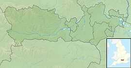 Walbury Hill Walbury Hill in Berkshire | |
| Location | North Wessex Downs AONB, Berkshire, England |
| OS grid | SU373616 |
| Coordinates | 51°21′08″N 1°27′57″W / 51.35226°N 1.46577°WCoordinates: 51°21′08″N 1°27′57″W / 51.35226°N 1.46577°W |
| Topo map | OS Landranger 174 |
Walbury Hill is the highest hill in the traditional county of Berkshire in the UK at 297 metres (974 ft) above sea level. It is also the highest natural point in the South East of England, West Berkshire being a constituent part of the South East of England. It is just 3 metres (10 ft) higher than Leith Hill in Surrey which is the second highest point in the South East.
It is situated on the border between the civil parishes of Inkpen and Combe in southwestern Berkshire (the latter formerly in Hampshire). It is close to the Hampshire border and 7 kilometres (4.3 mi) southeast of Hungerford, the closest town. On its summit is the Iron Age hill fort of Walbury Camp. Combe Gibbet stands on the adjoining Gallows Down.
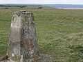
The true summit is marked by a triangulation pillar approximately 100 metres (330 ft) from the main Test Way. Walbury Hill is sometimes used by the BBC as a temporary relay station during major sporting events. There is no metalled road across the hill, but the byway is open to all traffic and maintained with a hard gravel surface, probably because of its use by outside broadcast vehicles. The ridged summit is also popular with paragliding enthusiasts.
It is the start point for both the Test Way and the Wayfarers Walk.
There is also a small low level circular brick building, approximately 6 feet (1.8 metres) high, on the south side of the hill. This appears to be a disused reservoir.
Gallery
-
View to the west with Combe Gibbet centre top on the skyline
-

The South Western Slopes of Walbury Hill
-

View over Southern Berkshire from Walbury Hill Car Park
-

Looking across the crest of the hill towards the area of the longbarrow
| Wikimedia Commons has media related to Walbury Hill. |