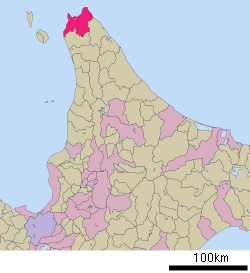
Wakkanai, Hokkaido
| Wakkanai 稚内市 | ||
|---|---|---|
| City | ||
|
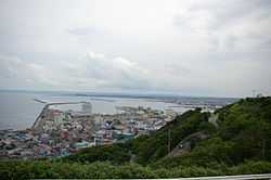
View of Wakkanai from Wakkanai Park | ||
| ||
 | ||
 Wakkanai
| ||
| Coordinates: 45°24′56.4″N 141°40′23″E / 45.415667°N 141.67306°ECoordinates: 45°24′56.4″N 141°40′23″E / 45.415667°N 141.67306°E | ||
| Country | Japan | |
| Region | Hokkaido | |
| Prefecture | Hokkaido | |
| Government | ||
| • Mayor | Hiroshi Kudo (since May 2011) | |
| Area | ||
| • Total | 760.80 km2 (293.75 sq mi) | |
| Population (October 2013) | ||
| • Total | 37,011 | |
| • Density | 48.65/km2 (126.0/sq mi) | |
| Time zone | Japan Standard Time (UTC+9) | |
| - Tree | Sakura, rowan | |
| - Flower | Rosa rugosa | |
| Phone number | 0162-23-6161 | |
| Address | 3-13-15 Chūō, Wakkanai-shi, Hokkaido 097-8686 | |
| Website |
www | |

Wakkanai (稚内市 Wakkanai-shi, Ainu: ヤㇺワッカナイ Yam-wakka-nay meaning 'cold water river'[1]) is a city located in Sōya Subprefecture, Hokkaido, Japan. It is the capital of Sōya Subprefecture and the northernmost city in Japan. It contains Japan's northernmost point, Cape Soya, from which the Russian island of Sakhalin can be seen. As of October 2013, the city has an estimated population of 37,011 and a population density of 48.65 persons per km² (126 persons per mi²). The total area is 760.80 km2 (293.75 sq mi).[2][3]
Wakkanai was originally home to an Ainu population. The first Japanese settlement was established in 1685, and Wakkanai was elevated to city status on April 1, 1949.[2] Wakkanai Airport is located in Wakkanai, whilst JR Hokkaido runs a diesel train service on the Sōya Main Line from Asahikawa to Sapporo.
Geography
Cape Soya is located near Wakkanai, which is on a peninsula jutting towards Sakhalin.
- Rivers: Koetoi River
- Lakes: Ōnuma
Surrounding municipalities
Climate
Wakkanai has the typical humid continental climate (Köppen Dfb) of Hokkaido, with cold winters, warm summers and generally heavy precipitation from the Aleutian Low, whose winds hit the city direct from the Sea of Japan. The mean annual temperature, at 6.5 °C (43.7 °F), is the second lowest for a significant population centre in Japan after Nemuro. Snowfall at 6.6 metres (260 in), the third highest for a big city in Japan after Asahikawa and Aomori and one of the highest anywhere in the world. For comparison, Nain in Canada receives 194 inches (4.9 m) of snow.
The Aleutian Low also makes the sunshine hours the lowest of Japan’s major population centres and in the winter the wind speeds are the highest in Japan with an average of 20.2 km/h (12.6 mph), which adds to the −4.7 °C (23.5 °F) cold of a typical winter day. The city's port is usually usable throughout the year, but does occasionally freeze in cold winters.
| Climate data for Wakkanai (1981–2010) | |||||||||||||
|---|---|---|---|---|---|---|---|---|---|---|---|---|---|
| Month | Jan | Feb | Mar | Apr | May | Jun | Jul | Aug | Sep | Oct | Nov | Dec | Year |
| Average high °C (°F) | −2.7 (27.1) |
−2.5 (27.5) |
1.2 (34.2) |
7.2 (45) |
12.0 (53.6) |
15.7 (60.3) |
19.7 (67.5) |
22.3 (72.1) |
19.7 (67.5) |
13.7 (56.7) |
6.1 (43) |
0.1 (32.2) |
9.4 (48.9) |
| Average low °C (°F) | −6.8 (19.8) |
−7.1 (19.2) |
−3.5 (25.7) |
1.8 (35.2) |
6.0 (42.8) |
10.1 (50.2) |
14.5 (58.1) |
17.3 (63.1) |
14.0 (57.2) |
8.1 (46.6) |
1.0 (33.8) |
−4.2 (24.4) |
4.3 (39.7) |
| Average precipitation mm (inches) | 84.3 (3.319) |
60.7 (2.39) |
50.3 (1.98) |
49.0 (1.929) |
67.6 (2.661) |
53.0 (2.087) |
90.6 (3.567) |
116.0 (4.567) |
123.5 (4.862) |
134.1 (5.28) |
120.9 (4.76) |
112.8 (4.441) |
1,062.8 (41.843) |
| Average snowfall cm (inches) | 173 (68.1) |
143 (56.3) |
102 (40.2) |
21 (8.3) |
0 (0) |
0 (0) |
0 (0) |
0 (0) |
0 (0) |
1 (0.4) |
53 (20.9) |
160 (63) |
653 (257.2) |
| Avg. snowy days | 26.2 | 24.2 | 9.2 | 1.2 | 0 | 0 | 0 | 0 | 0 | 3.4 | 17.7 | 28.2 | 110.1 |
| Average relative humidity (%) | 72 | 72 | 71 | 75 | 79 | 85 | 86 | 84 | 75 | 68 | 67 | 70 | 75.3 |
| Mean monthly sunshine hours | 45.6 | 80.3 | 138.6 | 171.8 | 185.6 | 166.3 | 146.8 | 148.5 | 177.1 | 135.9 | 57.6 | 30.1 | 1,484.2 |
| Source: Japan Meteorological Agency | |||||||||||||
Tourist attractions
The Daisuke Matsuzaka Museum, dedicated to the baseball pitcher "Dice-K" and opened in 2008, is located in Wakkanai, which is his father's hometown.[4]
Sister cities
Domestic
International
-
 Korsakov, Russia
 - Yuzhno-Sakhalinsk, Russia
-
 Baguio City, Philippines
Sister ports
-
 Port of Anchorage, United States[2]
References
- ↑ アイヌ語地名リスト [Ainu Language Place Name List] (PDF) (in Japanese). Office of Ainu Measures Promotion, Department of Environment and Lifestyle, Hokkaido Government. Retrieved January 29, 2015.
- ↑ 2.0 2.1 2.2 稚内市の概要 [Outline of Wakkanai] (in Japanese). Wakkanai, Hokkaido Prefecture, Japan: City of Wakkanai. 2013. Retrieved 2013-11-09.
- ↑ 稚内市の人口と世帯 [Population and Households of Wakkanai] (in Japanese). Wakkanai, Hokkaido Prefecture, Japan: City of Wakkanai. 2013. Retrieved 2013-11-09.
- ↑ ESPN.com article
External links
-
 Wakkanai travel guide from Wikivoyage
 -
 Media related to Wakkanai, Hokkaido at Wikimedia Commons
 - Official website (Japanese)
| ||||||||||||||||||||||||||
|