Wailua River
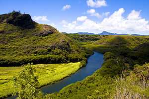
The Wailuā River is a 20-mile-long (32 km)[1] river on the island of Kauaʻi in the U.S. state of Hawaii. It is formed by the confluence of its North and South forks just west of Wailua and enters the Pacific Ocean at 22°2′42″N 159°20′11″W / 22.04500°N 159.33639°WCoordinates: 22°2′42″N 159°20′11″W / 22.04500°N 159.33639°W. It is the only navigable river (by boats larger than kayaks) in the Hawaiian Islands. It is a center of activity for locals and visitors in the form of boat tours to Fern Grotto, kayaking and water skiing.
The North Fork begins near the Mount Waiʻaleʻale at coordinates 22°3′35″N 159°29′33″W / 22.05972°N 159.49250°W and flows 12.2 miles (19.6 km)[1] east to its junction with the South Fork. The South Fork forms at the junction of several streams southwest of Hanamaulu and flows 8.1 miles (13.0 km) east,[1] over Wailua Falls, to its junction with the North Fork.
Other points of interest along the river system include a bird refuge, Kamokila Hawaiian Village, Secret Falls and a pool with a rope swing.
See also
References
- ↑ 1.0 1.1 1.2 U.S. Geological Survey. National Hydrography Dataset high-resolution flowline data. The National Map, accessed April 28, 2011
- U.S. Geological Survey Geographic Names Information System: Wailua River
- Pukui and Elbert (2004). "lookup of Wilua". on Place Names of Hawai'i. Ulukau, the Hawaiian Electronic Library, University of Hawaii. Retrieved 2009-11-30.