Waghäusel
| Waghäusel | ||
|---|---|---|
|
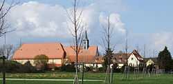
Monastery | ||
| ||
 Waghäusel | ||
| Coordinates: 49°15′N 8°31′E / 49.250°N 8.517°ECoordinates: 49°15′N 8°31′E / 49.250°N 8.517°E | ||
| Country | Germany | |
| State | Baden-Württemberg | |
| Admin. region | Karlsruhe | |
| District | Karlsruhe | |
| Government | ||
| • Mayor | Walter Heiler (SPD) | |
| Area | ||
| • Total | 42.84 km2 (16.54 sq mi) | |
| Population (2012-12-31)[1] | ||
| • Total | 19,981 | |
| • Density | 470/km2 (1,200/sq mi) | |
| Time zone | CET/CEST (UTC+1/+2) | |
| Postal codes | 68743–68753 | |
| Dialling codes | 07254 | |
| Vehicle registration | KA | |
| Website | www.waghaeusel.de | |

Waghäusel (German pronunciation: [ˈvak.hɔʏzəl], locally [ˈvak.hɔusɛl]) is a German town located in the Rhine valley in the south-western state of Baden-Württemberg. Waghäusel consists of 3 townships which are the core city (1236 residents), Kirrlach (9347 residents), and Wiesental (9596 residents) [as of March 31, 2006]. Wiesental and Kirrlach are located on Bertha Benz Memorial Route.
Among the 3 townships, Wiesental occupies the largest land area of 21.2 km² followed by Kirrlach with 19.4 km² and the core city with 0.22 km².
Sights
- Pilgrimage church of Mary with monastery
- Baroque castle "Eremitage"
- Daytaller House in Kirrlach
- Gothic wood carved altar in the Catholic Church of Kirrlach
- Old-German wine tavern in Kirrlach (liquor licence since July 15, 1700)
International relations
Main article: List of twin towns and sister cities in Germany
Waghäusel is twinned with the following towns:
References
- ↑ "Gemeinden in Deutschland mit Bevölkerung am 31.12.2012 (Einwohnerzahlen auf Grundlage des Zensus 2011)". Statistisches Bundesamt (in German). 12 November 2013.
External links
- (German) Official Waghäusel web site
- (German) Pilgrimage church of Mary with monastery