Wüstegarten
| Wüstegarten | |
|---|---|
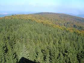 Aerial view over Wüstegarten (mountain). | |
| Elevation | 675.3 m (2,216 ft) |
| Location | |
| Location | Landkreis Waldeck-Frankenberg and Schwalm-Eder-Kreis (districts), Hesse, Germany |
| Range | Kellerwald |
| Coordinates | 51°00′59″N 09°05′03″E / 51.01639°N 9.08417°ECoordinates: 51°00′59″N 09°05′03″E / 51.01639°N 9.08417°E |
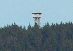
Forest and lookout tower on the mountain
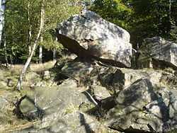
Rock outcroppings and native vegetation of Wüstegarten.
Wüstegarten is a mountain in the counties of Waldeck-Frankenberg and Schwalm-Eder-Kreis in the north of the German state of Hesse. It is in the Kellerwald mountains and has an elevation of 675.3 metres (2,216 ft).
The mountain is within the Kellerwald-Edersee National Park, Hesse's only national park. Activities include hiking, nordic walking, mountain biking, and cross-country skiing.
References
- Grieben-Reiseführer: Oberhessen, Kurhessen und Waldeck. Band 230, Karl Thiemig Verlag, Munich, 1981, p. 160.
- Eduard Brauns: Wander- und Reiseführer durch Nordhessen und Waldeck. Bernecker Verlag, Melsungen, 1971, p. 180.
- Karl E. Demandt: Geschichte des Landes Hessen. Johannes Stauda Verlag, Kassel, 1980, pp. 88 and 89
See also
| Wikimedia Commons has media related to Wüstegarten. |
- List of mountains of Hesse