Wädenswil–Vorder Au
Wädenswil–Vorder Au is one of the 111 serial sites of the UNESCO World Heritage Site Prehistoric pile dwellings around the Alps, of which are 56 located in Switzerland.[1][2]
Geography
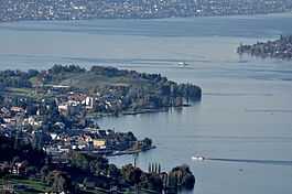
The site is located at the Au peninsula on Zürichsee lakeshore in Au, a locality of the municipality of Wädenswil in the Canton of Zürich in Switzerland. Because the lake has grown in size over time, the original piles are now around 4 metres (13 ft) to 7 metres (23 ft) under the water level of 406 metres (1,332 ft). The settlement comprises 1.49 hectares (3.68 acres), and the buffer zone including the lake area comprises 22.5 hectares (55.60 acres) in all.
Description
Located on the Au peninsula, the site has yielded special pottery from the transitional period between the Pfyn and Horgen cultures. The Corded Ware settlement phase contained a bell beaker, which allowed to draw conclusions on the links between the Corded Ware and Bell Beaker cultures. Since it has yielded a special type of pottery, the Early Bronze Age settlement phase is also important, and helps trace the distribution of Arbon style pottery in the region during the 17th century BC.[3]
Swiss inventory of cultural property of national and regional significance
As well as being part of the 56 Swiss sites of the UNESCO World Heritage Site Prehistoric pile dwellings around the Alps, the settlement is also listed in the Swiss inventory of cultural property of national and regional significance as a Class object.[4]
See also
Literature
- Peter J. Suter, Helmut Schlichtherle et al.: Pfahlbauten – Palafittes – Palafitte. Palafittes, Biel 2009. ISBN 978-3-906140-84-1.
- Beat Eberschweiler: Ur- und frühgeschichtliche Verkehrswege über den Zürichsee: Erste Ergebnisse aus den Taucharchäologischen Untersuchungen beim Seedamm. In: Mitteilungen des Historischen Vereins des Kantons Schwyz, Volume 96, Schwyz 2004.[5]
External links
References
|
|---|
| | | | Settlements | | |
|---|
| | Islands | |
|---|
| | Rivers | |
|---|
| | Valleys | |
|---|
| | Mountains | |
|---|
| | Landmarks | |
|---|
| | Transportation | |
|---|
| | People | |
|---|
|
Coordinates: 47°14′48.88″N 8°39′11.64″E / 47.2469111°N 8.6532333°E / 47.2469111; 8.6532333