Vranje
| Vranje Врање | |||
|---|---|---|---|
| City | |||
|
Vranje from the hill | |||
| |||
 Location of the municipality of Vranje within Serbia | |||
| Coordinates: 42°33′N 21°54′E / 42.550°N 21.900°ECoordinates: 42°33′N 21°54′E / 42.550°N 21.900°E | |||
| Country | Serbia | ||
| District | Pčinja | ||
| Settlements | 105 | ||
| Government | |||
| • Mayor | Zoran Antić (SPS) | ||
| Area[1] | |||
| • Municipality | 860 km2 (330 sq mi) | ||
| Population (2011 census)[2] | |||
| • Town | 55,138 | ||
| • Municipality | 83,524 | ||
| Time zone | CET (UTC+1) | ||
| • Summer (DST) | CEST (UTC+2) | ||
| Postal code | 17000 | ||
| Area code | +381 17 | ||
| Car plates | VR | ||
| Website |
www | ||


Vranje (Serbian: Врање, Vranje, pronounced [ʋrâɲɛ]) is a city located in southern Serbia. The population of the city administrative area is 83,524, while the urban area has 55,138 people. It is the administrative center of the Pčinja District of Serbia and the southernmost settlement which is in an official category of a city (grad). It is located on the Pan-European Corridor X, close to the borders with Macedonia and Bulgaria.
Name and history
There is no reliable information on the precise location or time of early settlements on which Vranje developed. It is assumed that it originated during either Roman or Greek dominance, and that the region itself was inhabited by various Ilyrian and Thracian tribes. The region, in any case, where Vranje is located was very important, because many caravan roads and armies who went north passed through Vranje valley.
The Romans conquered the region in the 2nd or 1st centuries BC. Vranje was part of Moesia Superior and Dardania during the Roman rule. The Roman fortresses in the Vranje region was abandoned during the Hun attacks in 539–544 AD, these include the localities of Kale at Vranjska Banja, Gradište in Korbevac and Gradište in Prvonek.[3]

Modern name stems from the old word for "black" ("vran") in the Serbian language and first appears in the Alexiad by Byzantine princess and scholar Anna Comnena (1083–1153):
"Thereupon Bolcanus grew bold, as no opponent was left, and devastated the surrounding lands and towns; laid the country outside Scopia in ruins and even burnt some of it. As if this was not enough, he even seized Polobus, and proceeding to Branea laid that all waste, carried off a tremendous amount of plunder from it and then returned to his own country."[4]
In the 1193. Vranje was seized by the Grand Prince Stefan Nemanja from the Byzantines. However, soon afterward he retreated. Vranje definitely entered Serbian state in 1207 when it was conquered by Stefan the First-Crowned.
During the fall of the Serbian Empire, Vranje was independent under Uglješa Vlatković, ‘’the Lord of Vranje, Preševo and Kumanovo.’’ Uglješa Vlatković became vassal of Stefan Lazarević, after the Battle of Tripolje, so Vranje became part of Serbian Despotate.

Ottomans conquered Vranje on 14. June 1455. The town held important position during their rule and many wealthy Muslims lived in Vranje and they had built several mosques, Amam and residence of the pashas – Pašin konak. The town was part of the Sanjak of Niš.[5] Vranje was under Ottoman rule for 422 years and was liberated by the Serbian army under the command of general Jovan Belimarković. During this time city had around 8000 residents, mostly Serbs.
In the early 20th century, Vranje had around 12000 inhabitants. As a border town of the Kingdom of Serbia, it was used as the starting point for the Četniks and Komitas who fought against the Ottomans in the Old Serbia.
In the First Balkan war, Main headquarters of the Serbian army was situated in the town and King Peter I Karađorđević, Prime Minister Nikola Pašić and the Chief of staff General Radomir Putnik stayed in the town.

In the First World War, Vranje was conquered by the Kingdom of Bulgaria on 16/17 October 1915. Bulgarians implemented Bulgarisation against non-Bulgarian population of Vranje and committed numerous war crimes.
After the war, Vranje was part of the Kingdom of Serbs, Croats and Slovenes in one of the 33 oblasts and in 1929, it became part of the Vardar Banovina. During the Second World War, German Nazis entered the town on 9. April 1941 and transferred it to Bulgarians on 22. April 1941. During the Bulgarian rule, 400 Serbs was shot and around 4000 Serb patriots was interned. Vranje was liberated by the Yugoslav People's Army on 7. September 1944.
Vranje became part of the Pčinja District in the new Yugoslavia and in the 1960s and 1970s it was industrialized. During the 1990s, the economy of Vranje was heavily affected by the Sanctions against Yugoslavia and 1999 NATO bombing.
Geography


Vranje is the economic, political and cultural center of Pčinja District consisting of Bosilegrad, Bujanovac, Vladičin Han, Preševo, Surdulica, Trgovište and Vranje municipalities. The city is located in the southwest of Vranje valley, on the left bank of the South Morava river. The river and the city are divided by the main road and railway line, which leads: to the north Leskovac (70 km), Niš (110 km) and Belgrade (347 km), and to the south: Kumanovo (56 km), Skopje (91 km) and Thessalonica (354 km).
Vranje is located at base of the mountains Pljačkovica (1231 m), Krstilovice (1154 m) and Pržar (731 m) and it is located 70 km (43 mi) away from the border with Bulgaria, 40 km (25 mi) from the border with the Macedonia.
Eparchy of Vranje is located in the city and the 4th Land Force Brigade of the Serbian army is stationed is located there.
| Climate data for Vranje (1981–2010, extremes 1961–2010) | |||||||||||||
|---|---|---|---|---|---|---|---|---|---|---|---|---|---|
| Month | Jan | Feb | Mar | Apr | May | Jun | Jul | Aug | Sep | Oct | Nov | Dec | Year |
| Record high °C (°F) | 17.9 (64.2) |
22.4 (72.3) |
26.3 (79.3) |
31.5 (88.7) |
33.3 (91.9) |
37.9 (100.2) |
41.6 (106.9) |
39.6 (103.3) |
35.6 (96.1) |
30.6 (87.1) |
26.1 (79) |
18.7 (65.7) |
41.6 (106.9) |
| Average high °C (°F) | 4.2 (39.6) |
6.8 (44.2) |
12.2 (54) |
17.3 (63.1) |
22.5 (72.5) |
26.1 (79) |
28.7 (83.7) |
29.1 (84.4) |
24.2 (75.6) |
18.4 (65.1) |
10.8 (51.4) |
5.1 (41.2) |
17.1 (62.8) |
| Daily mean °C (°F) | −0.1 (31.8) |
1.8 (35.2) |
6.4 (43.5) |
11.2 (52.2) |
16.0 (60.8) |
19.5 (67.1) |
21.6 (70.9) |
21.6 (70.9) |
16.9 (62.4) |
11.8 (53.2) |
5.7 (42.3) |
1.2 (34.2) |
11.1 (52) |
| Average low °C (°F) | −3.6 (25.5) |
−2.6 (27.3) |
1.1 (34) |
5.0 (41) |
9.4 (48.9) |
12.6 (54.7) |
14.1 (57.4) |
14.1 (57.4) |
10.3 (50.5) |
6.2 (43.2) |
1.5 (34.7) |
−2.1 (28.2) |
5.5 (41.9) |
| Record low °C (°F) | −25.0 (−13) |
−22.0 (−7.6) |
−13.0 (8.6) |
−6.6 (20.1) |
0.0 (32) |
2.3 (36.1) |
5.0 (41) |
4.5 (40.1) |
−2.4 (27.7) |
−7.0 (19.4) |
−12.6 (9.3) |
−18.0 (−0.4) |
−25.0 (−13) |
| Average precipitation mm (inches) | 35.4 (1.394) |
38.3 (1.508) |
38.2 (1.504) |
52.0 (2.047) |
56.3 (2.217) |
63.2 (2.488) |
44.7 (1.76) |
43.2 (1.701) |
46.7 (1.839) |
52.4 (2.063) |
57.4 (2.26) |
50.5 (1.988) |
578.3 (22.768) |
| Avg. precipitation days (≥ 0.1 mm) | 12 | 12 | 12 | 12 | 13 | 10 | 8 | 7 | 9 | 9 | 12 | 14 | 131 |
| Average relative humidity (%) | 81 | 75 | 67 | 64 | 65 | 65 | 61 | 60 | 67 | 73 | 79 | 83 | 70 |
| Mean monthly sunshine hours | 73.8 | 100.7 | 151.3 | 176.2 | 230.5 | 274.3 | 316.1 | 294.8 | 209.8 | 153.4 | 87.5 | 55.5 | 2,123.9 |
| Source: Republic Hydrometeorological Service of Serbia[6] | |||||||||||||
Culture and tourism

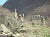

Vranje was an important Ottoman trading site. The White Bridge is a symbol of the city and is called "most ljubavi" (Lovers bridge) after the tale about the forbidden love between the Muslim girl Ajša and Christian Stojan that resulted in the father killing the couple. After that, he built the bridge where he had killed her and had the story in-scripted in Ottoman Arabic. The 11th-century Markovo Kale fortress is in the north of the city. The city has traditional Balkan and Ottoman architecture.
The well-known theater play Koštana by Bora Stanković is placed in Vranje. Vranje is famous for its popular, old music, lively and melancholic at the same time. The best known music is from the theater piece with music, "Koštana", by Bora Stanković. This original music style has been renewed recently by taking quite different and quite specific, and more oriental form, with the contribution of rich brass instruments. It is played particularly by the Vranje Romani people.
Institutions
- National Museum, (in former Pasha's residence, built in 1765)
- Youth Cultural Centre
- National Library
- Centre for Talents
- Theater "Bora Stankovic"
Vranje is the seat of Pčinja District and as such is a major center for cultural events in the district. Most notable annual events are: Borina nedelja, Stari dani, Dani karanfila (in Vranjska Banja)... Vranje lies close to Besna Kobila mountain and Vranjska Banja, two locations with high potential which are currently underdeveloped. Other locations in and around Vranje with some tourist potential include Prohor Pčinjski monastery, Kale-Krševica, Markovo kale, Pržar, birth-house museum of Bora Stankovic.
Largest hotels are Hotel "Vranje", located near the center and Hotel "Pržar" overlooking the city and the valley. The city has numerous traditional Serbian cuisine as well as international cuisine restaurants and many cafes and bars.
Economy

Vranje is located in southern Serbia, on Corridor X near the border with Macedonia and Bulgaria. Distance from Thessalonica international harbor is 285 km (177 mi)and distance from the international airports of Skopje and Niš are 90 km (56 mi). Thanks to the excellent transport connections of Vranje, anyone can easily access the markets of southeastern Europe (CEFTA) and the European Union, with all the tax reliefs that Serbia have with these markets. Vranje has a long tradition of industrial production, trade, and tourism and is rich in natural resources, such as forests and geothermal resources.[7] Until the second half of the 20th century Vranje was a craftsman town. The crafts included: weaving, water-milling, and carriages craft. With the beginning of industrialization in the 1960s, many of these crafts disappeared. In those years, many factories were opened, such as the Tobacco Industry of Vranje (Дуванска индустрија Врање), Simpo, Shoe factory Koštana, cotton plant Yumco, industry of technical goods Alfa Plam, SZP Zavarivač Vranje. In 1961 there were 1525 employees, in 1971, 4374 employees and in 1998, a total of 32,758 employees, of which 28,347 were in business and 4,411 outside of it.
After the Bulldozer revolution in 2000, the number of employees began to drop, due to the closure of many factories like Yumco and Koštana. Employees in 2010 numbered 18,958 and there were 7559 unemployed people. The entire city of Vranje has 59,278 available workers. In Vranje the most common industries are: timber industry, clothing, footwear and furniture, food and beverages, agricultural, textile industry, chemical industry, construction industry, machinery and equipment, and business services. In Vranje there are more than 2,500 small and medium size companies. To potential investors there several industrial sites are available, with plan documents and furnished infrastructure. Among the companies with business locations in the city are: British American Tobacco, Simpo, Sanch, Kenda Farben, Danny style, OMV and Hellenic Petroleum.[7]
In 2010 the City council passed the "Strategy of sustainable development of the city of Vranje from 2010 to 2019," for the achievement of objectives through a transparent and responsible business partnership with industry and the public.[7]
Famous or notable citizens

- Borisav (Bora) Stanković (* 31 March 1875, Vranje; † 22 October 1927, Belgrade), a Serbian writer.
- Miroslav-Cera Mihajlović, contemporary poet.
- Jovan Hadži-Vasiljević, (1866–1946), historian.
- Djordje Tasić, (1892–1943), one of the most notable Serbian jurists.
- Justin Popović (1894–1979), theologian and philosopher.
- Physicians: Dr. Franjo Kopsa († 1898); Dr. Dragoljub Mihajlović († 1980).
- Scientists: Dejan Stojković (Ph.D. physics, professor in USA), Marjan Bosković, (MD), anatomy professor; Dragan Pavlović, (MD), professor of pathophysiology and anesthesiology; Dragoslav Mitrinović, mathematician.
- Painters: Jovica Dejanović, Miodrag Stanković-Dage, Zoran Petrusijević-Zop, Suzana Stojanović.
- Musicians: Bakija Bakić († 1989), Staniša Stošić († 2008), Čedomir Marković
- Aleksandar Davinić: journalist, satirist.
- Curators: Jelena Veljković, Marko Stamenković.
- Architects: Milan Stamenković (Moscow Architectural Institute State Academy)
- Milan Aleksic: La percuzza
Demographics
Population of Vranje has been permanently refreshed by the newcomers from its surroundings as well by the Serb refugees who emigrated from Kosovo and Metohija during the last 2 decades. The last wave of emigration was in 1999, following the 1999 NATO bombing of Yugoslavia.
Ethnic composition of the municipality:
| Ethnic group | Urban population | Municipality population |
|---|---|---|
| Serbs | 54,450 | 76,569 |
| Roma | 4,125 | 4,654 |
| Bulgarians | 487 | 589 |
| Macedonians | 223 | 255 |
| Others | 1,200 | 1,457 |
| Total | 60,485 | 83,524 |
Population of the municipality in history:
- 1093: 3,900 (First appears in the Alexiad by Byzantine princess and scholar Anna Comnena)
- 1386: 5,800 (Vranje was capital of Caesar Ugljesa′s country)
- 1800: 10,654
- 1878: 15,875
- 1900: 27,586
- 1905: 34,110
- 1910: 39,487
- 1921: 43,221
- 1931: 48,817
- 1941: 53,000 (Estimate)
- 1948: 32,472
- 1953: 49,690
- 1961: 54,261
- 1971: 65,959
- 1981: 76,094
- 1991: 85,122
- 2002: 94,052
- 2011: 83,524
International relations
Twin towns – sister cities
Vranje is twinned with:
Municipalities and settlements
The city of Vranje includes two municipalities: Vranje and Vranjska Banja.[9]
Municipal area of two municipalities of Vranje includes the following settlements:
|
|
See also
External links
| Wikimedia Commons has media related to Vranje. |
References
- ↑ "Municipalities of Serbia, 2006". Statistical Office of Serbia. Retrieved 2010-11-28.
- ↑ "2011 Census of Population, Households and Dwellings in the Republic of Serbia: Comparative Overview of the Number of Population in 1948, 1953, 1961, 1971, 1981, 1991, 2002 and 2011, Data by settlements" (PDF). Statistical Office of Republic Of Serbia, Belgrade. 2014. ISBN 978-86-6161-109-4. Retrieved 2014-06-27.
- ↑ Janković, Đorđe. "The Slavs in the 6th century North Illyricum". Projekat Rastko (in Serbian). Belgrade. Retrieved 29 September 2013.
Trial excavations of early Byzantine forts, conducted around Vranje in 2003, show that they were abandoned as early as in the course of the 6th century. These are the localities of Kale above Vranjska Banja and Gradište in Korbevac (Радичевић, Стојчић et al. 2004). Judging by surface findings, the case is the same with Gradište in Prvonek east of Vranjska Banja. The general impression is that all these forts are single-layered – that they were built and demolished at the same time. The same roofing tiles on all three sites, the thinness of the cultural layer and the similarity of pottery show this. The absence of animal bones is notable. Kale was destroyed in a fire, whereas Gradište conveys the impression of having been abandoned. The found pottery fragments are similar to others from North Illyricum, dated to the second and third quarter of the 6th century; there is no such pottery in the strata of the time of the reconstruction of Emperor Mauritius (Јанковић 1981: 141-147; Bjelajac 1990: 163-168). There are no data for the duration of other forts around Vranje, except for Kale at Klinovac, where a hoard was found with the latest coins from 544 (Гaj – Поповић 1973: 25-32). According to the inventory of the National Museum in Vranje, Markovo Kale was used in the 6th century, and later finds are not known. Kale at Veliki Trnovac to the South of Vranje (Чершков 1986) seems to have been the centre of this area in the early Byzantine period, judging by the basilica, undoubtedly episcopal, with rich marble decoration, which is also in Vranje; there are no data suggesting its usage in the late 6th or early 7th century.
- ↑ Comnena, Anna. "Book IX". The Alexiad. Retrieved 8 September 2013.
- ↑ Godišnjak grada Beograda. Museum of the Belgrade. 1977. p. 116. Retrieved 11 July 2011.
- ↑ "Monthly and annual means, maximum and minimum values of meteorological elements for the period 1981–2010" (in Serbian). Republic Hydrometeorological Service of Serbia. Retrieved April 9, 2015.
- ↑ 7.0 7.1 7.2 Агенција за страна улагања и промоцију извоза Републике Србије (СИЕПА) – Град Врање
- ↑ "Miasta partnerskie i zaprzyjaźnione Nowego Sącza". Urząd Miasta Nowego Sącza (in Polish). Archived from the original on 23 May 2013. Retrieved 1 August 2013.
- ↑ http://media.popis2011.stat.rs/2011/prvi_rezultati.pdf


| ||||||||||||||