Votanikos
| Votanikos Βοτανικός | |
|---|---|
| Neighborhood | |
|
Iera Odos in Votanikos | |
 Votanikos Location in Athens | |
| Coordinates: 37°58′53″N 23°42′22″E / 37.98139°N 23.70611°ECoordinates: 37°58′53″N 23°42′22″E / 37.98139°N 23.70611°E | |
| Country | Greece |
| Region | Attica |
| City | Athens |
| Website | www.cityofathens.gr |
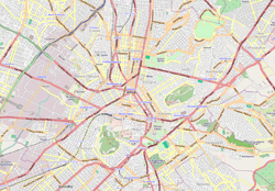
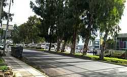
Votanikos (Greek: Βοτανικός; pronounced [votaniˈkos]) is a subdivision located 3 km west of the downtown part of the Greek capital of Athens. The area is named after a nearby botanical garden situated to the southwest (Athens Botanical Gardens). The eastern part are residential, the western part are forested and industrialized. The subdivision has no squares but has a nearby school. Major streets bordering this subdivision includes Patsi Street to the west, Athinon Avenue to the north, Konstantinopouleos Avenue and the rail to the south and Petrou Ralli Avenue to the south. The Iera Odos runs in the middle. The population is around 5,000–6,000 people and the area is about 0.5 km².
Neighboring subdivisions
- Akadimia Platonos, north
- Profitis Daniil, northeast
- Asyrmatos, south
- Kato Petralona, south
History
The area saw housing developments in the early part of the 20th century when Athens' began to grow as well as an industrial being added, the area after World War II and the Greek Civil War saw taller buildings to be added.
Residential streets
Here is a list of residential streets, several of which are named after places in Northern Greece as well as Pelagonia and Falaisias. Neighborhood streets runs from NNW to SSE and from SSW to NNE. This list excludes major streets which are mentioned on the top. There are 287 streets and avenues as well as one connector in this subdivision.
- Agias Markelas Street
- Agiou Orous Street
- Agistis Street
- Aimou Street
- Chalkidikis Street
- Doxatou Street
- Falaisias Street
- Flioudos Street
- Grevenon Street
- Karyon Street
- Kastorias Street
- Korytsas Street
- Naoussas Street
- Nevrokopiou Street
- Pangaio Street
- Pelagonias Street
- Pellis Street
- Protifi Daniil Street
- Rodopis Street
- Troizinas Street
- Volissou Street
- Vourbiani Street
