Volcán de Agua
| Volcán de Agua | |
|---|---|
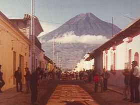 Volcán de Agua, seen from Antigua, Guatemala, with temporary street carpeting for Easter celebrations in foreground. | |
| Elevation | 3,760 m (12,340 ft)[1] |
| Translation | Volcano of Water (Spanish) |
| Location | |
 Volcán de Agua | |
| Coordinates | 14°27′54″N 90°44′35″W / 14.46500°N 90.74306°WCoordinates: 14°27′54″N 90°44′35″W / 14.46500°N 90.74306°W[1] |
| Geology | |
| Type | Stratovolcano |
| Volcanic arc/belt | Central America Volcanic Arc |
| Last eruption | Unknown[1] |
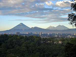
Volcán de Agua (also known as Hunahpú by Mayans) is a stratovolcano located in the department of Sacatepéquez in Guatemala. At 3,760 m (12,340 ft), Agua Volcano towers more than 3,500 m (11,500 ft) above the Pacific coastal plain to the south and 2,000 m (6,600 ft) above the Guatemalan Highlands to the north. It dominates the local landscape except when hidden by cloud cover. The volcano is within 5 to 10 km (3.1 to 6.2 mi) of the city of Antigua Guatemala and several other large towns situated on its northern apron. These towns have a combined population of nearly 100,000. It is within about 20 km of Escuintla (population, ca .100,000) to the south.[2] Coffee is grown on the volcano's lower slopes.
The local Kaqchikel people have always called the volcano Hunapú "place of flowers" or Jun Ajpu' "one hunter (The calendar date for the sacred site; a typical method for naming sacred sites in Mayan cosmovision)" in current Kaqchikel orthography. The Spanish conquistadors also called it Hunapú until a lahar from the volcano in 1541 destroyed the original capital of Guatemala (now known as Ciudad Vieja) and the city was moved to the current site of Antigua Guatemala following this disaster. Among the casualties was the governor Beatriz de la Cueva.[3] As the lahar produced a destructive flood of water, this prompted the modern name "Volcán de Agua" meaning "Volcano of Water", in contrast to the nearby "Volcán de Fuego" or "Volcano of Fire". The Kaqchikels call Volcan de Fuego Chi Gag, which translates to "where the fire is" or Chi Q'aq' in current Kaqchikel orthography.
The volcano has not had any historical eruptions,[1] but it has the potential to produce debris flows and lahars that could inundate nearby populated areas.[2]
The volcano was last blanketed by snowfall in January 1967.
The Volcán de Agua has been declared a protected area in 1956 and covers an area of 12,600 Ha.[4]
On January 21, 2012, 12,000 Guatemalans formed a human chain all the way to the peak Volcan de Agua in a protest against domestic violence. [5]
Gallery
-
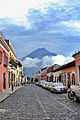
Agua from near Antigua Guatemala's Central Park.
-
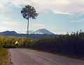
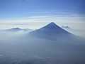
Agua as seen from the road from Chimaltenango to Antigua
-
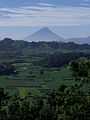
Volcan de Agua as seen from Tecpan, Guatemala (80 km away)
-
Volcan de Agua exhibits the steep cone shape typical of stratovolcanoes; as seen from Acatenango's Pico Mayor.
-
See also
- List of volcanoes in Guatemala
- Mountain peaks of North America
- List of stratovolcanoes
Notes
- ↑ 1.0 1.1 1.2 1.3 "Agua". Global Volcanism Program. Smithsonian Institution.
- ↑ 2.0 2.1 S.P. Schilling, J.W. Vallance, O. Matías, and M.M. Howell, 2001, Lahar Hazards at Agua Volcano, Guatemala: USGS Open-File Report 01-432
- ↑ "Conquered Conquistadors", Florine G.L. Asselbergs, First Edition, published 2004
- ↑ CONAP. "Listado de Áreas Protegidas (enero, 2011)" (xls) (in Spanish). conap.gob.gt. Retrieved 2011-06-14.
- ↑ http://www.bbc.co.uk/news/world-latin-america-16669818
External links
| Wikimedia Commons has media related to Volcán de Agua. |
- Ideal Pictures Corp. Menace of Guatemala (Ideal What-Nots series), 1934 documentary now in the public domain. Hosted at the Internet Archive. The narrator has a patronizing attitude to Guatemalans, but the footage is interesting.
- "Volcán de Agua, Guatemala" on Peakbagger
| |||||||||||||||||||||||||||||