Voi
- For other meanings see Voi (disambiguation).
| Voi | |
|---|---|
| Municipality & Town | |
|
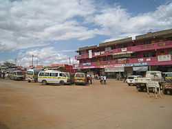
Voi town center. | |
 Voi Location in Kenya | |
| Coordinates: 03°23′26″S 38°34′37″E / 3.39056°S 38.57694°ECoordinates: 03°23′26″S 38°34′37″E / 3.39056°S 38.57694°E | |
| Country | Kenya |
| Province | Coast Province |
| County | Taita-Taveta County |
| Location | Voi Location |
| Town | 1932 |
| Elevation[1] | 580 m (1,900 ft) |
| Population (2009)[2] | |
| • Municipality & Town | 45,483 |
| • Urban | 17,152 |
| • Rural | 28,331 |
| Time zone | EAT (UTC+3) |
Voi is the largest town in Taita-Taveta County in southern Kenya, Coast Province. It lies at the western edge of the Taru Desert, south and west of the Tsavo East National Park. The Sagala Hills are to the south. Voi is also a municipality.
Economy

Voi is a marketplace for the agricultural and meat products from the fertile Taita Hills as well as other surrounding areas.[1] Voi's town centre consists of mostly general stores, shops, markets, kiosks and a few hotels. Most lodges that service tourists for the national park are located in the suburbs at the edge of town. The Voi Sisal Estates are located to the west of the town. A large squatter community exists in the Mwatate Sisal Estates, also to the west of town.[3]
History
According to local history the name of town comes from a slave trader called Chief Kivoi who settled near the Voi River about 400 years ago. There after the village grew as a trading centre for the local Taita people with other Kenyan tribes and Arabs.
The town started to grow at the end of the 19th century when the Uganda Railway was constructed. People started to move in to work on the railway and the nearby sisal estates.[4] However, township status with an area of about 16.27 square kilometres (6.28 sq mi)[5] was not granted until 1932. The town has long since outgrown the original grant.[1]
Climate
| Climate data for Voi | |||||||||||||
|---|---|---|---|---|---|---|---|---|---|---|---|---|---|
| Month | Jan | Feb | Mar | Apr | May | Jun | Jul | Aug | Sep | Oct | Nov | Dec | Year |
| Average high °C (°F) | 32 (90) |
33 (92) |
33 (91) |
31 (88) |
29 (85) |
28 (83) |
28 (82) |
28 (82) |
29 (84) |
31 (88) |
31 (88) |
31 (88) |
30.3 (86.8) |
| Average low °C (°F) | 21 (69) |
21 (69) |
21 (70) |
21 (70) |
20 (68) |
18 (65) |
17 (63) |
17 (63) |
17 (63) |
19 (66) |
20 (68) |
21 (69) |
19.4 (66.9) |
| Average precipitation mm (inches) | 33 (1.3) |
30 (1.2) |
80 (3) |
97 (3.8) |
33 (1.3) |
8 (0.3) |
3 (0.1) |
8 (0.3) |
13 (0.5) |
23 (0.9) |
97 (3.8) |
130 (5.1) |
555 (21.6) |
| Source: Weatherbase[6] | |||||||||||||
Transport
Train
Voi is at the junction of the feeder Kenya-Uganda Railway to Taveta, Kenya and Arusha, Tanzania with the main line between Nairobi and Mombasa and thus has a major railway station.
Taxi
Taxis can be found in the town centre. Fares are negotiated, not regulated.
Matatu
Matatus (Minibus/Sharetaxis) run between the town centre and surrounding areas. There are also matatus traveling to Nairobi, Mombasa, Wundanyi, Taveta and other places.
Bus
Akamba, Coast and Mash are among many bus companies that run day and night buses to Mombasa and Nairobi. All booking offices are located in the town center.
Air
The Ikanga Air Strip is nearby.
- Other forms of transport include tuk tuks and motorbikes which operate 24/7 and are very cheap.
Municipality
The municipality of Voi is larger than the town, and includes the same area as the Voi Location.[1] It includes the villages of Ikanga and Mkwachunyi. The municipality is governed by the Voi Municipal Council, the local authority, and is not subject to the Taita-Taveta County Council.[7] The Voi Municipal Council is headed by a Mayor.
Electoral Wards
The Municipality is divided into six wards, each ward electing one councilor
- Kighononyi
- Kirutai
- Voi Central Ward
- Voi North-East Ward
- Voi South Ward
- Voi West Ward
Municipal Council
The Voi Municipal Council is made up of six Councillors elected by each ward and four at-large councillors making a total of ten councilors.
The current sitting councilors are:
- His Worship Councillor Thomas K. Mwatela - Mayor
- Councilor Msengo Stephen Kayanda
- Councilor Mwawughanga Purity
- Councilor Ochieng Eric
- Councilor Mwadime Priscillah
- Councilor Mwakio Hope Sanguli
- Councilor Mohamed Juma
- Councilor Mwariwa Rachel
- Councilor Kidoki Hamisi
Tourism and entertainment
Voi is a major tourist hub. It neighbors the world famous Tsavo East National Park, and entrances to the park are near the town. Ndololo Camp, Voi Safari Lodge, Voi Wildlife Lodge, Swahili Dishes, New Distar Hotel and Leopards Lodge are near-by. Also for the night life there is Club Xtacy formerly Hotel Desire.
In fiction
Voi is the location for two levels of the Xbox 360 console game: Halo 3. Halo 3 takes place late in the year 2552, and the current Voi bears little resemblance to the fictional, futuristic city in the game. Given Voi's close proximity to the final port of call for spacefaring traffic, New Mombasa, Voi has refocused its resources from agriculture and tourism to the more lucrative pursuit of heavy industry. This move has resulted in the major expansion of the town, into a sprawling city which has absorbed the surrounding towns of Gutini, Ikanga, and Mariwenyi. The geography of the area has also been altered in the fictional version of Voi. Global warming has caused massive flooding of plains around the city of New Mombasa. Rather than a catastrophe, authorities viewed this event as an opportunity, and excavated a channel leading far inland, to Voi. As a result Voi has become an inland port city, subsidising road transport of cargo to New Mombasa.
For the most part, Voi has been utterly destroyed by ruthless excavation on the side of the Covenant, the invading extraterrestrial enemy of humanity. Only an extant sliver of warehouses complexes, which hint at the former existence of Voi, remain visible within the game. The circular excavation itself, is hundreds of meters deep, and over a hundred kilometers wide, and even obliterates part of New Mombasa, which can be seen as a panorama on the horizon. Supposedly, New Mombasa is almost purely commercialised, all heavy industry have been relocated to Voi. The Taita hills to the West are also used extensively in the game. A subterranean military base is located in a rocky outcrop between Mlegwa and Mwatate.
References
- ↑ 1.0 1.1 1.2 1.3 Hurskainen, Pekka (2004). "The informal settlements of Voi". Taita Hills and Kenya, 2004 — seminar, reports and journal of a field excursion to Kenya (PDF). Expedition reports of the Department of Geography, University of Helsinki, volume 40. Helsinki, Finland: University of Helsinki. pp. 64–78, page. ISBN 978-952-10-2077-3.
- ↑ "2009 Census Vol 1 Table 3 Rural and Urban Population". Kenya Open Data Project. 2011.
- ↑ Hurskainen 2004, p. 66
- ↑ Hurskainen, P: Change Detection of Informal Settlements Using Multi-Temporal Aerial Photographs – the Case of Voi, Kenya (September 2005)
- ↑ A full circle with a one mile radius was drawn with the centre point being the Voi railway station. Hurskainen 2004, p. 65
- ↑ "Weatherbase: Historical Weather for Voi, Kenya". Weatherbase. 2011. Retrieved on November 24, 2011.
- ↑ "Taita Taveta District profile" (PDF). Ministry of State for Development of Northern Kenya and Other Arid Lands.