Virginia State Route 274
| ||||
|---|---|---|---|---|
| Riverside Drive | ||||
 | ||||
| Route information | ||||
| Maintained by VDOT | ||||
| Length: | 7.36 mi[1] (11.84 km) | |||
| Existed: | c. 1980 – present | |||
| Major junctions | ||||
| West end: |
| |||
| East end: |
| |||
| Location | ||||
| Counties: | Grayson | |||
| Highway system | ||||
| ||||
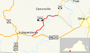
Virginia State Route 274 (SR 274) is a primary state highway in the U.S. state of Virginia. Known as Riverside Drive, the state highway runs 7.36 miles (11.84 km) from U.S. Route 58 and US 221 near Independence east to SR 94 near Fries. Together with SR 94, SR 274 forms part of the old alignment of US 58 and US 221 between Independence and Galax in eastern Grayson County.
Route description
SR 274 begins at US 58 and US 221 (Grayson Parkway) a short distance east of the town of Independence. The state highway heads northeast and veers north on reaching the New River. SR 274 follows the river north and east along its left bank, once veering away from the river as it bends southeast. The state highway reaches its eastern terminus at SR 94, which heads north as Scenic Road toward Fries and east as a continuation of Riverside Drive.[1][2]
Major intersections
The entire route is in Grayson County.
| Location | mi[1] | km | Destinations | Notes | |
|---|---|---|---|---|---|
| 0.00 | 0.00 | ||||
| 7.36 | 11.84 | ||||
| 1.000 mi = 1.609 km; 1.000 km = 0.621 mi | |||||
References
- ↑ 1.0 1.1 1.2 "2010 Traffic Data". Virginia Department of Transportation. 2010. Retrieved 2012-01-04.
- Grayson County (PDF)
- ↑ Google (2012-01-04). "Virginia State Route 274" (Map). Google Maps. Google. Retrieved 2012-01-04.
External links
Route map: Bing
