Vinschgau
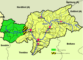
Map of South Tyrol with the Vinschgau district highlighted in green. The yellow-black stripes mark the geographical extent of the valley.
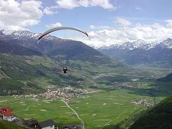
Upper Vinschgau Valley.
The Vinschgau (Italian: Val Venosta, German: Vinschgau, Ladin: Vnuost, medieval: Finsgowe) or Vinschgau Valley[1] is the upper part of the Etsch or Adige river valley, in the western part of the province of South Tyrol, Italy.
Overview
The valley runs in a west-east orientation, between the Reschen Pass and Meran. Due to a rather warm climate and a lack of rain (400mm per year), the apple orchards there are irrigated. According to the 2001 census, 96.51% of the population of the valley speak German, 3.41% Italian and 0.08% Ladin as first language.[2]
Subdivision
Vinschgau is also the name of a district (German: Bezirksgemeinschaft, Italian: comprensorio), in which the 13 municipalities of the valley cooperate. These municipalities are:
- Glurns
- Graun im Vinschgau
- Kastelbell-Tschars
- Laas
- Latsch
- Mals
- Martell
- Prad am Stilfser Joch
- Schlanders (district capital)
- Schluderns
- Schnals
- Stilfs
- Taufers im Münstertal
References
- ↑ Allgemeiner historischer Handatlas, Gustav Droysen
- ↑ Bevölkerung und soziales Leben, Statistisches Jahrbuch 2006, p. 120, tab. 3.19
External links
 Media related to Vinschgau at Wikimedia Commons
- Vinschgau District (German) (Italian)
| ||||||||||