Villefranche-d'Allier
| Villefranche-d’Allier | ||
|---|---|---|
|
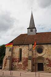
The church in Villefranche-d'Allier | ||
| ||
 Villefranche-d’Allier | ||
|
Location within Auvergne region  Villefranche-d’Allier | ||
| Coordinates: 46°23′51″N 2°51′29″E / 46.3975°N 2.8581°ECoordinates: 46°23′51″N 2°51′29″E / 46.3975°N 2.8581°E | ||
| Country | France | |
| Region | Auvergne | |
| Department | Allier | |
| Arrondissement | Montluçon | |
| Canton | Montmarault | |
| Intercommunality | Région de Montmarault | |
| Government | ||
| • Mayor (2008–2014) | Bruno Rojouan | |
| Area1 | 39.63 km2 (15.30 sq mi) | |
| Population (2008)2 | 1,325 | |
| • Density | 33/km2 (87/sq mi) | |
| INSEE/Postal code | 03315 / 03430 | |
| Elevation |
227–351 m (745–1,152 ft) (avg. 280 m or 920 ft) | |
|
1 French Land Register data, which excludes lakes, ponds, glaciers > 1 km² (0.386 sq mi or 247 acres) and river estuaries. 2 Population without double counting: residents of multiple communes (e.g., students and military personnel) only counted once. | ||

Villefranche-d'Allier is a commune in the Allier department in Auvergne in central France.
Population
| Historical population | ||
|---|---|---|
| Year | Pop. | ±% |
| 1962 | 1,279 | — |
| 1968 | 1,347 | +5.3% |
| 1975 | 1,273 | −5.5% |
| 1982 | 1,272 | −0.1% |
| 1990 | 1,360 | +6.9% |
| 1999 | 1,306 | −4.0% |
| 2008 | 1,325 | +1.5% |
See also
References
| Wikimedia Commons has media related to Villefranche-d'Allier. |