Villafranca in Lunigiana
| Villafranca in Lunigiana | ||
|---|---|---|
| Comune | ||
| Comune di Villafranca in Lunigiana | ||
 | ||
| ||
 Villafranca in Lunigiana Location of Villafranca in Lunigiana in Italy | ||
| Coordinates: 44°17′N 9°57′E / 44.283°N 9.950°ECoordinates: 44°17′N 9°57′E / 44.283°N 9.950°E | ||
| Country | Italy | |
| Region | Tuscany | |
| Province | Massa and Carrara (MS) | |
| Frazioni | Filetto, Fornoli, Irola, Malgrate Lunigiana, Merizzo, Mocrone, Virgoletta | |
| Government | ||
| • Mayor | Lucio Barani | |
| Area | ||
| • Total | 29.5 km2 (11.4 sq mi) | |
| Elevation | 138 m (453 ft) | |
| Population (1 January 2008)[1] | ||
| • Total | 4,819 | |
| • Density | 160/km2 (420/sq mi) | |
| Demonym | Villafranchesi | |
| Time zone | CET (UTC+1) | |
| • Summer (DST) | CEST (UTC+2) | |
| Postal code | 54028 | |
| Dialing code | 0187 | |
| Patron saint | St. John the Baptist | |
| Saint day | 24 June | |
| Website | Official website | |

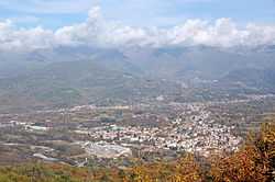
Villafranca in Lunigiana is a comune (municipality) in the Province of Massa and Carrara in the Italian region Tuscany, located about 120 kilometres (75 miles) northwest of Florence and about 35 km (22 mi) northwest of Massa.
It is located on the Via Francigena, and has maintained part of the medieval historical center. In the frazione of Mocrone is the small church of San Maurizio, from the 13th-14th centuries.
References
| Wikimedia Commons has media related to Villafranca in Lunigiana. |