Vila Nova de Foz Côa
| Vila Nova de Foz Côa | |||
|---|---|---|---|
| Municipality | |||
| |||
 | |||
| Coordinates: 40°05′N 7°08′W / 40.083°N 7.133°WCoordinates: 40°05′N 7°08′W / 40.083°N 7.133°W | |||
| Country |
| ||
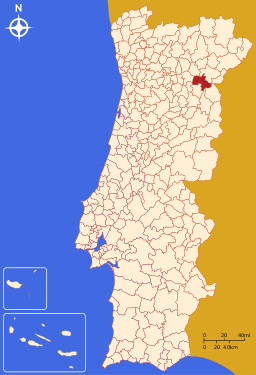
| Region | Norte | ||
| Subregion | Douro | ||
| Intermunic. comm. | Douro | ||
| District | Guarda | ||
| Parishes | 14 | ||
| Government | |||
| • President | Emílio António Pessoa Mesquita (PS) | ||
| Area | |||
| • Total | 398.2 km2 (153.7 sq mi) | ||
| Population (2011) | |||
| • Total | 7,312 | ||
| • Density | 18/km2 (48/sq mi) | ||
| Time zone | WET/WEST (UTC+0/+1) | ||
| Website | http://www.cm-fozcoa.pt | ||
Vila Nova de Foz Côa (Portuguese pronunciation: [ˈvilɐ ˈnɔvɐ ðɨ ˈfɔʃ ˈkoɐ]) is a city and a municipality in the district of Guarda, Portugal. The population in 2011 was 7,312,[1] in an area of 398.15 square kilometres (153.73 sq mi).[2] The city population is around 3,300. Main rivers in the municipal territory include the Douro and the Côa.
The municipality includes parts in the Côa Valley Archaeological site, declared by UNESCO as a World Heritage Site, which partially shares with Figueira de Castelo Rodrigo and Pinhel also located in the Guarda district.
The closest railway station is Pocinho, now the eastern terminus of the Douro railway line. This line (in Portuguese: Linha do Douro) has passenger trains services from Pocinho to Tua, Peso da Régua, Livração, Marco de Canaveses, Penafiel, Paredes, Ermesinde (for connections to Braga, Guimarães, Viana do Castelo, Rio Tinto and Porto).
Parishes
Administratively, the municipality is divided into 14 civil parishes (freguesias):[3]
- Almendra
- Castelo Melhor
- Cedovim
- Chãs
- Custóias
- Freixo de Numão
- Horta
- Muxagata
- Numão
- Santa Comba
- Sebadelhe
- Seixas
- Touça
- Vila Nova de Foz Côa
References
- ↑ Instituto Nacional de Estatística
- ↑ Direção-Geral do Território
- ↑ Diário da República. "Law nr. 11-A/2013, pages 552 133-134" (pdf) (in Portuguese). Retrieved 4 August 2014.
External links
| ||||||